
| CHERRY CAPITAL TRAVERSE CITY MI |
| |
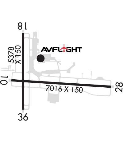
| Lat: N 4444.5 Long: W 08534.9 Elev: 624 Var: +05 Longest Runway: 7016 | ||
| Dept. ATIS: 119.17 Arr. ATIS: 119.17 Ground: 121.8 Tower: 124.2 | ||
| ||||||||||||||||||||||||||||||
| ||||||||||||||||||||||||||||||
| ||||||||||||||||||||||||||||||
| ||||||||||||||||||||||||||||||
| Rwy | Rwy | |||||||
| 7016x150 | 7016' | 7016x150 | 7016' | 110.70 - 278° | ||||
| 5378x150 | 5106' | 5378x150 | 5378' | |||||
| Runway ID | Single Wheel | Double Wheel | Double Tandem Wheel | Dual Double Wheel |
| 10/28 | 120,000 | 230,000 | 440,000 | N/A |
| 18/36 | 70,000 | 110,000 | 190,000 | N/A |
| These numbers are Advisory and are not limits. The Airport Manager should have more accurate Weight Limits | ||||
 Airport Diagram might not be current. | |
| Facility Name: | CHERRY CAPITAL |
| City Name: | TRAVERSE CITY |
| County: | GRAND TRAVERSE |
| State abbrev: | MI |
| State Name: | MICHIGAN |
| Ownership: | PUBLICLY OWNED |
| Use: | OPEN TO THE PUBLIC |
| Owner's Name: | GRAND TRAVERSE & LEELANAU CO |
| Address: | NORTHWESTERN RGNL ARPT CMSN, 727 FLY DONT DR |
| TRAVERSE CITY, MI 49686 | |
| Owner's Phone: | 231-947-2250 |
| Manager's Name: | KEVIN C KLEIN, AAE |
| Address: | 727 FLY DONT DR |
| TRAVERSE CITY, MI 49686 | |
| Phone: | 231-947-2250 |
| FAA Region: | GREAT LAKES |
| FAA Field Office: | DET |
| Date | Sunrise | Sunset |
|---|---|---|
| 09/24/21 Friday | 7:31 | 19:36 |
| 09/25/21 Saturday | 7:33 | 19:35 |
| 09/26/21 Sunday | 7:34 | 19:33 |
| 09/27/21 Monday | 7:35 | 19:31 |
| 09/28/21 Tuesday | 7:36 | 19:29 |
| 09/29/21 Wednesday | 7:38 | 19:27 |
| 09/30/21 Thursday | 7:39 | 19:25 |
| 10/01/21 Friday | 7:40 | 19:23 |
| 10/02/21 Saturday | 7:41 | 19:21 |
| 10/03/21 Sunday | 7:42 | 19:20 |
| 10/04/21 Monday | 7:44 | 19:18 |
| 10/05/21 Tuesday | 7:45 | 19:16 |
| 10/06/21 Wednesday | 7:46 | 19:14 |
| 10/07/21 Thursday | 7:47 | 19:12 |
| Airport Attendance Schedule | 7 Days A Week 0400-0100; DURG HRS WHEN ARPT IS UNATNDD CALL ARPT OPNS 231-313-0928. FOR FBO HRS OF OPS CALL 231-929-1126. |
| Airport Status | OPERATIONAL (This Status can change at any time - please check NOTAMS) |
| Airport Lighting Schedule | WHEN ATCT CLSD ACTVT MALSR RWY 10 & 28; REIL RWY 36; HIRL RWY 10/28; MIRL RWY 18/36 - CTAF. PAPI RWY 10 & 28; VASI RWY 18 & 36 OPR CONSLY. |
| Airport Storage Available | Tie Downs, Hanger |
| Extra Services Available | Air Freight, Crop Dusting, Air Ambulance, Avionics, Cargo Handling, Charter, Flight Instruction, Aircraft Rental |
| Wind Indicator | YES - (lighted) |
| Control Tower | YES |
| CTAF Frequency | 124.200 |
| Unicom Frequency | 122.950 |
| Rotating Beacon Color | CLEAR-GREEN (Light Land Airport) |
| Segmented Circle | YES |
| Landing Fee | YES |
| Airport Inspected | FEDERAL - performed by FAA AIRPORTS FIELD PERSONNEL |
| Inspection Date | 08/15/2019 |
| Type of Fuel Available | Grade 100LL, JET A; -10100LL SELF SVC FUEL AVBL WITH CREDIT CARD DURG FBO HRS ONLY. |
| Airframe Repair Service | MAJOR |
| Power Plant Repair Service | MAJOR |
| Latitude | N4444.5 |
| Longitude | W08534.9 (ESTIMATED) |
| Arpt Elevation | 623ft (SURVEYED) |
| Magnetic Variation | 05W |
| 2 miles S | of TRAVERSE CITY |
| Traffic Pattern Altitude | |
| Sectional Chart | GREEN BAY |
| Operations (Reported) | Yearly | Avg. Daily |
|---|---|---|
| General Aviation Transient | 32288 | 88 |
| General Aviation Local | 39434 | 108 |
| Air Taxi | 8637 | 24 |
| Commerical | 11187 | 31 |
| Commuter | 0 | 0 |
| Military | 6378 | 17 |
| Aircraft based on Field | |
|---|---|
| General Aviation Singles | 82 |
| General Aviation Multi | 13 |
| Jet Aircraft | 3 |
| General Aviation Helicopters | 6 |
| Military Aircraft | 0 |
| Gliders | 0 |
| Ultralights | 0 |
| FSS on field | NO |
| FSS tie-in | LANSING |
| FSS Phone | 1-800-WX-BRIEF |
| Who issues Notams | TVC |
| Notam D service at airport | YES |
| ARTCC Name | MINNEAPOLIS |
| Airport Certification | AIRPORT RECEIVING SCHEDULED AIR CARRIER SERVICE FROM CARRIERS CERTIFICATED BY THE CIVIL AERONAUTICS BOARD; 48 HR PPR FOR UNSKED ACR OPS WITH OVER 30 PSGR SEATS - CALL AMGR. |
| Aircraft Rescue & Firefighting Index | AIRPORT HAS A CERTIFICATE UNDER CFR PART 139 |
| Airport of Entry | No |
| Custom Landing Rights | No |
| Joint Civil/Military | No |
| Military Landing rights | YES |
| NATIONAL PLAN OF INTEGRATED AIRPORT SYSTEMS (NPIAS) |
| GRANT AGREEMENTS UNDER FAAP/ADAP/AIP |
| SURPLUS PROPERTY AGREEMENT UNDER PUBLIC LAW 289 |
| ADVANCE PLANNING AGREEMENT UNDER FAAP |
| ASSURANCES PURSUANT TO TITLE VI, CIVIL RIGHTS ACT OF 1964 |
| AGREEMENT UNDER DLAND OR DCLA HAS EXPIRED. |
| ALL ACFT CHRGD OVNGT RAMP PRKG FEE EXC MIL. ALL ACFT CHRGD LNDG FEE EXC PVT OWNED, SINGLE ENGINE ACFT. |
| NO GENERAL AVN ACFT ON THE AIR CARRIER RAMP. |
| FOR CD IF UNA TO CTC ON FSS FREQ, CTC MINNEAPOLIS ARTCC AT 651-463-5588. |
| BIRDS ON AND INVOF ARPT. |
| SNOW REMOVAL OPNS IN PROGRESS WINTER MONTHS; SNOW COMMAND WILL BE MONITORING CTAF DURING NON-ATCT HOURS. ACFT LNDG/DEPARTING TVC SHOULD ANNOUNCE THEIR INTENTIONS ON CTAF WHEN ATCT CLSD. |
| TWY C-2/C-3 EAST OF TWY C NOT AVBL TO ACR ACFT. |
| FLIGHT CREWS SHOULD READ BACK ALL ADZY INFO PRVDD BY SNOW COMMAND. |
| ARPT SFC COND UNMON BTN 0100 - 0400. |
| USCG - PPR CTC TRAVERSE CITY FM 21 PRIMARY, 345.0 SECONDARY 15 MINS PRIOR TO ENTERING CG RAMP. |
| PARASAILING OPNS 1.5 NM NORTHEAST OF ARPT FROM MEMORIAL DAY TO LABOR DAY 600 FT AGL FROM SR-SS DAILY. |
Airport Communications & Frequencies:
| |||||||||||||||||||
| Runway: 10 | Runway: 28 | ||
| Mag heading: | 99° | Mag heading: | 279° |
| Rwy Slope: | -.24% Down | Rwy Slope: | .24% Up |
| Approach: | Approach: | ILS | |
| Pattern: | Left Traffic | Pattern: | Left Traffic |
| Markings: | PRECISION INSTRUMENT | Markings: | PRECISION INSTRUMENT |
| Marking Condition: | GOOD | Marking Condition: | GOOD |
| Arresting Dev: | Arresting Dev: | ||
| Lat & Long: | N4444.5 W08535.5 | Lat. & Long.: | N4444.4 W08533.8 |
| Elev: | 623.7 ft. MSL | Elev: | 606.9 ft. MSL |
| TCH: | 55 ft. AGL | TCH: | 45 ft. AGL |
| Visual Glide Path: | 3.00 degrees | Visual Glide Path: | 3.00 degrees |
| Displaced Threshold: | No | Displaced Threshold: | No |
| Touchdown Zone: | YES | Touchdown Zone: | YES |
| Touchdown Elev.: | 623.7 feet | Touchdown Elev.: | 616.1 feet |
| Visual Glide Slope: | 4-Light PAPI on LEFT side of Runway | Visual Glide Slope: | 4-Light PAPI on LEFT side of Runway |
| RVR Equipment: | RVR Equipment: | ||
| RVV Equipment: | NO | RVV Equipment: | NO |
| Approach Lights: | MALSR - 1,400 foot medium intensity approach lighting system with runway alignment indicator lights | Approach Lights: | MALSR - 1,400 foot medium intensity approach lighting system with runway alignment indicator lights |
| REIL: | NO | REIL: | NO |
| Centerline Lights: | NO | Centerline Lights: | NO |
| Touchdown lights: | NO | Touchdown lights: | NO |
| Runway Category: | Runway with a Non-precision Approach having visibility minimums greater than 3/4 mile | Runway Category: | Precision Instrument Runway |
| Declared Distances: | TORA:7016' TODA:7016' ASDA:7016' LDA:7016' | Declared Distances: | TORA:7016' TODA:7016' ASDA:7016' LDA:7016' |
| Obstructions: | TREE | Obstructions: | TOWER |
| Marked: | NOT Marked/Lighted | Marked: | LIGHTED |
| Clearance slope: | 37:1 | Clearance slope: | 36:1 |
| Obstruction height: | 80 feet AGL | Obstruction height: | 452 feet AGL |
| Dist. from runway: | 3209 feet | Dist. from runway: | 16493 feet |
| Centerline offset: | 187 right of centerline | Centerline offset: | 2359 feet left of centerline |
| Comments: | Comments: |
| Runway: 18 | Runway: 36 | ||
| Mag heading: | 185° | Mag heading: | 5° |
| Rwy Slope: | .12% Up | Rwy Slope: | -.12% Down |
| Approach: | Approach: | ||
| Pattern: | Left Traffic | Pattern: | Left Traffic |
| Markings: | NONPRECISION INSTRUMENT | Markings: | NONPRECISION INSTRUMENT |
| Marking Condition: | GOOD | Marking Condition: | GOOD |
| Arresting Dev: | Arresting Dev: | ||
| Lat & Long: | N4445.0 W08535.3 | Lat. & Long.: | N4444.1 W08535.3 |
| Elev: | 616.8 ft. MSL | Elev: | 623.4 ft. MSL |
| TCH: | 47 ft. AGL | TCH: | 53 ft. AGL |
| Visual Glide Path: | 3.00 degrees | Visual Glide Path: | 3.50 degrees |
| Displaced Threshold: | 272 feet | Displaced Threshold: | No |
| Touchdown Zone: | YES | Touchdown Zone: | YES |
| Touchdown Elev.: | 622.4 feet | Touchdown Elev.: | 623.6 feet |
| Visual Glide Slope: | 4-BOX VASI ON LEFT SIDE OF RUNWAY | Visual Glide Slope: | 4-BOX VASI ON LEFT SIDE OF RUNWAY |
| RVR Equipment: | RVR Equipment: | ||
| RVV Equipment: | NO | RVV Equipment: | NO |
| Approach Lights: | Approach Lights: | ||
| REIL: | NO | REIL: | YES |
| Centerline Lights: | NO | Centerline Lights: | NO |
| Touchdown lights: | NO | Touchdown lights: | NO |
| Runway Category: | Runway with a Non-precision Approach having visibility minimums greater than 3/4 mile | Runway Category: | Runway with a Non-precision Approach having visibility minimums greater than 3/4 mile |
| Declared Distances: | TORA:5378' TODA:5378' ASDA:5108' LDA:4838' | Declared Distances: | TORA:5378' TODA:5378' ASDA:5108' LDA:5108' |
| Obstructions: | TREE | Obstructions: | FENCE |
| Marked: | NOT Marked/Lighted | Marked: | NOT Marked/Lighted |
| Clearance slope: | 14:1; DTHR APCH SLOPE 19:1. | Clearance slope: | 40:1 |
| Obstruction height: | 70 feet AGL | Obstruction height: | 14 feet AGL |
| Dist. from runway: | 1199 feet | Dist. from runway: | 769 feet |
| Centerline offset: | 148 left of centerline | Centerline offset: | |
| Comments: | Comments: |
Thanks for using FltPlan.com
all rights reserved © 1999-2021 by Flight Plan LLC


