
| BOLTON FIELD COLUMBUS OH |
| |
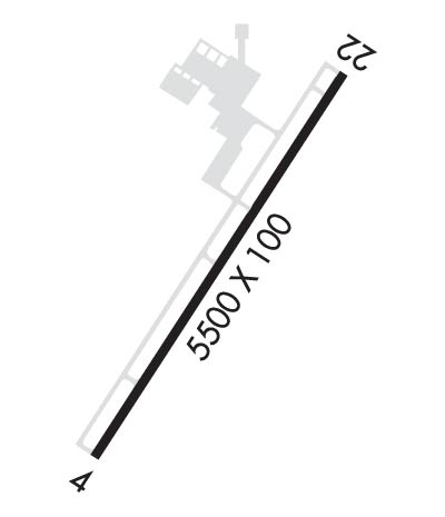
| Lat: N 3954.1 Long: W 08308.2 Elev: 904 Var: +05 Longest Runway: 5500 | ||
| AWOS: 135.92 Ground: 121.8 Tower: 128.1 | ||
| ||||||||||||||||||||||||||||||||||||||||||||
| ||||||||||||||||||||||||||||||||||||||||||||
| ||||||||||||||||||||||||||||||||||||||||||||
| Rwy | Rwy | |||||||
| 5500x100 | 5500' | 111.70 - 037° | 5500x100 | 5500' | ||||
| Runway ID | Single Wheel | Double Wheel | Double Tandem Wheel | Dual Double Wheel |
| 04/22 | 93,000 | 156,000 | 258,000 | N/A |
| These numbers are Advisory and are not limits. The Airport Manager should have more accurate Weight Limits | ||||
 Airport Diagram might not be current. | |
| Facility Name: | BOLTON FLD |
| City Name: | COLUMBUS |
| County: | FRANKLIN |
| State abbrev: | OH |
| State Name: | OHIO |
| Ownership: | PUBLICLY OWNED |
| Use: | OPEN TO THE PUBLIC |
| Owner's Name: | COLUMBUS REGIONAL ARPT AUTH |
| Address: | 4600 INTERNATIONAL GTWY |
| COLUMBUS, OH 43219-1779 | |
| Owner's Phone: | 614-239-4000 |
| Manager's Name: | CHARLIE GOODWIN |
| Address: | 2000 NORTON RD |
| COLUMBUS, OH 43228-3667 | |
| Phone: | 614-851-9900; H24 EMERG OPS 614-239-4029. |
| FAA Region: | GREAT LAKES |
| FAA Field Office: | DET |
| Date | Sunrise | Sunset |
|---|---|---|
| 03/15/25 Saturday | 7:45 | 19:39 |
| 03/16/25 Sunday | 7:43 | 19:40 |
| 03/17/25 Monday | 7:41 | 19:41 |
| 03/18/25 Tuesday | 7:40 | 19:42 |
| 03/19/25 Wednesday | 7:38 | 19:43 |
| 03/20/25 Thursday | 7:36 | 19:44 |
| 03/21/25 Friday | 7:35 | 19:45 |
| 03/22/25 Saturday | 7:33 | 19:46 |
| 03/23/25 Sunday | 7:32 | 19:47 |
| 03/24/25 Monday | 7:30 | 19:49 |
| 03/25/25 Tuesday | 7:28 | 19:50 |
| 03/26/25 Wednesday | 7:27 | 19:51 |
| 03/27/25 Thursday | 7:25 | 19:52 |
| 03/28/25 Friday | 7:23 | 19:53 |
| Airport Attendance Schedule | 7 Days A Week 0730-1930 |
| Airport Status | OPERATIONAL (This Status can change at any time - please check NOTAMS) |
| Airport Lighting Schedule | WHEN ATCT CLSD ACTVT MALSR RWY 04; REIL RWY 22; MIRL RWY 04/22 - CTAF. |
| Airport Storage Available | Tie Downs, Hanger |
| Extra Services Available | Charter, Flight Instruction, Aircraft Rental, Annual Surveying |
| Wind Indicator | YES - (lighted) |
| Control Tower | YES |
| CTAF Frequency | 128.100 |
| Unicom Frequency | |
| Rotating Beacon Color | WG |
| Segmented Circle | NO |
| Landing Fee | NO |
| Airport Inspected | STATE - performed by STATE AERONAUTICAL PERSONNEL |
| Inspection Date | 06/07/2022 |
| Type of Fuel Available | Grade 100LL, JET A-1 (icing inhibitor, freeze point -50C); -10100LL AVBL H24 SELF SVC VIA CREDIT CARD. |
| Airframe Repair Service | MAJOR |
| Power Plant Repair Service | MAJOR |
| Latitude | N3954.1 |
| Longitude | W08308.2 (ESTIMATED) |
| Arpt Elevation | 904ft (SURVEYED) |
| Magnetic Variation | 05W |
| 8 miles SW | of COLUMBUS |
| Traffic Pattern Altitude | 800 |
| Sectional Chart | CINCINNATI |
| Operations (Reported) | Yearly | Avg. Daily |
|---|---|---|
| General Aviation Transient | 0 | 0 |
| General Aviation Local | 0 | 0 |
| Air Taxi | 0 | 0 |
| Commerical | 0 | 0 |
| Commuter | 0 | 0 |
| Military | 0 | 0 |
| Aircraft based on Field | |
|---|---|
| General Aviation Singles | 0 |
| General Aviation Multi | 0 |
| Jet Aircraft | 0 |
| General Aviation Helicopters | 0 |
| Military Aircraft | 0 |
| Gliders | 0 |
| Ultralights | 0 |
| FSS on field | NO |
| FSS tie-in | DAYTON |
| FSS Phone | 1-800-WX-BRIEF |
| Who issues Notams | TZR |
| Notam D service at airport | YES |
| ARTCC Name | INDIANAPOLIS |
| Airport Certification | |
| Aircraft Rescue & Firefighting Index | None |
| Airport of Entry | No |
| Custom Landing Rights | No |
| Joint Civil/Military | No |
| Military Landing rights | YES |
| NATIONAL PLAN OF INTEGRATED AIRPORT SYSTEMS (NPIAS) |
| GRANT AGREEMENTS UNDER FAAP/ADAP/AIP |
| ASSURANCES PURSUANT TO TITLE VI, CIVIL RIGHTS ACT OF 1964 |
| HIGH TENSION PLINES/TOWERS NE-SE. |
| BLN & BANNER ACT ON & INVOF ARPT. |
| BIRDS & OTR WILDLIFE ON & INVOF ARPT. |
| FOR FUEL & ACFT SVCS CTC FBO ON 123.3. |
| FOR CD WHEN ATCT IS CLSD CTC COLUMBUS APCH AT 614-338-8537. |
| RWY 04 CALM WIND RWY. |
| RWY 04/2 2 PCR VALUE: 364/F/B/X/T |
Airport Communications & Frequencies:
| |||||||||||||||||||||||||
| Runway: 04 | Runway: 22 | ||
| Mag heading: | 37° | Mag heading: | 217° |
| Rwy Slope: | .04% Up | Rwy Slope: | -.04% Down |
| Approach: | ILS | Approach: | |
| Pattern: | Left Traffic | Pattern: | Left Traffic |
| Markings: | PRECISION INSTRUMENT | Markings: | PRECISION INSTRUMENT |
| Marking Condition: | GOOD | Marking Condition: | GOOD |
| Arresting Dev: | Arresting Dev: | ||
| Lat & Long: | N3953.7 W08308.5 | Lat. & Long.: | N3954.5 W08307.9 |
| Elev: | 901.6 ft. MSL | Elev: | 903.6 ft. MSL |
| TCH: | 25 ft. AGL | TCH: | 25 ft. AGL |
| Visual Glide Path: | 3.00 degrees | Visual Glide Path: | 3.00 degrees |
| Displaced Threshold: | No | Displaced Threshold: | No |
| Touchdown Zone: | YES | Touchdown Zone: | YES |
| Touchdown Elev.: | 904.1 feet | Touchdown Elev.: | 904.2 feet |
| Visual Glide Slope: | 4-Light PAPI on LEFT side of Runway | Visual Glide Slope: | 4-Light PAPI on LEFT side of Runway |
| RVR Equipment: | RVR Equipment: | ||
| RVV Equipment: | NO | RVV Equipment: | NO |
| Approach Lights: | MALSR - 1,400 foot medium intensity approach lighting system with runway alignment indicator lights | Approach Lights: | |
| REIL: | NO | REIL: | YES |
| Centerline Lights: | NO | Centerline Lights: | NO |
| Touchdown lights: | NO | Touchdown lights: | NO |
| Runway Category: | Precision Instrument Runway | Runway Category: | Runway with a Non-precision Approach |
| Declared Distances: | Declared Distances: |
Thanks for using FltPlan.com
all rights reserved © 1999-2025 by Flight Plan LLC
