
| ROCK HILL/YORK CO/BRYANT FIELD ROCK HILL SC |
| |
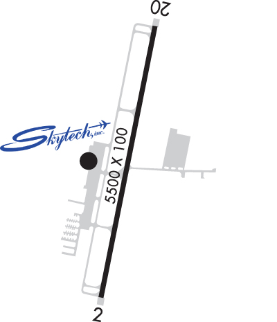
| Lat: N 3459.3 Long: W 08103.4 Elev: 666 Var: +05 Longest Runway: 5500 | ||
| Clr Del: 126.85 AWOS: 120.77 CTAF: 123.05 | ||
| ||||||||||||||||||||||||||||||||||||||||||||||||||||||||||||||||||||
| ||||||||||||||||||||||||||||||||||||||||||||||||||||||||||||||||||||
| ||||||||||||||||||||||||||||||||||||||||||||||||||||||||||||||||||||
| FBOs at nearby airports who want your business: | |||||||||||||||||
| |||||||||||||||||
| Rwy | Rwy | |||||||
| 5500x100 | 5500' | 108.50 - 016° | 5500x100 | 5500' | ||||
| Runway ID | Single Wheel | Double Wheel | Double Tandem Wheel | Dual Double Wheel |
| 02/20 | 78,000 | 104,000 | N/A | N/A |
| These numbers are Advisory and are not limits. The Airport Manager should have more accurate Weight Limits | ||||
 Airport Diagram might not be current. | |
| Facility Name: | ROCK HILL/YORK COUNTY/BRYANT FLD |
| City Name: | ROCK HILL |
| County: | YORK |
| State abbrev: | SC |
| State Name: | SOUTH CAROLINA |
| Ownership: | PUBLICLY OWNED |
| Use: | OPEN TO THE PUBLIC |
| Owner's Name: | CITY OF ROCK HILL |
| Address: | BOX 11706 |
| ROCK HILL, SC 29731 | |
| Owner's Phone: | 803-329-7010 |
| Manager's Name: | STEVEN A. GOULD JR., C.M.; FBO MGR: ANTHONY CHERRY, 803-366-5108. |
| Address: | 550 AIRPORT RD, SUITE 205 |
| ROCK HILL, SC 29732 | |
| Phone: | 803-329-5560 |
| FAA Region: | SOUTHERN |
| FAA Field Office: | ATL |
| Date | Sunrise | Sunset |
|---|---|---|
| 09/24/21 Friday | 7:13 | 19:18 |
| 09/25/21 Saturday | 7:14 | 19:17 |
| 09/26/21 Sunday | 7:15 | 19:16 |
| 09/27/21 Monday | 7:16 | 19:14 |
| 09/28/21 Tuesday | 7:16 | 19:13 |
| 09/29/21 Wednesday | 7:17 | 19:11 |
| 09/30/21 Thursday | 7:18 | 19:10 |
| 10/01/21 Friday | 7:19 | 19:09 |
| 10/02/21 Saturday | 7:20 | 19:07 |
| 10/03/21 Sunday | 7:20 | 19:06 |
| 10/04/21 Monday | 7:21 | 19:04 |
| 10/05/21 Tuesday | 7:22 | 19:03 |
| 10/06/21 Wednesday | 7:23 | 19:02 |
| 10/07/21 Thursday | 7:23 | 19:00 |
| Airport Attendance Schedule | 7 Days A Week 0800-2000 |
| Airport Status | OPERATIONAL (This Status can change at any time - please check NOTAMS) |
| Airport Lighting Schedule | DUSK-2300. MIRL RY 02/20 & MALSR RY 02 PRESET MED INTST DUSK-2300; TO INCR INTST & ACTVT AFTER 2300 - CTAF. |
| Airport Storage Available | Tie Downs, Hanger |
| Extra Services Available | Air Freight, Flight Instruction, Aircraft Rental, Annual Surveying |
| Wind Indicator | YES - (lighted) |
| Control Tower | NO |
| CTAF Frequency | 123.050 |
| Unicom Frequency | 123.050 |
| Rotating Beacon Color | CLEAR-GREEN (Light Land Airport) |
| Segmented Circle | YES |
| Landing Fee | NO |
| Airport Inspected | STATE - performed by STATE AERONAUTICAL PERSONNEL |
| Inspection Date | 09/18/2019 |
| Type of Fuel Available | Grade 100LL, JET A (freeze point -40C) |
| Airframe Repair Service | MAJOR |
| Power Plant Repair Service | MAJOR |
| Latitude | N3459.3 |
| Longitude | W08103.4 (ESTIMATED) |
| Arpt Elevation | 666ft (SURVEYED) |
| Magnetic Variation | 05W |
| 4 miles NW | of ROCK HILL |
| Traffic Pattern Altitude | |
| Sectional Chart | CHARLOTTE |
| Operations (Reported) | Yearly | Avg. Daily |
|---|---|---|
| General Aviation Transient | 12067 | 33 |
| General Aviation Local | 14644 | 40 |
| Air Taxi | 1289 | 4 |
| Commerical | 0 | 0 |
| Commuter | 0 | 0 |
| Military | 100 | 0 |
| Aircraft based on Field | |
|---|---|
| General Aviation Singles | 125 |
| General Aviation Multi | 12 |
| Jet Aircraft | 2 |
| General Aviation Helicopters | 3 |
| Military Aircraft | 0 |
| Gliders | 0 |
| Ultralights | 0 |
| FSS on field | NO |
| FSS tie-in | ANDERSON |
| FSS Phone | 1-800-WX-BRIEF |
| Who issues Notams | UZA |
| Notam D service at airport | YES |
| ARTCC Name | ATLANTA |
| Airport Certification | |
| Aircraft Rescue & Firefighting Index | None |
| Airport of Entry | No |
| Custom Landing Rights | No |
| Joint Civil/Military | No |
| Military Landing rights | YES |
| NATIONAL PLAN OF INTEGRATED AIRPORT SYSTEMS (NPIAS) |
| GRANT AGREEMENTS UNDER FAAP/ADAP/AIP |
| ASSURANCES PURSUANT TO TITLE VI, CIVIL RIGHTS ACT OF 1964 |
| WILDLIFE INVOF ARPT. |
| VOLUNTARY NOISE ABATEMENT PROC IN EFCT. |
| FOR CD IF UNA TO CTC ON FSS FREQ, CTC CHARLOTTE APCH AT 704-359-0241. |
Airport Communications & Frequencies:
| ||||||||||||||||
| Runway: 02 | Runway: 20 | ||
| Mag heading: | 16° | Mag heading: | 196° |
| Rwy Slope: | -.10% Down | Rwy Slope: | .10% Up |
| Approach: | ILS/DME | Approach: | |
| Pattern: | Left Traffic | Pattern: | Left Traffic |
| Markings: | PRECISION INSTRUMENT | Markings: | PRECISION INSTRUMENT |
| Marking Condition: | GOOD | Marking Condition: | GOOD |
| Arresting Dev: | Arresting Dev: | ||
| Lat & Long: | N3458.8 W08103.5 | Lat. & Long.: | N3459.7 W08103.3 |
| Elev: | 666.3 ft. MSL | Elev: | 661.0 ft. MSL |
| TCH: | 41 ft. AGL | TCH: | 40 ft. AGL |
| Visual Glide Path: | 3.00 degrees | Visual Glide Path: | 3.00 degrees |
| Displaced Threshold: | No | Displaced Threshold: | No |
| Touchdown Zone: | YES | Touchdown Zone: | YES |
| Touchdown Elev.: | 666.3 feet | Touchdown Elev.: | 662.4 feet |
| Visual Glide Slope: | 2-Light PAPI on LEFT side of Runway | Visual Glide Slope: | 2-Light PAPI on LEFT side of Runway |
| RVR Equipment: | RVR Equipment: | ||
| RVV Equipment: | NO | RVV Equipment: | NO |
| Approach Lights: | MALSR - 1,400 foot medium intensity approach lighting system with runway alignment indicator lights | Approach Lights: | |
| REIL: | NO | REIL: | NO |
| Centerline Lights: | NO | Centerline Lights: | NO |
| Touchdown lights: | NO | Touchdown lights: | NO |
| Runway Category: | Precision Instrument Runway | Runway Category: | Runway with a Non-precision Approach having visibility minimums greater than 3/4 mile |
| Declared Distances: | Declared Distances: | ||
| Obstructions: | TREE | Obstructions: | TREE |
| Marked: | NOT Marked/Lighted | Marked: | NOT Marked/Lighted |
| Clearance slope: | 32:1 | Clearance slope: | 20:1 |
| Obstruction height: | 86 feet AGL | Obstruction height: | 80 feet AGL |
| Dist. from runway: | 3026 feet | Dist. from runway: | 1831 feet |
| Centerline offset: | 23 left of centerline | Centerline offset: | 615 feet left of centerline |
| Comments: | Comments: |
Thanks for using FltPlan.com
all rights reserved © 1999-2021 by Flight Plan LLC