
| PORTER COUNTY MUNI VALPARAISO IN |
| |
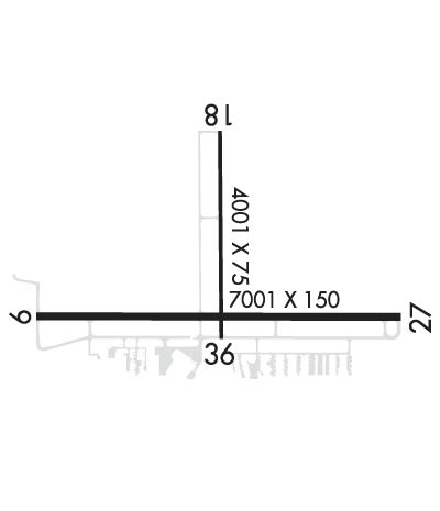
| Lat: N 4127.2 Long: W 08700.4 Elev: 770 Var: +02 Longest Runway: 7001 | ||
| Clr Del: 120.52 AWOS: 125.87 CTAF: 122.72 | ||
| ||||||||||||||||||||||||||||||||||||||||||||
| ||||||||||||||||||||||||||||||||||||||||||||
| ||||||||||||||||||||||||||||||||||||||||||||
| Rwy | Rwy | |||||||
| 7001x150 | 6501' | 7001x150 | 7001' | 109.70 - 272° | ||||
| 4001x75 | 4001' | 4001x75 | 4001' | |||||
| Runway ID | Single Wheel | Double Wheel | Double Tandem Wheel | Dual Double Wheel |
| 09/27 | N/A | 250,000 | 375,000 | N/A |
| 18/36 | 30,000 | 45,000 | N/A | N/A |
| These numbers are Advisory and are not limits. The Airport Manager should have more accurate Weight Limits | ||||
 Airport Diagram might not be current. | |
| Facility Name: | PORTER COUNTY RGNL |
| City Name: | VALPARAISO |
| County: | PORTER |
| State abbrev: | IN |
| State Name: | INDIANA |
| Ownership: | PUBLICLY OWNED |
| Use: | OPEN TO THE PUBLIC |
| Owner's Name: | PORTER COUNTY MUNI ARPT AUTH |
| Address: | 4207 MURVIHILL RD |
| VALPARAISO, IN 46383 | |
| Owner's Phone: | 219-462-6508 |
| Manager's Name: | KYLE J. KUEBLER |
| Address: | 4207 MURVIHILL RD |
| VALPARAISO, IN 46383 | |
| Phone: | 219-462-6508 |
| FAA Region: | GREAT LAKES |
| FAA Field Office: | CHI |

| Date | Sunrise | Sunset |
|---|---|---|
| 09/24/21 Friday | 6:37 | 18:42 |
| 09/25/21 Saturday | 6:38 | 18:40 |
| 09/26/21 Sunday | 6:39 | 18:39 |
| 09/27/21 Monday | 6:40 | 18:37 |
| 09/28/21 Tuesday | 6:41 | 18:35 |
| 09/29/21 Wednesday | 6:42 | 18:34 |
| 09/30/21 Thursday | 6:43 | 18:32 |
| 10/01/21 Friday | 6:45 | 18:30 |
| 10/02/21 Saturday | 6:46 | 18:29 |
| 10/03/21 Sunday | 6:47 | 18:27 |
| 10/04/21 Monday | 6:48 | 18:25 |
| 10/05/21 Tuesday | 6:49 | 18:23 |
| 10/06/21 Wednesday | 6:50 | 18:22 |
| 10/07/21 Thursday | 6:51 | 18:20 |
| Airport Attendance Schedule | MON-FRI 0600-2200, SAT-SUN 0700-1900 |
| Airport Status | OPERATIONAL (This Status can change at any time - please check NOTAMS) |
| Airport Lighting Schedule | ACTVT MALSR RWY 27; REIL RWY 9, 18 & 36; PAPI RWY 9, 18, 27 & 36; HIRL RWY 09/27; MIRL RWY 18/36 - CTAF. HIRL RWY 09/27; MIRL RWY 18/36; PRESET TO LOW INTST DUSK - 2300, INCR INTST - CTAF. |
| Airport Storage Available | Tie Downs, Hanger |
| Extra Services Available | Charter, Flight Instruction, Aircraft Rental |
| Wind Indicator | YES - (lighted) |
| Control Tower | NO |
| CTAF Frequency | 122.725 |
| Unicom Frequency | 122.725 |
| Rotating Beacon Color | CLEAR-GREEN (Light Land Airport) |
| Segmented Circle | YES |
| Landing Fee | NO |
| Airport Inspected | FEDERAL - performed by FAA AIRPORTS FIELD PERSONNEL |
| Inspection Date | 01/23/2020 |
| Type of Fuel Available | Grade 100LL, JET A (freeze point -40C) |
| Airframe Repair Service | MAJOR |
| Power Plant Repair Service | MAJOR |
| Latitude | N4127.2 |
| Longitude | W08700.4 (ESTIMATED) |
| Arpt Elevation | 770ft (SURVEYED) |
| Magnetic Variation | 02W |
| 1 miles SE | of VALPARAISO |
| Traffic Pattern Altitude | |
| Sectional Chart | CHICAGO |
| Operations (Reported) | Yearly | Avg. Daily |
|---|---|---|
| General Aviation Transient | 29353 | 80 |
| General Aviation Local | 38438 | 105 |
| Air Taxi | 1398 | 4 |
| Commerical | 0 | 0 |
| Commuter | 0 | 0 |
| Military | 699 | 2 |
| Aircraft based on Field | |
|---|---|
| General Aviation Singles | 116 |
| General Aviation Multi | 6 |
| Jet Aircraft | 5 |
| General Aviation Helicopters | 1 |
| Military Aircraft | 0 |
| Gliders | 0 |
| Ultralights | 0 |
| FSS on field | NO |
| FSS tie-in | TERRE HAUTE |
| FSS Phone | 1-800-WX-BRIEF |
| Who issues Notams | VPZ |
| Notam D service at airport | YES |
| ARTCC Name | CHICAGO |
| Airport Certification | |
| Aircraft Rescue & Firefighting Index | AIRPORT HAS A CERTIFICATE UNDER CFR PART 139 |
| Airport of Entry | No |
| Custom Landing Rights | No |
| Joint Civil/Military | No |
| Military Landing rights | YES |
| NATIONAL PLAN OF INTEGRATED AIRPORT SYSTEMS (NPIAS) |
| GRANT AGREEMENTS UNDER FAAP/ADAP/AIP |
| ASSURANCES PURSUANT TO TITLE VI, CIVIL RIGHTS ACT OF 1964 |
| RWY 09/27 & 18/36 PARL TWY MKD WITH GREEN CNTRLN REFLECTORS. |
| BIRDS & DEER ON & INVOF ARPT. |
| FOR CD CTC CHICAGO ARTCC AT 630-906-8921. |
| CLSD TO SKED OPS WITH GTR THAN 9 PSGR SEATS & UNSKED OPS WITH GTR THAN 30 PSGR SEATS WITHOUT 90 DAY PPR - CALL AMGR. |
Airport Communications & Frequencies:
| |||||||||||||||||||
| Runway: 09 | Runway: 27 | ||
| Mag heading: | 92° | Mag heading: | 272° |
| Rwy Slope: | -.01% Down | Rwy Slope: | .01% Up |
| Approach: | Approach: | ILS | |
| Pattern: | Left Traffic | Pattern: | Left Traffic |
| Markings: | NONPRECISION INSTRUMENT | Markings: | PRECISION INSTRUMENT |
| Marking Condition: | GOOD | Marking Condition: | GOOD |
| Arresting Dev: | Arresting Dev: | ||
| Lat & Long: | N4127.1 W08701.2 | Lat. & Long.: | N4127.1 W08659.7 |
| Elev: | 770.0 ft. MSL | Elev: | 769.0 ft. MSL |
| TCH: | 45 ft. AGL | TCH: | 50 ft. AGL |
| Visual Glide Path: | 3.00 degrees | Visual Glide Path: | 3.00 degrees |
| Displaced Threshold: | 500 feet | Displaced Threshold: | No |
| Touchdown Zone: | YES | Touchdown Zone: | YES |
| Touchdown Elev.: | 768.6 feet | Touchdown Elev.: | 769.8 feet |
| Visual Glide Slope: | 4-Light PAPI on LEFT side of Runway | Visual Glide Slope: | 4-Light PAPI on LEFT side of Runway; UNUSBL BYD 7 DEG RIGHT OF CNTRLN. |
| RVR Equipment: | RVR Equipment: | ||
| RVV Equipment: | NO | RVV Equipment: | NO |
| Approach Lights: | Approach Lights: | MALSR - 1,400 foot medium intensity approach lighting system with runway alignment indicator lights | |
| REIL: | YES | REIL: | NO |
| Centerline Lights: | NO | Centerline Lights: | NO |
| Touchdown lights: | NO | Touchdown lights: | NO |
| Runway Category: | Runway with a Non-precision Approach having visibility minimums greater than 3/4 mile | Runway Category: | Precision Instrument Runway |
| Declared Distances: | TORA:7000' TODA:7000' ASDA:7000' LDA:6500' | Declared Distances: | TORA:6500' TODA:6500' ASDA:6500' LDA:6500' |
| Obstructions: | TREES | Obstructions: | +96 FT MKD PLINE 5601 FT FM RWY END PERPENDICULAR TO CNTRLN 56:1 SLOPE. |
| Marked: | NOT Marked/Lighted | Marked: | NOT Marked/Lighted |
| Clearance slope: | 16:1 | Clearance slope: | 50:1 |
| Obstruction height: | 60 feet AGL | Obstruction height: | |
| Dist. from runway: | 1212 feet | Dist. from runway: | |
| Centerline offset: | 402 right of centerline | Centerline offset: | |
| Comments: | Comments: |
| Runway: 18 | Runway: 36 | ||
| Mag heading: | 182° | Mag heading: | 2° |
| Rwy Slope: | -.26% Down | Rwy Slope: | .26% Up |
| Approach: | Approach: | ||
| Pattern: | Left Traffic | Pattern: | Left Traffic |
| Markings: | NONPRECISION INSTRUMENT | Markings: | NONPRECISION INSTRUMENT |
| Marking Condition: | GOOD | Marking Condition: | GOOD |
| Arresting Dev: | Arresting Dev: | ||
| Lat & Long: | N4127.7 W08700.4 | Lat. & Long.: | N4127.1 W08700.4 |
| Elev: | 770.3 ft. MSL | Elev: | 759.9 ft. MSL |
| TCH: | 24 ft. AGL | TCH: | 35 ft. AGL |
| Visual Glide Path: | 3.00 degrees | Visual Glide Path: | 3.00 degrees |
| Displaced Threshold: | No | Displaced Threshold: | No |
| Touchdown Zone: | YES | Touchdown Zone: | YES |
| Touchdown Elev.: | 770.3 feet | Touchdown Elev.: | 764.7 feet |
| Visual Glide Slope: | 2-Light PAPI on LEFT side of Runway; UNUSBL BYD 8 DEG RIGHT OF CNTRLN. | Visual Glide Slope: | 2-Light PAPI on LEFT side of Runway; UNUSBL BYD 8 DEG RIGHT OF CNTRLN. |
| RVR Equipment: | RVR Equipment: | ||
| RVV Equipment: | NO | RVV Equipment: | NO |
| Approach Lights: | Approach Lights: | ||
| REIL: | YES | REIL: | YES |
| Centerline Lights: | NO | Centerline Lights: | NO |
| Touchdown lights: | NO | Touchdown lights: | NO |
| Runway Category: | Runway with a Non-precision Approach having visibility minimums greater than 3/4 mile | Runway Category: | Runway with a Visual Approach |
| Declared Distances: | TORA:4001' TODA:4001' ASDA:4001' LDA:4001' | Declared Distances: | TORA:4001' TODA:4001' ASDA:4001' LDA:4001' |
| Obstructions: | TREES | Obstructions: | TREES |
| Marked: | NOT Marked/Lighted | Marked: | NOT Marked/Lighted |
| Clearance slope: | 33:1 | Clearance slope: | 23:1 |
| Obstruction height: | 80 feet AGL | Obstruction height: | 32 feet AGL |
| Dist. from runway: | 2850 feet | Dist. from runway: | 966 feet |
| Centerline offset: | Centerline offset: | 180 feet left of centerline | |
| Comments: | Comments: |
Thanks for using FltPlan.com
all rights reserved © 1999-2021 by Flight Plan LLC