
| LLOYD STEARMAN FIELD BENTON KS |
| |
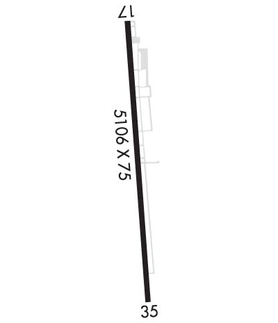
| Lat: N 3746.5 Long: W 09706.8 Elev: 1364 Var: -04 Longest Runway: 5106 | ||
| Clr Del: 125.0 AWOS: 118.3 CTAF: 123.07 | ||
| ||||||
| ||||||
|
| Rwy | Rwy | |||||||
| 5106x75 | 4864' | 5106x75 | 5106' | |||||
| Runway ID | Single Wheel | Double Wheel | Double Tandem Wheel | Dual Double Wheel |
| 17/35 | N/A | N/A | N/A | N/A |
| These numbers are Advisory and are not limits. The Airport Manager should have more accurate Weight Limits | ||||
 Airport Diagram might not be current. | |
| Facility Name: | LLOYD STEARMAN FLD |
| City Name: | BENTON |
| County: | BUTLER |
| State abbrev: | KS |
| State Name: | KANSAS |
| Ownership: | PRIVATELY OWNED |
| Use: | OPEN TO THE PUBLIC |
| Owner's Name: | BENTON AIRPARK INC.; RESIDENTIAL AIRPARK OWNER LIVES ON ARPT. |
| Address: | 14789 SOUTHWEST 30TH. STREET |
| BENTON, KS 67017 | |
| Owner's Phone: | 316-778-1035 |
| Manager's Name: | DWAYNE CLEMENS |
| Address: | 14789 SOUTHWEST 30TH. STREET |
| BENTON, KS 67017 | |
| Phone: | 316-648-0132 |
| FAA Region: | CENTRAL |
| FAA Field Office: | NONE |
| Date | Sunrise | Sunset |
|---|---|---|
| 09/24/21 Friday | 7:18 | 19:23 |
| 09/25/21 Saturday | 7:19 | 19:21 |
| 09/26/21 Sunday | 7:19 | 19:20 |
| 09/27/21 Monday | 7:20 | 19:18 |
| 09/28/21 Tuesday | 7:21 | 19:16 |
| 09/29/21 Wednesday | 7:22 | 19:15 |
| 09/30/21 Thursday | 7:23 | 19:13 |
| 10/01/21 Friday | 7:24 | 19:12 |
| 10/02/21 Saturday | 7:25 | 19:10 |
| 10/03/21 Sunday | 7:26 | 19:09 |
| 10/04/21 Monday | 7:26 | 19:07 |
| 10/05/21 Tuesday | 7:27 | 19:06 |
| 10/06/21 Wednesday | 7:28 | 19:04 |
| 10/07/21 Thursday | 7:29 | 19:03 |
| Airport Attendance Schedule | 7 Days A Week 0700-2300 |
| Airport Status | OPERATIONAL (This Status can change at any time - please check NOTAMS) |
| Airport Lighting Schedule | ACTVT HIRL RY 17/35 AND PAPI RYS 17 & 35 - 123.075 |
| Airport Storage Available | Tie Downs, Hanger |
| Extra Services Available | Flight Instruction, Aircraft Rental |
| Wind Indicator | YES - (lighted) |
| Control Tower | NO |
| CTAF Frequency | 123.075 |
| Unicom Frequency | 123.075; FOR CLNC DLVY CTC ICT APCH ON FREQ 134.8 OR CALL 316-946-0064. |
| Rotating Beacon Color | CLEAR-GREEN (Light Land Airport) |
| Segmented Circle | NO |
| Landing Fee | NO |
| Airport Inspected | STATE - performed by STATE AERONAUTICAL PERSONNEL |
| Inspection Date | 07/02/2020 |
| Type of Fuel Available | Grade 100LL, JET A (freeze point -40C); -1024 HR CREDIT CARD, FOR JET A CALL MGR 316-648-0132. |
| Airframe Repair Service | MAJOR |
| Power Plant Repair Service | MAJOR |
| Latitude | N3746.5 |
| Longitude | W09706.8 (ESTIMATED) |
| Arpt Elevation | 1364ft (SURVEYED) |
| Magnetic Variation | 04E |
| 1 miles SW | of BENTON |
| Traffic Pattern Altitude | |
| Sectional Chart | WICHITA |
| Operations (Reported) | Yearly | Avg. Daily |
|---|---|---|
| General Aviation Transient | 4500 | 12 |
| General Aviation Local | 22000 | 60 |
| Air Taxi | 425 | 1 |
| Commerical | 0 | 0 |
| Commuter | 0 | 0 |
| Military | 18500 | 51 |
| Aircraft based on Field | |
|---|---|
| General Aviation Singles | 185 |
| General Aviation Multi | 20 |
| Jet Aircraft | 12 |
| General Aviation Helicopters | 2 |
| Military Aircraft | 0 |
| Gliders | 0 |
| Ultralights | 0 |
| FSS on field | NO |
| FSS tie-in | WICHITA |
| FSS Phone | 1-800-WX-BRIEF |
| Who issues Notams | ICT |
| Notam D service at airport | YES |
| ARTCC Name | KANSAS CITY |
| Airport Certification | |
| Aircraft Rescue & Firefighting Index | None |
| Airport of Entry | No |
| Custom Landing Rights | No |
| Joint Civil/Military | No |
| Military Landing rights | No |
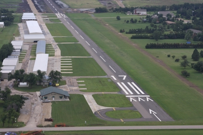
| RY 17/35 HAS BEEN WIDENED FROM 60' TO 75'. |
| 70' WIDE CONCRETE TWY TURN OFF ADDED MIDFIELD. |
| FOR CD CTC WICHITA APCH AT 316-350-1520. |
| TURF OPS WEST OF RY. |
| FOR ASSISTANCE AFT HRS CALL 316-648-0132 OR NRS POSTED AT FBO. |
| WARBIRD, ANTIQUE & HELICOPTER OPS ON & INVOF ARPT. |
| UNCONTROLLED VEH TFC INVOF HANGARS & ON TWYS. ACFT BACK TAXI ON RY WHEN ABLE. |
| ULTRALIGHT ACFT PPR. |
| TWIN AND LARGER ACFT BACK TAXI ON RY. |
Airport Communications & Frequencies:
| ||||||||||||||||
| Runway: 17 | Runway: 35 | ||
| Mag heading: | 172° | Mag heading: | 352° |
| Rwy Slope: | -.29% Down | Rwy Slope: | .29% Up |
| Approach: | Approach: | ||
| Pattern: | Right Traffic | Pattern: | Left Traffic |
| Markings: | BASIC | Markings: | BASIC |
| Marking Condition: | GOOD | Marking Condition: | GOOD |
| Arresting Dev: | Arresting Dev: | ||
| Lat & Long: | N3746.9 W09706.8 | Lat. & Long.: | N3746.0 W09706.8 |
| Elev: | 1364.1 ft. MSL | Elev: | 1349.1 ft. MSL |
| TCH: | 33 ft. AGL | TCH: | 32 ft. AGL |
| Visual Glide Path: | 3.00 degrees | Visual Glide Path: | 3.00 degrees |
| Displaced Threshold: | 242 feet | Displaced Threshold: | No |
| Touchdown Zone: | YES | Touchdown Zone: | YES |
| Touchdown Elev.: | 1363.1 feet | Touchdown Elev.: | 1350.7 feet |
| Visual Glide Slope: | 2-Light PAPI on LEFT side of Runway | Visual Glide Slope: | 2-Light PAPI on LEFT side of Runway |
| RVR Equipment: | RVR Equipment: | ||
| RVV Equipment: | NO | RVV Equipment: | NO |
| Approach Lights: | Approach Lights: | ||
| REIL: | NO | REIL: | NO |
| Centerline Lights: | NO | Centerline Lights: | NO |
| Touchdown lights: | NO | Touchdown lights: | NO |
| Runway Category: | Runway with a Non-precision Approach having visibility minimums greater than 3/4 mile | Runway Category: | Runway with a Visual Approach |
| Declared Distances: | Declared Distances: | ||
| Obstructions: | TREES | Obstructions: | TREES |
| Marked: | NOT Marked/Lighted | Marked: | NOT Marked/Lighted |
| Clearance slope: | 26:1; APCH RATIO 18:1 OVER +15 FT ROAD 284 FT FROM DSPLCD THLD. | Clearance slope: | 35:1; RY 35 APCH RATIO 13:1 OVER + 18 FT ROAD 247 FT FM DSPLD THLD. |
| Obstruction height: | 30 feet AGL | Obstruction height: | 35 feet AGL |
| Dist. from runway: | 980 feet | Dist. from runway: | 1400 feet |
| Centerline offset: | 186 left of centerline | Centerline offset: | |
| Comments: | 15 FT ROAD 40 FT FM RY END. | Comments: | 18 FT ROAD 157 FT FM RY END. |
Thanks for using FltPlan.com
all rights reserved © 1999-2021 by Flight Plan LLC