| GRAND VIEW AVIATION KREMMLING CO |
| |
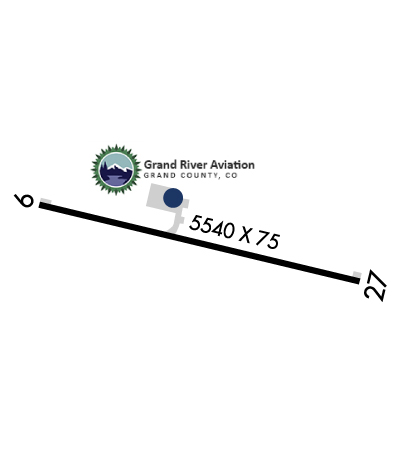
| Lat: N 4003.2 Long: W 10622.1 Elev: 7416 Var: -09 Longest Runway: 5540 | ||
| AWOS: 118.42 CTAF: 122.8 | ||
| ||||||||||||||||||||||||||||||||||||||||||||||||||||||||||||||||||||
| ||||||||||||||||||||||||||||||||||||||||||||||||||||||||||||||||||||
| ||||||||||||||||||||||||||||||||||||||||||||||||||||||||||||||||||||
| Rwy | Rwy | |||||||
| 5540x75 | 5540' | 5540x75 | 5540' | |||||
| Runway ID | Single Wheel | Double Wheel | Double Tandem Wheel | Dual Double Wheel |
| 09/27 | 46,000 | 68,000 | N/A | N/A |
| These numbers are Advisory and are not limits. The Airport Manager should have more accurate Weight Limits | ||||
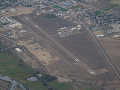
 Airport Diagram might not be current. | |
| Facility Name: | MC ELROY AIRFIELD |
| City Name: | KREMMLING |
| County: | GRAND |
| State abbrev: | CO |
| State Name: | COLORADO |
| Ownership: | PUBLICLY OWNED |
| Use: | OPEN TO THE PUBLIC |
| Owner's Name: | GRAND COUNTY |
| Address: | P.O. BOX 264 |
| HOT SULPHUR SPRINGS, CO 80451 | |
| Owner's Phone: | 970-725-3347 |
| Manager's Name: | JOSHUA SCHROEDER |
| Address: | P.O. BOX 264 |
| HOT SULPHUR SPRINGS, CO 80451 | |
| Phone: | 970-887-2123 |
| FAA Region: | NORTHWEST MOUNTAIN |
| FAA Field Office: | DEN |
| Date | Sunrise | Sunset |
|---|---|---|
| 04/27/25 Sunday | 6:11 | 19:56 |
| 04/28/25 Monday | 6:09 | 19:57 |
| 04/29/25 Tuesday | 6:08 | 19:58 |
| 04/30/25 Wednesday | 6:07 | 19:59 |
| 05/01/25 Thursday | 6:06 | 20:00 |
| 05/02/25 Friday | 6:04 | 20:01 |
| 05/03/25 Saturday | 6:03 | 20:02 |
| 05/04/25 Sunday | 6:02 | 20:03 |
| 05/05/25 Monday | 6:01 | 20:04 |
| 05/06/25 Tuesday | 6:00 | 20:05 |
| 05/07/25 Wednesday | 5:58 | 20:06 |
| 05/08/25 Thursday | 5:57 | 20:07 |
| 05/09/25 Friday | 5:56 | 20:08 |
| 05/10/25 Saturday | 5:55 | 20:09 |
| Airport Attendance Schedule | 7 Days A Week 0800-1730 |
| Airport Status | OPERATIONAL (This Status can change at any time - please check NOTAMS) |
| Airport Lighting Schedule | ACTVT REIL RWY 09 & 27; PAPI RWY 09 & 27; MIRL RWY 09/27 - CTAF. |
| Airport Storage Available | Tie Downs, Hanger |
| Extra Services Available | Flight Instruction, Aircraft Rental |
| Wind Indicator | YES - (lighted) |
| Control Tower | NO |
| CTAF Frequency | 122.800 |
| Unicom Frequency | 122.800 |
| Rotating Beacon Color | WG |
| Segmented Circle | YES |
| Landing Fee | NO |
| Airport Inspected | STATE - performed by STATE AERONAUTICAL PERSONNEL |
| Inspection Date | 05/16/2022 |
| Type of Fuel Available | Grade 100LL, JET A (freeze point -40C); -1024 HR FUEL SVC - CREDIT CARD. |
| Airframe Repair Service | NONE |
| Power Plant Repair Service | NONE |
| Latitude | N4003.2 |
| Longitude | W10622.1 (ESTIMATED) |
| Arpt Elevation | 7415ft (SURVEYED) |
| Magnetic Variation | 09E |
| 1 miles E | of KREMMLING |
| Traffic Pattern Altitude | |
| Sectional Chart | CHEYENNE |
| Operations (Reported) | Yearly | Avg. Daily |
|---|---|---|
| General Aviation Transient | 0 | 0 |
| General Aviation Local | 0 | 0 |
| Air Taxi | 0 | 0 |
| Commerical | 0 | 0 |
| Commuter | 0 | 0 |
| Military | 0 | 0 |
| Aircraft based on Field | |
|---|---|
| General Aviation Singles | 0 |
| General Aviation Multi | 0 |
| Jet Aircraft | 0 |
| General Aviation Helicopters | 0 |
| Military Aircraft | 0 |
| Gliders | 0 |
| Ultralights | 0 |
| FSS on field | NO |
| FSS tie-in | DENVER |
| FSS Phone | 1-800-WX-BRIEF |
| Who issues Notams | 20V |
| Notam D service at airport | YES |
| ARTCC Name | DENVER |
| Airport Certification | |
| Aircraft Rescue & Firefighting Index | None |
| Airport of Entry | No |
| Custom Landing Rights | No |
| Joint Civil/Military | No |
| Military Landing rights | No |
| NATIONAL PLAN OF INTEGRATED AIRPORT SYSTEMS (NPIAS) |
| GRANT AGREEMENTS UNDER FAAP/ADAP/AIP |
| ASSURANCES PURSUANT TO TITLE VI, CIVIL RIGHTS ACT OF 1964 |
| RWY 09 HAS 4 FT FENCE 441 FT FM AND PARL TO THLD, 30 FT LGT POLES AT RODEO ARENA APRXLY 900 FT FM EXTDD CNTRLN. |
| MTUS TRRN SRNDS ARPT. |
| COLD TEMPERATURE AIRPORT. ALTITUDE CORRECTION REQUIRED AT OR BELOW -18C. |
Airport Communications & Frequencies:
| |||||||||
| Runway: 09 | Runway: 27 | ||
| Mag heading: | 95° | Mag heading: | 275° |
| Rwy Slope: | .27% Up | Rwy Slope: | -.27% Down |
| Approach: | Approach: | ||
| Pattern: | Left Traffic | Pattern: | Right Traffic |
| Markings: | NONPRECISION INSTRUMENT | Markings: | NONPRECISION INSTRUMENT |
| Marking Condition: | GOOD | Marking Condition: | GOOD |
| Arresting Dev: | Arresting Dev: | ||
| Lat & Long: | N4003.3 W10622.7 | Lat. & Long.: | N4003.1 W10621.6 |
| Elev: | 7400.4 ft. MSL | Elev: | 7415.2 ft. MSL |
| TCH: | 43 ft. AGL | TCH: | 44 ft. AGL |
| Visual Glide Path: | 4.00 degrees | Visual Glide Path: | 3.00 degrees |
| Displaced Threshold: | No | Displaced Threshold: | No |
| Touchdown Zone: | YES | Touchdown Zone: | YES |
| Touchdown Elev.: | 7408.3 feet | Touchdown Elev.: | 7415.7 feet |
| Visual Glide Slope: | 2-Light PAPI on LEFT side of Runway; PAPI UNUSBL BYD 3.5 NM. | Visual Glide Slope: | 2-Light PAPI on LEFT side of Runway |
| RVR Equipment: | RVR Equipment: | ||
| RVV Equipment: | NO | RVV Equipment: | NO |
| Approach Lights: | Approach Lights: | ||
| REIL: | YES | REIL: | YES |
| Centerline Lights: | NO | Centerline Lights: | NO |
| Touchdown lights: | NO | Touchdown lights: | NO |
| Runway Category: | Runway with a Visual Approach | Runway Category: | Runway with a Visual Approach |
| Declared Distances: | Declared Distances: | ||
| Obstructions: | FENCE | Obstructions: | HILL |
| Marked: | NOT Marked/Lighted | Marked: | NOT Marked/Lighted |
| Clearance slope: | 28:1 | Clearance slope: | 32:1 |
| Obstruction height: | 8 feet AGL | Obstruction height: | 76 feet AGL |
| Dist. from runway: | 426 feet | Dist. from runway: | 2697 feet |
| Centerline offset: | Centerline offset: | 371 feet left of centerline | |
| Comments: | Comments: |
Thanks for using FltPlan.com
all rights reserved © 1999-2025 by Flight Plan LLC