
| DELAWARE AIRPARK DOVER/CHESWOLD DE |
| |
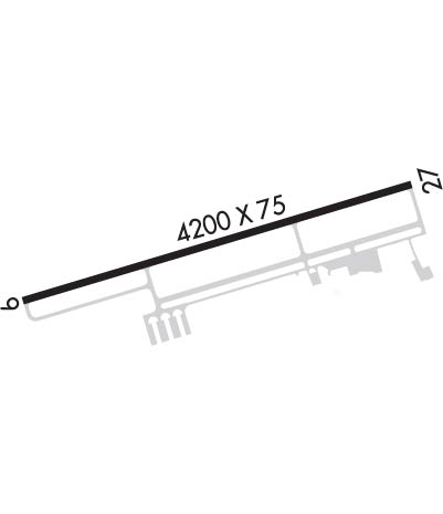
| Lat: N 3913.1 Long: W 07536.0 Elev: 55 Var: +12 Longest Runway: 4201 | ||
| Clr Del: 125.55 CTAF: 123.07 | ||
| ||||||||||||||||||||||||||||||||||||||||||||
| ||||||||||||||||||||||||||||||||||||||||||||
| Rwy | Rwy | |||||||
| 4201x75 | 4201' | 4201x75 | 4201' | |||||
| Runway ID | Single Wheel | Double Wheel | Double Tandem Wheel | Dual Double Wheel |
| 09/27 | 38,500 | 56,500 | N/A | N/A |
| These numbers are Advisory and are not limits. The Airport Manager should have more accurate Weight Limits | ||||
 Airport Diagram might not be current. | |
| Facility Name: | DELAWARE AIRPARK |
| City Name: | DOVER/CHESWOLD |
| County: | KENT |
| State abbrev: | DE |
| State Name: | DELAWARE |
| Ownership: | PUBLICLY OWNED |
| Use: | OPEN TO THE PUBLIC |
| Owner's Name: | DELAWARE DEPT OF TRANSPORTATION |
| Address: | 127 DURHAM LANE |
| DOVER, DE 19904 | |
| Owner's Phone: | (302) 571-6312 |
| Manager's Name: | BROOKLYN QUIGLEY |
| Address: | 127 DURHAM LANE |
| DOVER, DE 19904 | |
| Phone: | 302-535-5980 |
| FAA Region: | EASTERN |
| FAA Field Office: | HAR |
| Date | Sunrise | Sunset |
|---|---|---|
| 04/26/25 Saturday | 6:11 | 19:50 |
| 04/27/25 Sunday | 6:09 | 19:51 |
| 04/28/25 Monday | 6:08 | 19:52 |
| 04/29/25 Tuesday | 6:07 | 19:53 |
| 04/30/25 Wednesday | 6:06 | 19:54 |
| 05/01/25 Thursday | 6:04 | 19:55 |
| 05/02/25 Friday | 6:03 | 19:56 |
| 05/03/25 Saturday | 6:02 | 19:57 |
| 05/04/25 Sunday | 6:01 | 19:58 |
| 05/05/25 Monday | 6:00 | 19:59 |
| 05/06/25 Tuesday | 5:58 | 20:00 |
| 05/07/25 Wednesday | 5:57 | 20:01 |
| 05/08/25 Thursday | 5:56 | 20:02 |
| 05/09/25 Friday | 5:55 | 20:03 |
| Airport Attendance Schedule | 7 Days A Week 0830-1630 |
| Airport Status | OPERATIONAL (This Status can change at any time - please check NOTAMS) |
| Airport Lighting Schedule | ACTVT REIL RWY 09 & 27; MIRL RWY 09/27 - CTAF . |
| Airport Storage Available | NONE |
| Extra Services Available | Crop Dusting, Flight Instruction, Aircraft Rental |
| Wind Indicator | YES - (lighted) |
| Control Tower | NO |
| CTAF Frequency | 123.075 |
| Unicom Frequency | 123.075 |
| Rotating Beacon Color | WG |
| Segmented Circle | YES |
| Landing Fee |
| Airport Inspected | STATE - performed by PRIVATE CONTRACT PERSONNEL |
| Inspection Date | 09/12/2023 |
| Type of Fuel Available | Grade 100LL; -1024 HR SELF-SERVICE CREDIT CARD FUEL AVBL. |
| Airframe Repair Service | NONE |
| Power Plant Repair Service | NONE |
| Latitude | N3913.1 |
| Longitude | W07536.0 (ESTIMATED) |
| Arpt Elevation | 55ft (SURVEYED) |
| Magnetic Variation | 12W |
| 1 miles W | of DOVER/CHESWOLD |
| Traffic Pattern Altitude | |
| Sectional Chart | WASHINGTON |
| Operations (Reported) | Yearly | Avg. Daily |
|---|---|---|
| General Aviation Transient | 0 | 0 |
| General Aviation Local | 0 | 0 |
| Air Taxi | 0 | 0 |
| Commerical | 0 | 0 |
| Commuter | 0 | 0 |
| Military | 0 | 0 |
| Aircraft based on Field | |
|---|---|
| General Aviation Singles | 0 |
| General Aviation Multi | 0 |
| Jet Aircraft | 0 |
| General Aviation Helicopters | 0 |
| Military Aircraft | 0 |
| Gliders | 0 |
| Ultralights | 0 |
| FSS on field | NO |
| FSS tie-in | MILLVILLE |
| FSS Phone | 1-800-WX-BRIEF |
| Who issues Notams | MIV |
| Notam D service at airport | YES |
| ARTCC Name | WASHINGTON |
| Airport Certification | |
| Aircraft Rescue & Firefighting Index | None |
| Airport of Entry | No |
| Custom Landing Rights | No |
| Joint Civil/Military | No |
| Military Landing rights | No |
| NATIONAL PLAN OF INTEGRATED AIRPORT SYSTEMS (NPIAS) |
| ACFT UN OPS DUE TO SIZE OR FAC ALTN IS DOVER AFB CIV AIR TRML, PPR RQR (302) 571- 6375. |
| TRAN ACFT PRKG N TRML BLDG. ADDNLTRAN PRKG ON APN W OF T HNGRS. E APN CLSD TO TRAN ACFT PRKG. |
| DEER AND BIRDS ON AND INVOF ARPT. |
| MOWING OPS CONDUCTED 0700-1500 APR-OCT. |
| ARPT CONDS UNMON BTN 1630-0830. |
| ACFT NOT VISIBLE ON OPPOSITE END OF RWY DUE TO GRADIENT. |
| FOR CD CTC WASHINGTON ARTCC AT 703-771-3587. |
| SGFNT FIXED WING AND HELI ACFT FLT TRG INVOF AIRPARK. |
| RWY 27 CALM WIND RWY. |
Airport Communications & Frequencies:
| ||||||||||||||||
| Runway: 09 | Runway: 27 | ||
| Mag heading: | 85° | Mag heading: | 265° |
| Rwy Slope: | -.08% Down | Rwy Slope: | .08% Up |
| Approach: | Approach: | ||
| Pattern: | Left Traffic | Pattern: | Left Traffic |
| Markings: | NONPRECISION INSTRUMENT | Markings: | NONPRECISION INSTRUMENT |
| Marking Condition: | GOOD | Marking Condition: | GOOD |
| Arresting Dev: | Arresting Dev: | ||
| Lat & Long: | N3913.0 W07536.5 | Lat. & Long.: | N3913.2 W07535.6 |
| Elev: | 48.6 ft. MSL | Elev: | 45.2 ft. MSL |
| TCH: | 43 ft. AGL | TCH: | 43 ft. AGL |
| Visual Glide Path: | 3.00 degrees | Visual Glide Path: | 3.00 degrees |
| Displaced Threshold: | No | Displaced Threshold: | No |
| Touchdown Zone: | YES | Touchdown Zone: | YES |
| Touchdown Elev.: | 55.2 feet | Touchdown Elev.: | 55.2 feet |
| Visual Glide Slope: | 2-Light PAPI on LEFT side of Runway | Visual Glide Slope: | 2-Light PAPI on LEFT side of Runway |
| RVR Equipment: | RVR Equipment: | ||
| RVV Equipment: | NO | RVV Equipment: | NO |
| Approach Lights: | Approach Lights: | ||
| REIL: | YES | REIL: | YES |
| Centerline Lights: | NO | Centerline Lights: | NO |
| Touchdown lights: | NO | Touchdown lights: | NO |
| Runway Category: | Runway with a Non-precision Approach | Runway Category: | Runway with a Non-precision Approach |
| Declared Distances: | Declared Distances: | ||
| Obstructions: | 94 FT TREE 0.3 NM WEST OF RWY. | Obstructions: | 57 FT PWR LN 0.2 NM EAST OF RWY. |
| Marked: | NOT Marked/Lighted | Marked: | NOT Marked/Lighted |
| Clearance slope: | 20:1 | Clearance slope: | 20:1 |
| Obstruction height: | Obstruction height: | ||
| Dist. from runway: | Dist. from runway: | ||
| Centerline offset: | Centerline offset: | ||
| Comments: | Comments: |
Thanks for using FltPlan.com
all rights reserved © 1999-2025 by Flight Plan LLC
