
| COLORADO PLAINS RGNL AKRON CO |
| |
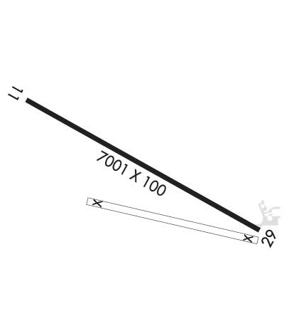
| Lat: N 4010.5 Long: W 10313.3 Elev: 4716 Var: -10 Longest Runway: 7001 | ||
| Clr Del: 122.2 RCO AWOS: 135.47 CTAF: 122.8 | ||
| ||||||||||||||||||||||||||||||||||||||||||||
| ||||||||||||||||||||||||||||||||||||||||||||
| ||||||||||||||||||||||||||||||||||||||||||||
| Rwy | Rwy | |||||||
| 7001x100 | 7001' | 7001x100 | 7001' | |||||
| Runway ID | Single Wheel | Double Wheel | Double Tandem Wheel | Dual Double Wheel |
| 11/29 | 65,000 | 85,000 | 125,000 | N/A |
| These numbers are Advisory and are not limits. The Airport Manager should have more accurate Weight Limits | ||||
 Airport Diagram might not be current. | |
| Facility Name: | COLORADO PLAINS RGNL |
| City Name: | AKRON |
| County: | WASHINGTON |
| State abbrev: | CO |
| State Name: | COLORADO |
| Ownership: | PUBLICLY OWNED |
| Use: | OPEN TO THE PUBLIC |
| Owner's Name: | TOWN OF AKRON |
| Address: | CITY HALL, P.O. BOX P |
| AKRON, CO 80720 | |
| Owner's Phone: | 970-345-2624 |
| Manager's Name: | RANDY HAYES |
| Address: | PO BOX O |
| AKRON, CO 80720 | |
| Phone: | 970-345-2397 |
| FAA Region: | NORTHWEST MOUNTAIN |
| FAA Field Office: | DEN |
| Date | Sunrise | Sunset |
|---|---|---|
| 03/15/25 Saturday | 7:05 | 19:00 |
| 03/16/25 Sunday | 7:03 | 19:01 |
| 03/17/25 Monday | 7:02 | 19:02 |
| 03/18/25 Tuesday | 7:00 | 19:03 |
| 03/19/25 Wednesday | 6:58 | 19:04 |
| 03/20/25 Thursday | 6:57 | 19:05 |
| 03/21/25 Friday | 6:55 | 19:06 |
| 03/22/25 Saturday | 6:53 | 19:07 |
| 03/23/25 Sunday | 6:52 | 19:08 |
| 03/24/25 Monday | 6:50 | 19:09 |
| 03/25/25 Tuesday | 6:49 | 19:10 |
| 03/26/25 Wednesday | 6:47 | 19:11 |
| 03/27/25 Thursday | 6:45 | 19:12 |
| 03/28/25 Friday | 6:44 | 19:13 |
| Airport Attendance Schedule | 7 Days A Week 0800-1700; FOR FUEL WHEN ARPT UNATNDD CALL 970-345-2397. |
| Airport Status | OPERATIONAL (This Status can change at any time - please check NOTAMS) |
| Airport Lighting Schedule | ACTVT REIL RWY 11 & 29; PAPI RWY 11 & 29; MIRL RWY 11/29 - CTAF. |
| Airport Storage Available | Tie Downs, Hanger |
| Extra Services Available | Crop Dusting, Flight Instruction |
| Wind Indicator | YES - (lighted) |
| Control Tower | NO |
| CTAF Frequency | 122.800 |
| Unicom Frequency | 122.800 |
| Rotating Beacon Color | WG |
| Segmented Circle | YES |
| Landing Fee | NO |
| Airport Inspected | STATE - performed by STATE AERONAUTICAL PERSONNEL |
| Inspection Date | 06/15/2023 |
| Type of Fuel Available | Grade 100LL, JET A-1 (freeze point -50C); -1024 HR SELF SERVE 100LL AVBL WITH CREDIT CARD. |
| Airframe Repair Service | MAJOR |
| Power Plant Repair Service | MAJOR |
| Latitude | N4010.5 |
| Longitude | W10313.3 (ESTIMATED) |
| Arpt Elevation | 4716ft (SURVEYED) |
| Magnetic Variation | 10E |
| 1 miles N | of AKRON |
| Traffic Pattern Altitude | |
| Sectional Chart | CHEYENNE |
| Operations (Reported) | Yearly | Avg. Daily |
|---|---|---|
| General Aviation Transient | 0 | 0 |
| General Aviation Local | 0 | 0 |
| Air Taxi | 0 | 0 |
| Commerical | 0 | 0 |
| Commuter | 0 | 0 |
| Military | 0 | 0 |
| Aircraft based on Field | |
|---|---|
| General Aviation Singles | 0 |
| General Aviation Multi | 0 |
| Jet Aircraft | 0 |
| General Aviation Helicopters | 0 |
| Military Aircraft | 0 |
| Gliders | 0 |
| Ultralights | 0 |
| FSS on field | NO |
| FSS tie-in | DENVER |
| FSS Phone | 1-800-WX-BRIEF |
| Who issues Notams | AKO |
| Notam D service at airport | YES |
| ARTCC Name | DENVER |
| Airport Certification | |
| Aircraft Rescue & Firefighting Index | None |
| Airport of Entry | No |
| Custom Landing Rights | No |
| Joint Civil/Military | No |
| Military Landing rights | YES |
| NATIONAL PLAN OF INTEGRATED AIRPORT SYSTEMS (NPIAS) |
| GRANT AGREEMENTS UNDER FAAP/ADAP/AIP |
| ASSURANCES PURSUANT TO TITLE VI, CIVIL RIGHTS ACT OF 1964 |
| EXTSV CROP SPRAYING OPNS IN THE AREA APR- OCT. |
| FOR CD IF UNA TO CTC ON FSS FREQ, CTC DENVER ARTCC AT 303-651-4257. |
Airport Communications & Frequencies:
| |||||||||
| Runway: 11 | Runway: 29 | ||
| Mag heading: | 109° | Mag heading: | 289° |
| Rwy Slope: | -.65% Down | Rwy Slope: | .65% Up |
| Approach: | Approach: | ||
| Pattern: | Left Traffic | Pattern: | Left Traffic |
| Markings: | NONPRECISION INSTRUMENT | Markings: | NONPRECISION INSTRUMENT |
| Marking Condition: | POOR; RWY 11 THLD MARKINGS WORN & FADED. | Marking Condition: | POOR; RWY 29 THLD MARKINGS WORN & FADED. |
| Arresting Dev: | Arresting Dev: | ||
| Lat & Long: | N4010.8 W10314.0 | Lat. & Long.: | N4010.3 W10312.7 |
| Elev: | 4716.0 ft. MSL | Elev: | 4670.8 ft. MSL |
| TCH: | 44 ft. AGL | TCH: | 43 ft. AGL |
| Visual Glide Path: | 3.00 degrees | Visual Glide Path: | 3.00 degrees |
| Displaced Threshold: | No | Displaced Threshold: | No |
| Touchdown Zone: | YES | Touchdown Zone: | YES |
| Touchdown Elev.: | 4716.0 feet | Touchdown Elev.: | 4682.7 feet |
| Visual Glide Slope: | 2-Light PAPI on LEFT side of Runway | Visual Glide Slope: | 2-Light PAPI on LEFT side of Runway |
| RVR Equipment: | RVR Equipment: | ||
| RVV Equipment: | NO | RVV Equipment: | NO |
| Approach Lights: | Approach Lights: | ||
| REIL: | YES | REIL: | YES |
| Centerline Lights: | NO | Centerline Lights: | NO |
| Touchdown lights: | NO | Touchdown lights: | NO |
| Runway Category: | Runway with a Visual Approach | Runway Category: | Runway with a Non-precision Approach having visibility minimums greater than 3/4 mile |
| Declared Distances: | Declared Distances: | ||
| Obstructions: | ROAD | Obstructions: | |
| Marked: | NOT Marked/Lighted | Marked: | |
| Clearance slope: | 33:1 | Clearance slope: | 50:1 |
| Obstruction height: | 24 feet AGL | Obstruction height: | |
| Dist. from runway: | 996 feet | Dist. from runway: | |
| Centerline offset: | 280 right of centerline | Centerline offset: | |
| Comments: | Comments: |
Thanks for using FltPlan.com
all rights reserved © 1999-2025 by Flight Plan LLC
