| LIMA ALLEN COUNTY LIMA OH |
| |
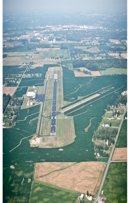
| Lat: N 4042.4 Long: W 08401.6 Elev: 975 Var: +06 Longest Runway: 6000 | ||
| CTAF: 122.7 | ||
| ||||||||||||||||||||||||||||||||||||||||||||
| ||||||||||||||||||||||||||||||||||||||||||||
| ||||||||||||||||||||||||||||||||||||||||||||
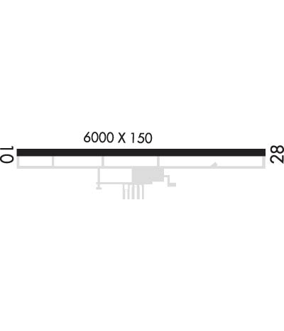
| Rwy | Rwy | |||||||
| 6000x150 | 6000' | 6000x150 | 6000' | 109.30 - 276° | ||||
| Runway ID | Single Wheel | Double Wheel | Double Tandem Wheel | Dual Double Wheel |
| 10/28 | N/A | 60,000 | N/A | N/A |
| These numbers are Advisory and are not limits. The Airport Manager should have more accurate Weight Limits | ||||
 Airport Diagram might not be current. | |
| Facility Name: | LIMA ALLEN COUNTY |
| City Name: | LIMA |
| County: | ALLEN |
| State abbrev: | OH |
| State Name: | OHIO |
| Ownership: | PUBLICLY OWNED |
| Use: | OPEN TO THE PUBLIC |
| Owner's Name: | ALLEN COUNTY RGNL ARPT AUTH |
| Address: | PO BOX 1401 |
| LIMA, OH 45802-1401 | |
| Owner's Phone: | 419-227-3225 |
| Manager's Name: | JOSH TATTRIE |
| Address: | 700 AIRPORT DR |
| LIMA, OH 45804-4201 | |
| Phone: | 419-227-3225; CELL 567-712-9529. |
| FAA Region: | GREAT LAKES |
| FAA Field Office: | DET |
| Date | Sunrise | Sunset |
|---|---|---|
| 04/27/25 Sunday | 6:40 | 20:28 |
| 04/28/25 Monday | 6:39 | 20:29 |
| 04/29/25 Tuesday | 6:38 | 20:30 |
| 04/30/25 Wednesday | 6:36 | 20:31 |
| 05/01/25 Thursday | 6:35 | 20:32 |
| 05/02/25 Friday | 6:34 | 20:33 |
| 05/03/25 Saturday | 6:33 | 20:34 |
| 05/04/25 Sunday | 6:31 | 20:35 |
| 05/05/25 Monday | 6:30 | 20:36 |
| 05/06/25 Tuesday | 6:29 | 20:37 |
| 05/07/25 Wednesday | 6:28 | 20:38 |
| 05/08/25 Thursday | 6:27 | 20:39 |
| 05/09/25 Friday | 6:25 | 20:40 |
| 05/10/25 Saturday | 6:24 | 20:41 |
| Airport Attendance Schedule | MON-FRI 0800-1700, SAT 0900-1600, SUN 1300-1700; UNATNDD NEW YEARS DAY, EASTER, THANKSGIVING, & CHRISTMAS. |
| Airport Status | OPERATIONAL (This Status can change at any time - please check NOTAMS) |
| Airport Lighting Schedule | ACTVT REIL RWY 10 & 28; HIRL RWY 10/28 - CTAF. PAPI RWY 10 & 28 OPR CONSLY. |
| Airport Storage Available | Tie Downs, Hanger |
| Extra Services Available | Avionics, Flight Instruction, Aircraft Rental, Aircraft Sales |
| Wind Indicator | YES - (lighted) |
| Control Tower | NO |
| CTAF Frequency | 122.700 |
| Unicom Frequency | 122.700 |
| Rotating Beacon Color | WG |
| Segmented Circle | YES |
| Landing Fee | YES; LDG FEE FOR TURBINE ACFT WAIVED WITH FUEL PURCHASE. OVNGT FEES ADNL. |
| Airport Inspected | STATE - performed by STATE AERONAUTICAL PERSONNEL |
| Inspection Date | 08/11/2022 |
| Type of Fuel Available | Grade 100LL, JET A-1 (icing inhibitor, freeze point -50C); -A1CALL AHD FOR FUEL AFT HRS SUBJ CALL-IN FEE.; -10FUEL AVBL H24. |
| Airframe Repair Service | MAJOR |
| Power Plant Repair Service | MAJOR |
| Latitude | N4042.4 |
| Longitude | W08401.6 (ESTIMATED) |
| Arpt Elevation | 975ft (SURVEYED) |
| Magnetic Variation | 06W |
| 5 miles SE | of LIMA |
| Traffic Pattern Altitude | |
| Sectional Chart | DETROIT |
| Operations (Reported) | Yearly | Avg. Daily |
|---|---|---|
| General Aviation Transient | 0 | 0 |
| General Aviation Local | 0 | 0 |
| Air Taxi | 0 | 0 |
| Commerical | 0 | 0 |
| Commuter | 0 | 0 |
| Military | 0 | 0 |
| Aircraft based on Field | |
|---|---|
| General Aviation Singles | 0 |
| General Aviation Multi | 0 |
| Jet Aircraft | 0 |
| General Aviation Helicopters | 0 |
| Military Aircraft | 0 |
| Gliders | 0 |
| Ultralights | 0 |
| FSS on field | NO |
| FSS tie-in | DAYTON |
| FSS Phone | 1-800-WX-BRIEF |
| Who issues Notams | AOH |
| Notam D service at airport | YES |
| ARTCC Name | INDIANAPOLIS |
| Airport Certification | |
| Aircraft Rescue & Firefighting Index | None |
| Airport of Entry | No |
| Custom Landing Rights | No |
| Joint Civil/Military | No |
| Military Landing rights | YES |
| NATIONAL PLAN OF INTEGRATED AIRPORT SYSTEMS (NPIAS) |
| GRANT AGREEMENTS UNDER FAAP/ADAP/AIP |
| ASSURANCES PURSUANT TO TITLE VI, CIVIL RIGHTS ACT OF 1964 |
| FOR CD CTC COLUMBUS APCH ON FREQ, IF UNA CALL 614-338-8537. |
| DEER, BIRDS, & OTR WILDLIFE ON & INVOF ARPT. |
Airport Communications & Frequencies:
| ||||||||||||||
| Runway: 10 | Runway: 28 | ||
| Mag heading: | 96° | Mag heading: | 276° |
| Rwy Slope: | .43% Up | Rwy Slope: | -.43% Down |
| Approach: | Approach: | ILS | |
| Pattern: | Left Traffic | Pattern: | Left Traffic |
| Markings: | NONPRECISION INSTRUMENT | Markings: | PRECISION INSTRUMENT |
| Marking Condition: | GOOD | Marking Condition: | GOOD |
| Arresting Dev: | Arresting Dev: | ||
| Lat & Long: | N4042.4 W08402.3 | Lat. & Long.: | N4042.4 W08401.0 |
| Elev: | 949.3 ft. MSL | Elev: | 975.3 ft. MSL |
| TCH: | 48 ft. AGL | TCH: | 49 ft. AGL |
| Visual Glide Path: | 3.00 degrees | Visual Glide Path: | 3.00 degrees |
| Displaced Threshold: | No | Displaced Threshold: | No |
| Touchdown Zone: | YES | Touchdown Zone: | YES |
| Touchdown Elev.: | 961.3 feet | Touchdown Elev.: | 975.3 feet |
| Visual Glide Slope: | 4-Light PAPI on LEFT side of Runway | Visual Glide Slope: | 4-Light PAPI on LEFT side of Runway |
| RVR Equipment: | RVR Equipment: | ||
| RVV Equipment: | NO | RVV Equipment: | NO |
| Approach Lights: | Approach Lights: | ||
| REIL: | YES | REIL: | YES |
| Centerline Lights: | NO | Centerline Lights: | NO |
| Touchdown lights: | NO | Touchdown lights: | NO |
| Runway Category: | Runway with a Non-precision Approach having visibility minimums greater than 3/4 mile | Runway Category: | Precision Instrument Runway |
| Declared Distances: | Declared Distances: | ||
| Obstructions: | TREES | Obstructions: | TREE |
| Marked: | NOT Marked/Lighted | Marked: | NOT Marked/Lighted |
| Clearance slope: | 26:1 | Clearance slope: | 33:1 |
| Obstruction height: | 73 feet AGL | Obstruction height: | 44 feet AGL |
| Dist. from runway: | 2156 feet | Dist. from runway: | 1687 feet |
| Centerline offset: | 105 left of centerline | Centerline offset: | 360 feet left of centerline |
| Comments: | Comments: |
Thanks for using FltPlan.com
all rights reserved © 1999-2025 by Flight Plan LLC