
| BOB HOPE BURBANK CA |
| |
| Lat: N 3412.0 Long: W 11821.5 Elev: 778 Var: -12 Longest Runway: 6886 | ||
| Clr Del: 118.0 Dept. ATIS: 134.5 Arr. ATIS: 134.5/135.12 Ground: 123.9 Tower: 118.7/132.32 | ||
| |||||||||||||||||||||||||||||||||||||||||||||||||||||||||||||||||||||
| |||||||||||||||||||||||||||||||||||||||||||||||||||||||||||||||||||||
| |||||||||||||||||||||||||||||||||||||||||||||||||||||||||||||||||||||
| |||||||||||||||||||||||||||||||||||||||||||||||||||||||||||||||||||||
| |||||||||||||||||||||||||||||||||||||||||||||||||||||||||||||||||||||
| Rwy | Rwy | |||||||
| 5802x150 | 5802' | 109.50 - 078° | 5802x150 | 5802' | ||||
| 6886x150 | 5977' | 6886x150 | 6536' | |||||
| Runway ID | Single Wheel | Double Wheel | Double Tandem Wheel | Dual Double Wheel |
| 08/26 | 120,000 | 201,000 | 352,000 | 839,000 |
| 15/33 | 120,000 | 201,000 | 352,000 | 839,000 |
| These numbers are Advisory and are not limits. The Airport Manager should have more accurate Weight Limits | ||||
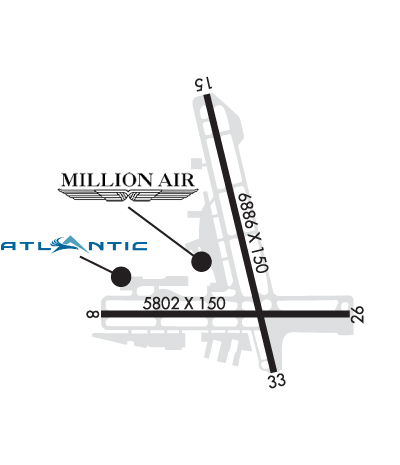 Airport Diagram might not be current. | |
| Facility Name: | BOB HOPE |
| City Name: | BURBANK |
| County: | LOS ANGELES |
| State abbrev: | CA |
| State Name: | CALIFORNIA |
| Ownership: | PUBLICLY OWNED |
| Use: | OPEN TO THE PUBLIC |
| Owner's Name: | BURBANK-GLENDALE-PASADENA APT |
| Address: | 2627 HOLLYWOOD WAY |
| BURBANK, CA 91505 | |
| Owner's Phone: | 818-840-8840 |
| Manager's Name: | MICHAEL CRANE, OPERATIONS MANAGER |
| Address: | 2627 HOLLYWOOD WAY |
| BURBANK, CA 91505 | |
| Phone: | (818) 565-1348 |
| FAA Region: | WESTERN-PACIFIC |
| FAA Field Office: | LAX |
| Date | Sunrise | Sunset |
|---|---|---|
| 09/24/21 Friday | 6:43 | 18:48 |
| 09/25/21 Saturday | 6:43 | 18:46 |
| 09/26/21 Sunday | 6:44 | 18:45 |
| 09/27/21 Monday | 6:45 | 18:43 |
| 09/28/21 Tuesday | 6:46 | 18:42 |
| 09/29/21 Wednesday | 6:46 | 18:41 |
| 09/30/21 Thursday | 6:47 | 18:39 |
| 10/01/21 Friday | 6:48 | 18:38 |
| 10/02/21 Saturday | 6:49 | 18:36 |
| 10/03/21 Sunday | 6:49 | 18:35 |
| 10/04/21 Monday | 6:50 | 18:34 |
| 10/05/21 Tuesday | 6:51 | 18:32 |
| 10/06/21 Wednesday | 6:52 | 18:31 |
| 10/07/21 Thursday | 6:52 | 18:30 |
| Airport Attendance Schedule | CONTINUOUS |
| Airport Status | OPERATIONAL (This Status can change at any time - please check NOTAMS) |
| Airport Lighting Schedule | |
| Airport Storage Available | Tie Downs, Hanger |
| Extra Services Available | Air Freight, Cargo Handling, Charter, Flight Instruction, Aircraft Rental, Aircraft Sales |
| Wind Indicator | YES - (lighted) |
| Control Tower | YES |
| CTAF Frequency | |
| Unicom Frequency | 122.950 |
| Rotating Beacon Color | CLEAR-GREEN (Light Land Airport) |
| Segmented Circle | NO |
| Landing Fee | NO |
| Airport Inspected | FEDERAL - performed by FAA AIRPORTS FIELD PERSONNEL |
| Inspection Date | 11/15/2018 |
| Type of Fuel Available | Grade 100LL, JET A (freeze point -40C), JET A |
| Airframe Repair Service | NONE |
| Power Plant Repair Service | NONE |
| Latitude | N3412.0 |
| Longitude | W11821.5 (ESTIMATED) |
| Arpt Elevation | 778ft (SURVEYED) |
| Magnetic Variation | 12E |
| 3 miles NW | of BURBANK |
| Traffic Pattern Altitude | |
| Sectional Chart | LOS ANGELES |
| Operations (Reported) | Yearly | Avg. Daily |
|---|---|---|
| General Aviation Transient | 28171 | 77 |
| General Aviation Local | 27157 | 74 |
| Air Taxi | 22190 | 61 |
| Commerical | 49467 | 136 |
| Commuter | 0 | 0 |
| Military | 539 | 1 |
| Aircraft based on Field | |
|---|---|
| General Aviation Singles | 22 |
| General Aviation Multi | 9 |
| Jet Aircraft | 39 |
| General Aviation Helicopters | 6 |
| Military Aircraft | 0 |
| Gliders | 0 |
| Ultralights | 0 |
| FSS on field | NO |
| FSS tie-in | HAWTHORNE |
| FSS Phone | 1-800-WX-BRIEF |
| Who issues Notams | BUR |
| Notam D service at airport | YES |
| ARTCC Name | LOS ANGELES |
| Airport Certification | AIRPORT RECEIVING SCHEDULED AIR CARRIER SERVICE FROM CARRIERS CERTIFICATED BY THE CIVIL AERONAUTICS BOARD |
| Aircraft Rescue & Firefighting Index | AIRPORT HAS A CERTIFICATE UNDER CFR PART 139 |
| Airport of Entry | No |
| Custom Landing Rights | YES |
| Joint Civil/Military | No |
| Military Landing rights | YES |
| NATIONAL PLAN OF INTEGRATED AIRPORT SYSTEMS (NPIAS) |
| GRANT AGREEMENTS UNDER FAAP/ADAP/AIP |
| ASSURANCES PURSUANT TO TITLE VI, CIVIL RIGHTS ACT OF 1964 |
| ACFT IN TFC PAT (1225 FT AGL) AT WHITEMAN AIRPARK 5 MI NW. |
| HANG GLIDER ACTIVITY BTN 5 & 10 NM NORTH OF ARPT 6000 FT AGL SR-SS. |
| TWY G RSTRD TO ACFT WITH WINGSPAN OF 95 FT OR LESS. |
| POWER ENGINE RUN-UPS FOR ACFT GTR THAN 1200 LBS PROHIBITED IN ALL AREAS EXC ON TWY D RUN-UP AREA OR AS COORDINATED WITH ATCT. |
| 14 FT BLAST FENCE 35 FT FM DEP END RY 15. |
| 14 FT BLAST FENCE 93 FT FM DEP END RY 33. |
| 8 FT BLAST FENCE 260 FT FM DEP END OF RY 26. |
| 14 FT BLAST FENCE 256 FT FROM DEP END RY 08. |
| TWY A RESTRICTED TO ACFT WITH WINGSPAN OF 171 FT OR LESS. |
| PILOTS SHOULD CALL AHEAD FOR ARPT NOISE RULES (818) 840-8840. |
| RSTRS AND FINES EFF 2200-0700 FOR STAGE 2 JETS, CERTAIN PROPS, RUN-UPS AND FLT TRG ACT, CALL (818) 840-8840 BFR OPRG. |
| HELICOPTER ARRIVALS RESTRICTED TO RY 08/26 AND 15/33. |
| TWY B RESTRICTED TO ACFT WITH WINGSPAN OF 79 FT OR LESS BEGINNING 300 FT NORTH OF TWY D AND CONTINUING NORTH. |
| NO GA ACFT PARKING AT TERMINAL RAMP. |
| ACFT WILL USE EASY PWR WHEN LVG ASGND GATE. CTN MUST BE USED WHEN TAXIING FM TRML AREA DUE TO CLOSE PROXIMITY TO THE TRML. PSNL AND GND EQUIP IN AREA. |
| ACFT WITH WINGSPAN GTR THAN 95 FT EXP BACK TAXI ON RWY 15/33 FOR A RWY 33 DEP. |
| ACFT RSTRD FM TAXIING SB PAST GATE B1 ON TERM RAMP. |
| ACFT WITH WINGSPAN GTR THAN 79 FT RSTRD FROM USING TWY C W OF TWY C8. |
| RWY 26 CLSD TO TKOF/JET ACFT WITH FOUR OR MORE ENGS. |
| X-BLEED STARTS PROHIBITED IN ALL NON-MOVMT AREAS INCLG THE AIRLINE TRML RAMP. ATC MAY APV X-BLEED STARTS ON TWY A NORTH OF TWY D, ALL OTHER REQS MUST BE COORDD AND APVD BY OPS. |
| BIRD ACTIVITY NORTH END RY 15/33 AND WEST END RY 08/26. |
| RWY 08 CLSD TKOF ACFT GTR THAN 12500 LBS. |
Airport Communications & Frequencies:
| |||||||||||||||||||||||||||||||||||||||||||||||||||||||||||||||||||||||||||||
| Runway: 08 | Runway: 26 | ||
| Mag heading: | 79° | Mag heading: | 259° |
| Rwy Slope: | -.52% Down | Rwy Slope: | .52% Up |
| Approach: | ILS | Approach: | |
| Pattern: | Right Traffic | Pattern: | Left Traffic |
| Markings: | PRECISION INSTRUMENT | Markings: | NONPRECISION INSTRUMENT |
| Marking Condition: | GOOD | Marking Condition: | GOOD |
| Arresting Dev: | EMAS; ENGINEERED MATERIAL ARRESTING SYSTEM (EMAS) 170 FT LENGTH BY 350 FT WIDTH LCTD AT THE DER 08. | Arresting Dev: | |
| Lat & Long: | N3411.9 W11822.1 | Lat. & Long.: | N3411.9 W11821.0 |
| Elev: | 727.4 ft. MSL | Elev: | 697.3 ft. MSL |
| TCH: | 72 ft. AGL | TCH: | |
| Visual Glide Path: | 3.00 degrees | Visual Glide Path: | |
| Displaced Threshold: | No | Displaced Threshold: | No |
| Touchdown Zone: | YES | Touchdown Zone: | YES |
| Touchdown Elev.: | 727.4 feet | Touchdown Elev.: | 716.3 feet |
| Visual Glide Slope: | 4-Light PAPI on LEFT side of Runway | Visual Glide Slope: | |
| RVR Equipment: | TOUCHDOWN | RVR Equipment: | ROLLOUT |
| RVV Equipment: | YES | RVV Equipment: | NO |
| Approach Lights: | MALSR - 1,400 foot medium intensity approach lighting system with runway alignment indicator lights | Approach Lights: | |
| REIL: | NO | REIL: | YES |
| Centerline Lights: | NO | Centerline Lights: | NO |
| Touchdown lights: | NO | Touchdown lights: | NO |
| Runway Category: | Precision Instrument Runway | Runway Category: | Runway with a Visual Approach |
| Declared Distances: | TORA:5801' TODA:5801' ASDA:5801' LDA:5801' | Declared Distances: | TORA:5801' TODA:5801' ASDA:5801' LDA:5801' |
| Obstructions: | ROAD | Obstructions: | POLE |
| Marked: | NOT Marked/Lighted | Marked: | NOT Marked/Lighted |
| Clearance slope: | 7:1 | Clearance slope: | 1:1; RWY 26 APCH RATIO 11:1 TO THR. |
| Obstruction height: | 14 feet AGL | Obstruction height: | 40 feet AGL |
| Dist. from runway: | 300 feet | Dist. from runway: | 245 feet |
| Centerline offset: | Centerline offset: | 410 feet right of centerline | |
| Comments: | Comments: | +28' SIGN 90 FT FM RY THLD, +14 FT BLAST FENCE AT THLD. |
| Runway: 15 | Runway: 33 | ||
| Mag heading: | 155° | Mag heading: | 335° |
| Rwy Slope: | -1.21% Down | Rwy Slope: | 1.21% Up |
| Approach: | Approach: | ||
| Pattern: | Right Traffic | Pattern: | Left Traffic |
| Markings: | NONPRECISION INSTRUMENT | Markings: | NONPRECISION INSTRUMENT |
| Marking Condition: | GOOD | Marking Condition: | GOOD |
| Arresting Dev: | Arresting Dev: | ||
| Lat & Long: | N3412.7 W11821.6 | Lat. & Long.: | N3411.6 W11821.3 |
| Elev: | 778.0 ft. MSL | Elev: | 694.5 ft. MSL |
| TCH: | 34 ft. AGL | TCH: | 62 ft. AGL |
| Visual Glide Path: | 3.25 degrees | Visual Glide Path: | 3.20 degrees |
| Displaced Threshold: | 909 feet | Displaced Threshold: | 350 feet |
| Touchdown Zone: | YES | Touchdown Zone: | YES |
| Touchdown Elev.: | 767.9 feet | Touchdown Elev.: | 735.8 feet |
| Visual Glide Slope: | 4-BOX VASI ON LEFT SIDE OF RUNWAY; VASI UNUSBL BYD 5 DEGREES OF CNTRLN. | Visual Glide Slope: | 4-Light PAPI on LEFT side of Runway; PAPI UNUSBL BYD 2 DEG RIGHT OF CNTRLN. |
| RVR Equipment: | RVR Equipment: | ||
| RVV Equipment: | NO | RVV Equipment: | NO |
| Approach Lights: | Approach Lights: | ||
| REIL: | YES | REIL: | YES |
| Centerline Lights: | NO | Centerline Lights: | NO |
| Touchdown lights: | NO | Touchdown lights: | NO |
| Runway Category: | Runway with a Visual Approach | Runway Category: | Runway with a Visual Approach |
| Declared Distances: | TORA:6885' TODA:6885' ASDA:6885' LDA:5976' | Declared Distances: | TORA:6885' TODA:6885' ASDA:6885' LDA:6535' |
| Obstructions: | RR | Obstructions: | POLE |
| Marked: | NOT Marked/Lighted | Marked: | NOT Marked/Lighted |
| Clearance slope: | APCH RATIO 36:1 TO DSPLCD THR. | Clearance slope: | APCH RATIO 22:1 TO DSPLCD THR. |
| Obstruction height: | 30 feet AGL | Obstruction height: | 31 feet AGL |
| Dist. from runway: | 200 feet | Dist. from runway: | 201 feet |
| Centerline offset: | 250 left of centerline | Centerline offset: | 240 feet right of centerline |
| Comments: | +15 FT ROAD 100-200 FT FROM RY END; +14 FT BLAST FENCE; MULTIPLE LIGHT STANDARDS 15 FT FROM END OF RY. | Comments: | +20 FT POLE 198 FT FROM RY THR; +14 FT BLAST FENCE AT THR. |
Thanks for using FltPlan.com
all rights reserved © 1999-2021 by Flight Plan LLC