| BEAVER COUNTY BEAVER FALLS PA |
| |
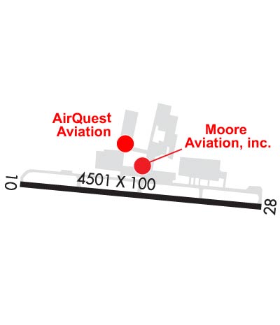
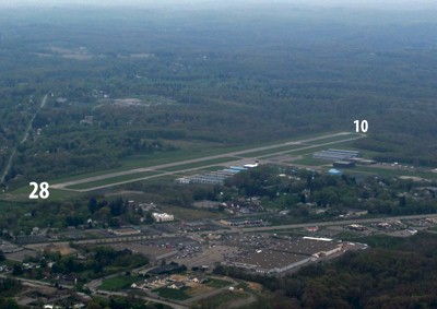
| Lat: N 4046.3 Long: W 08023.5 Elev: 1253 Var: +07 Longest Runway: 4501 | ||
| Clr Del: 124.85 TW CLD Dept. ATIS: 118.35 Arr. ATIS: 118.35 AWOS: 118.35 Ground: 121.8 Tower: 120.3 | ||
| |||||||||||||||||||||||||||||||
| |||||||||||||||||||||||||||||||
| |||||||||||||||||||||||||||||||
| |||||||||||||||||||||||||||||||
| Rwy | Rwy | |||||||
| 4501x100 | 4501' | 109.30 - 101° | 4501x100 | 4501' | ||||
| Runway ID | Single Wheel | Double Wheel | Double Tandem Wheel | Dual Double Wheel |
| 10/28 | 16,000 | 32,000 | N/A | N/A |
| These numbers are Advisory and are not limits. The Airport Manager should have more accurate Weight Limits | ||||
 Airport Diagram might not be current. | |
| Facility Name: | BEAVER COUNTY |
| City Name: | BEAVER FALLS |
| County: | BEAVER |
| State abbrev: | PA |
| State Name: | PENNSYLVANIA |
| Ownership: | PUBLICLY OWNED |
| Use: | OPEN TO THE PUBLIC |
| Owner's Name: | BEAVER COUNTY AIRPORT AUTHORITY |
| Address: | COURT HOUSE |
| BEAVER, PA 15009 | |
| Owner's Phone: | 724-728-3934 |
| Manager's Name: | TIMOTHY NESTOR |
| Address: | 15 PIPER ST |
| BEAVER FALLS, PA 15010 | |
| Phone: | 724-847-4662 |
| FAA Region: | EASTERN |
| FAA Field Office: | HAR |
| Date | Sunrise | Sunset |
|---|---|---|
| 02/05/25 Wednesday | 7:28 | 17:44 |
| 02/06/25 Thursday | 7:27 | 17:45 |
| 02/07/25 Friday | 7:26 | 17:46 |
| 02/08/25 Saturday | 7:25 | 17:48 |
| 02/09/25 Sunday | 7:23 | 17:49 |
| 02/10/25 Monday | 7:22 | 17:50 |
| 02/11/25 Tuesday | 7:21 | 17:51 |
| 02/12/25 Wednesday | 7:20 | 17:53 |
| 02/13/25 Thursday | 7:19 | 17:54 |
| 02/14/25 Friday | 7:17 | 17:55 |
| 02/15/25 Saturday | 7:16 | 17:56 |
| 02/16/25 Sunday | 7:15 | 17:57 |
| 02/17/25 Monday | 7:13 | 17:59 |
| 02/18/25 Tuesday | 7:12 | 18:00 |
| Airport Attendance Schedule | MON-FRI 0700-2100, UNATNDD FED HOL ALL, SAT-SUN 0900-1600 |
| Airport Status | OPERATIONAL (This Status can change at any time - please check NOTAMS) |
| Airport Lighting Schedule | ATCT-CTL. WHEN ATCT CLSD MIRL RY 10/28 & TWY LGTS OPER LOW INTST. INCREASE INTST & ACTVT REIL RYS 10 & 28 - CTAF. PAPI RYS 10 & 28 OPER CONT. |
| Airport Storage Available | Tie Downs, Hanger |
| Extra Services Available | Air Freight, Air Ambulance, Avionics, Charter, Flight Instruction, Aircraft Rental, Annual Surveying |
| Wind Indicator | YES - (lighted) |
| Control Tower | YES |
| CTAF Frequency | 120.300 |
| Unicom Frequency | |
| Rotating Beacon Color | WG |
| Segmented Circle | NO |
| Landing Fee | NO |
| Airport Inspected | STATE - performed by STATE AERONAUTICAL PERSONNEL |
| Inspection Date | 08/27/2024 |
| Type of Fuel Available | Grade 100LL, JET A (freeze point -40C), JET A |
| Airframe Repair Service | MAJOR |
| Power Plant Repair Service | MAJOR |
| Latitude | N4046.3 |
| Longitude | W08023.5 (ESTIMATED) |
| Arpt Elevation | 1252ft (SURVEYED) |
| Magnetic Variation | 07W |
| 3 miles NW | of BEAVER FALLS |
| Traffic Pattern Altitude | |
| Sectional Chart | DETROIT |
| Operations (Reported) | Yearly | Avg. Daily |
|---|---|---|
| General Aviation Transient | 0 | 0 |
| General Aviation Local | 0 | 0 |
| Air Taxi | 0 | 0 |
| Commerical | 0 | 0 |
| Commuter | 0 | 0 |
| Military | 0 | 0 |
| Aircraft based on Field | |
|---|---|
| General Aviation Singles | 0 |
| General Aviation Multi | 0 |
| Jet Aircraft | 0 |
| General Aviation Helicopters | 0 |
| Military Aircraft | 0 |
| Gliders | 0 |
| Ultralights | 0 |
| FSS on field | NO |
| FSS tie-in | ALTOONA |
| FSS Phone | 1-800-WX-BRIEF |
| Who issues Notams | BVI |
| Notam D service at airport | YES |
| ARTCC Name | CLEVELAND |
| Airport Certification | |
| Aircraft Rescue & Firefighting Index | None |
| Airport of Entry | No |
| Custom Landing Rights | No |
| Joint Civil/Military | No |
| Military Landing rights | YES |
| NATIONAL PLAN OF INTEGRATED AIRPORT SYSTEMS (NPIAS) |
| GRANT AGREEMENTS UNDER FAAP/ADAP/AIP |
| ASSURANCES PURSUANT TO TITLE VI, CIVIL RIGHTS ACT OF 1964 |
| (E94) SAWRS. |
| NOISE ABATEMENT PROCS IN EFCT FOR DEPS ONLY, CTC AMGR 0800-1600 FOR DTLS AT 724-847-4662. |
Airport Communications & Frequencies:
| |||||||||||||||||||||||
| Runway: 10 | Runway: 28 | ||
| Mag heading: | 101° | Mag heading: | 281° |
| Rwy Slope: | 1.08% Up | Rwy Slope: | -1.08% Down |
| Approach: | LOCALIZER | Approach: | |
| Pattern: | Left Traffic | Pattern: | Left Traffic |
| Markings: | NONPRECISION INSTRUMENT | Markings: | NONPRECISION INSTRUMENT |
| Marking Condition: | FAIR | Marking Condition: | FAIR |
| Arresting Dev: | Arresting Dev: | ||
| Lat & Long: | N4046.4 W08024.0 | Lat. & Long.: | N4046.3 W08023.0 |
| Elev: | 1204.2 ft. MSL | Elev: | 1252.7 ft. MSL |
| TCH: | 42 ft. AGL | TCH: | 43 ft. AGL |
| Visual Glide Path: | 3.00 degrees | Visual Glide Path: | 3.00 degrees |
| Displaced Threshold: | No | Displaced Threshold: | No |
| Touchdown Zone: | YES | Touchdown Zone: | YES |
| Touchdown Elev.: | 1237.6 feet | Touchdown Elev.: | 1252.7 feet |
| Visual Glide Slope: | 4-Light PAPI on LEFT side of Runway; VGSI AND GLIDEPATH NOT COINCIDENT. | Visual Glide Slope: | 4-Light PAPI on LEFT side of Runway; VGSI AND GLIDEPATH NOT COINCIDENT. |
| RVR Equipment: | RVR Equipment: | ||
| RVV Equipment: | NO | RVV Equipment: | NO |
| Approach Lights: | Approach Lights: | ||
| REIL: | YES | REIL: | YES; RY 28 REILS OTS INDEFINITELY. |
| Centerline Lights: | NO | Centerline Lights: | NO |
| Touchdown lights: | NO | Touchdown lights: | NO |
| Runway Category: | Runway with a Non-precision Approach having visibility minimums greater than 3/4 mile | Runway Category: | Runway with a Non-precision Approach having visibility minimums greater than 3/4 mile |
| Declared Distances: | Declared Distances: | ||
| Obstructions: | TREES | Obstructions: | TREES |
| Marked: | NOT Marked/Lighted | Marked: | NOT Marked/Lighted |
| Clearance slope: | 19:1 | Clearance slope: | 28:1 |
| Obstruction height: | 78 feet AGL | Obstruction height: | 19 feet AGL |
| Dist. from runway: | 1759 feet | Dist. from runway: | 734 feet |
| Centerline offset: | 286 right of centerline | Centerline offset: | 12 feet left of centerline |
| Comments: | Comments: | RWY 28: 20 FT TREES, 13 FT FM RWY END, 195 FT LEFT. |
Thanks for using FltPlan.com
all rights reserved © 1999-2025 by Flight Plan LLC