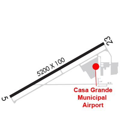
| CASA GRANDE MUNI CASA GRANDE AZ |
| |
| Lat: N 3257.3 Long: W 11146.0 Elev: 1464 Var: -12 Longest Runway: 5200 | ||
| AWOS: 132.17 CTAF: 122.7 | ||
| |||||||||||||||||||||||
| |||||||||||||||||||||||
| |||||||||||||||||||||||
| Rwy | Rwy | |||||||
| 5200x100 | 5200' | 111.15 - 047° | 5200x100 | 5200' | ||||
| Runway ID | Single Wheel | Double Wheel | Double Tandem Wheel | Dual Double Wheel |
| 05/23 | 18,500 | 65,000 | N/A | N/A |
| These numbers are Advisory and are not limits. The Airport Manager should have more accurate Weight Limits | ||||
 Airport Diagram might not be current. | |
| Facility Name: | CASA GRANDE MUNI |
| City Name: | CASA GRANDE |
| County: | PINAL |
| State abbrev: | AZ |
| State Name: | ARIZONA |
| Ownership: | PUBLICLY OWNED |
| Use: | OPEN TO THE PUBLIC |
| Owner's Name: | CITY OF CASA GRANDE |
| Address: | CITY HALL 510 E. FLORENCE BLVD |
| CASA GRANDE, AZ 85222 | |
| Owner's Phone: | 520-421-8625 |
| Manager's Name: | DAVID REFFNER |
| Address: | 3225 N. LEAR AVE. |
| CASA GRANDE, AZ 85122 | |
| Phone: | (520) 421-8625; EX: 3347. |
| FAA Region: | WESTERN-PACIFIC |
| FAA Field Office: | PHX |
| Date | Sunrise | Sunset |
|---|---|---|
| 09/11/25 Thursday | 6:08 | 18:39 |
| 09/12/25 Friday | 6:09 | 18:38 |
| 09/13/25 Saturday | 6:09 | 18:36 |
| 09/14/25 Sunday | 6:10 | 18:35 |
| 09/15/25 Monday | 6:11 | 18:33 |
| 09/16/25 Tuesday | 6:11 | 18:32 |
| 09/17/25 Wednesday | 6:12 | 18:31 |
| 09/18/25 Thursday | 6:12 | 18:29 |
| 09/19/25 Friday | 6:13 | 18:28 |
| 09/20/25 Saturday | 6:14 | 18:27 |
| 09/21/25 Sunday | 6:14 | 18:25 |
| 09/22/25 Monday | 6:15 | 18:24 |
| 09/23/25 Tuesday | 6:16 | 18:23 |
| 09/24/25 Wednesday | 6:16 | 18:21 |
| Airport Attendance Schedule | 7 Days A Week 0600-1600 |
| Airport Status | OPERATIONAL (This Status can change at any time - please check NOTAMS) |
| Airport Lighting Schedule | ACTVT MALSR RWY 05 - CTAF. |
| Airport Storage Available | Tie Downs |
| Extra Services Available | Avionics |
| Wind Indicator | YES - (lighted) |
| Control Tower | NO |
| CTAF Frequency | 122.700 |
| Unicom Frequency | 122.700 |
| Rotating Beacon Color | WG |
| Segmented Circle | YES |
| Landing Fee | NO |
| Airport Inspected | STATE - performed by PRIVATE CONTRACT PERSONNEL |
| Inspection Date | 04/17/2023 |
| Type of Fuel Available | Grade 100LL, JET A; -10AVBL H24 WITH CREDIT CARD.; -A+AFT HR; CALL OUT FEE - 520-251-3366. |
| Airframe Repair Service | MAJOR |
| Power Plant Repair Service | MAJOR |
| Latitude | N3257.3 |
| Longitude | W11146.0 (ESTIMATED) |
| Arpt Elevation | 1464ft (SURVEYED) |
| Magnetic Variation | 12E |
| 5 miles N | of CASA GRANDE |
| Traffic Pattern Altitude | 1038 |
| Sectional Chart | PHOENIX |
| Operations (Reported) | Yearly | Avg. Daily |
|---|---|---|
| General Aviation Transient | 0 | 0 |
| General Aviation Local | 0 | 0 |
| Air Taxi | 0 | 0 |
| Commerical | 0 | 0 |
| Commuter | 0 | 0 |
| Military | 0 | 0 |
| Aircraft based on Field | |
|---|---|
| General Aviation Singles | 0 |
| General Aviation Multi | 0 |
| Jet Aircraft | 0 |
| General Aviation Helicopters | 0 |
| Military Aircraft | 0 |
| Gliders | 0 |
| Ultralights | 0 |
| FSS on field | NO |
| FSS tie-in | PRESCOTT |
| FSS Phone | 1-800-WX-BRIEF |
| Who issues Notams | CGZ |
| Notam D service at airport | YES |
| ARTCC Name | ALBUQUERQUE |
| Airport Certification | |
| Aircraft Rescue & Firefighting Index | None |
| Airport of Entry | No |
| Custom Landing Rights | No |
| Joint Civil/Military | No |
| Military Landing rights | YES |
| NATIONAL PLAN OF INTEGRATED AIRPORT SYSTEMS (NPIAS) |
| GRANT AGREEMENTS UNDER FAAP/ADAP/AIP |
| SURPLUS PROPERTY AGREEMENT UNDER PUBLIC LAW 289 |
| ASSURANCES PURSUANT TO TITLE VI, CIVIL RIGHTS ACT OF 1964 |
| TSNT PRAC APCH INVOF ARPT. |
| TWY HOLD LINES CNCTG TO RWY 280 FT FM CNTRLN. |
| TAXI ON TWY B; BE ALERT TO ACFT HLDG ON CNCTG TWYS. |
| FOR CD CTC ALBUQUERQUE ARTCC AT 505-856-4861. |
| PAJA IN PDZ SE CORNER OF ARPT. |
| RWY 23 GPS APCH OPS NECESSITY ONLY. |
Airport Communications & Frequencies:
| |||||||||
| Runway: 05 | Runway: 23 | ||
| Mag heading: | 48° | Mag heading: | 228° |
| Rwy Slope: | .33% Up | Rwy Slope: | -.33% Down |
| Approach: | ILS | Approach: | |
| Pattern: | Left Traffic | Pattern: | Right Traffic |
| Markings: | PRECISION INSTRUMENT | Markings: | NONPRECISION INSTRUMENT |
| Marking Condition: | FAIR | Marking Condition: | GOOD |
| Arresting Dev: | Arresting Dev: | ||
| Lat & Long: | N3257.1 W11146.4 | Lat. & Long.: | N3257.5 W11145.6 |
| Elev: | 1447.2 ft. MSL | Elev: | 1464.4 ft. MSL |
| TCH: | 43 ft. AGL | TCH: | 40 ft. AGL |
| Visual Glide Path: | 3.00 degrees | Visual Glide Path: | 3.00 degrees |
| Displaced Threshold: | No | Displaced Threshold: | No |
| Touchdown Zone: | YES | Touchdown Zone: | YES |
| Touchdown Elev.: | 1458.4 feet | Touchdown Elev.: | 1464.4 feet |
| Visual Glide Slope: | 2-Light PAPI on LEFT side of Runway | Visual Glide Slope: | 2-Light PAPI on LEFT side of Runway |
| RVR Equipment: | RVR Equipment: | ||
| RVV Equipment: | NO | RVV Equipment: | NO |
| Approach Lights: | MALSR - 1,400 foot medium intensity approach lighting system with runway alignment indicator lights | Approach Lights: | |
| REIL: | NO | REIL: | NO |
| Centerline Lights: | NO | Centerline Lights: | NO |
| Touchdown lights: | NO | Touchdown lights: | NO |
| Runway Category: | Precision Instrument Runway | Runway Category: | Runway with a Non-precision Approach having visibility minimums greater than 3/4 mile |
| Declared Distances: | Declared Distances: | ||
| Obstructions: | ROAD | Obstructions: | ROAD |
| Marked: | NOT Marked/Lighted | Marked: | NOT Marked/Lighted |
| Clearance slope: | Clearance slope: | ||
| Obstruction height: | 10 feet AGL | Obstruction height: | 10 feet AGL |
| Dist. from runway: | 200 feet | Dist. from runway: | 200 feet |
| Centerline offset: | 215 left of centerline | Centerline offset: | 125 feet right of centerline |
| Comments: | 10 FT ROAD AT RWY END 130 FT L; 6 FT FENCE & 3 FT TREES & BRUSH 200 FT FM RWY END 100-300 L OF CNTRLN. | Comments: | 10 FT ROAD 0-200 FT FM THR 125 FT R OF CNTRLN; 3-5 FT BRUSH 240-500 FT R OF CNTRLN N SIDE PRIM SFC. |
Thanks for using FltPlan.com
all rights reserved © 1999-2025 by Flight Plan LLC