| BISBEE DOUGLAS INTL DOUGLAS BISBEE AZ |
| |
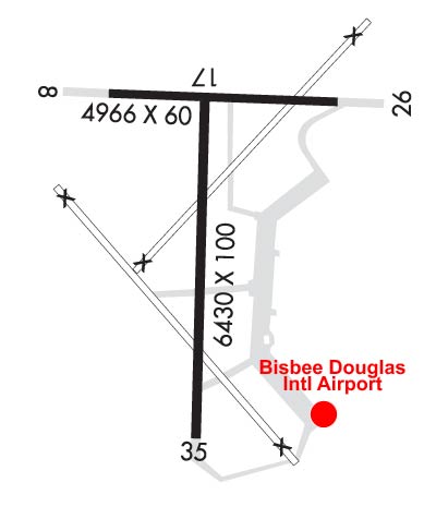
| Lat: N 3128.1 Long: W 10936.2 Elev: 4150 Var: -12 Longest Runway: 6430 | ||
| AWOS: 119.27 CTAF: 123.0 | ||
| ||||||||||||||||||||||||||||||||||||||||||||||||||||||||||||||
| ||||||||||||||||||||||||||||||||||||||||||||||||||||||||||||||
| ||||||||||||||||||||||||||||||||||||||||||||||||||||||||||||||
| Rwy | Rwy | |||||||
| 4966x60 | 4966' | 4966x60 | 4966' | |||||
| 6430x100 | 6430' | 6430x100 | 6430' | |||||
| Runway ID | Single Wheel | Double Wheel | Double Tandem Wheel | Dual Double Wheel |
| 08/26 | 12,500 | N/A | N/A | N/A |
| 17/35 | 30,000 | 160,000 | 250,000 | N/A |
| These numbers are Advisory and are not limits. The Airport Manager should have more accurate Weight Limits | ||||
 Airport Diagram might not be current. | |
| Facility Name: | BISBEE DOUGLAS INTL |
| City Name: | DOUGLAS BISBEE |
| County: | COCHISE |
| State abbrev: | AZ |
| State Name: | ARIZONA |
| Ownership: | PUBLICLY OWNED |
| Use: | OPEN TO THE PUBLIC |
| Owner's Name: | COCHISE COUNTY |
| Address: | 1415 WEST MELODY LANE BLDG F |
| BISBEE, AZ 85603 | |
| Owner's Phone: | (520) 432-9268 |
| Manager's Name: | DANIEL COXWORTH |
| Address: | 1415 W. MELODY LANE , BUILDING E |
| BISBEE, AZ 85603 | |
| Phone: | (520) 432-9268; EMERGENCY NUMBER 520-432-9268. |
| FAA Region: | WESTERN-PACIFIC |
| FAA Field Office: | PHX |
| Date | Sunrise | Sunset |
|---|---|---|
| 09/24/21 Friday | 6:08 | 18:13 |
| 09/25/21 Saturday | 6:08 | 18:11 |
| 09/26/21 Sunday | 6:09 | 18:10 |
| 09/27/21 Monday | 6:10 | 18:09 |
| 09/28/21 Tuesday | 6:10 | 18:07 |
| 09/29/21 Wednesday | 6:11 | 18:06 |
| 09/30/21 Thursday | 6:11 | 18:05 |
| 10/01/21 Friday | 6:12 | 18:04 |
| 10/02/21 Saturday | 6:13 | 18:02 |
| 10/03/21 Sunday | 6:13 | 18:01 |
| 10/04/21 Monday | 6:14 | 18:00 |
| 10/05/21 Tuesday | 6:15 | 17:59 |
| 10/06/21 Wednesday | 6:15 | 17:57 |
| 10/07/21 Thursday | 6:16 | 17:56 |
| Airport Attendance Schedule | MON-FRI 0800-1700 |
| Airport Status | OPERATIONAL (This Status can change at any time - please check NOTAMS) |
| Airport Lighting Schedule | ACTVT MIRL RY 17/35 & VASI RY 17 - CTAF. |
| Airport Storage Available | Tie Downs |
| Extra Services Available | NONE |
| Wind Indicator | YES - (lighted) |
| Control Tower | NO |
| CTAF Frequency | 123.000 |
| Unicom Frequency | 123.000 |
| Rotating Beacon Color | CLEAR-GREEN (Light Land Airport) |
| Segmented Circle | YES |
| Landing Fee | NO |
| Airport Inspected | STATE - performed by PRIVATE CONTRACT PERSONNEL |
| Inspection Date | 03/27/2020 |
| Type of Fuel Available | Grade 100LL, JET A-1 (icing inhibitor, freeze point -50C); -10SELF-SERVE FUEL, PHONE 520-508-3629. |
| Airframe Repair Service | MINOR |
| Power Plant Repair Service | MINOR |
| Latitude | N3128.1 |
| Longitude | W10936.2 (ESTIMATED) |
| Arpt Elevation | 4150ft (SURVEYED) |
| Magnetic Variation | 12E |
| 8 miles NW | of DOUGLAS BISBEE |
| Traffic Pattern Altitude | |
| Sectional Chart | PHOENIX |
| Operations (Reported) | Yearly | Avg. Daily |
|---|---|---|
| General Aviation Transient | 15000 | 41 |
| General Aviation Local | 4000 | 11 |
| Air Taxi | 500 | 1 |
| Commerical | 0 | 0 |
| Commuter | 0 | 0 |
| Military | 10000 | 27 |
| Aircraft based on Field | |
|---|---|
| General Aviation Singles | 2 |
| General Aviation Multi | 0 |
| Jet Aircraft | 0 |
| General Aviation Helicopters | 0 |
| Military Aircraft | 0 |
| Gliders | 0 |
| Ultralights | 0 |
| FSS on field | NO |
| FSS tie-in | PRESCOTT |
| FSS Phone | 1-800-WX-BRIEF |
| Who issues Notams | DUG |
| Notam D service at airport | YES |
| ARTCC Name | ALBUQUERQUE |
| Airport Certification | |
| Aircraft Rescue & Firefighting Index | None |
| Airport of Entry | YES |
| Custom Landing Rights | YES |
| Joint Civil/Military | No |
| Military Landing rights | YES |
| NATIONAL PLAN OF INTEGRATED AIRPORT SYSTEMS (NPIAS) |
| GRANT AGREEMENTS UNDER FAAP/ADAP/AIP |
| SURPLUS PROPERTY AGREEMENT UNDER PUBLIC LAW 289 |
| ASSURANCES PURSUANT TO TITLE VI, CIVIL RIGHTS ACT OF 1964 |
| AGREEMENT UNDER DLAND OR DCLA HAS EXPIRED. |
| THE TWY TO RY 35 IS IN POOR CONDITION WITH RUTS & LOOSE AGGREGATE. |
| WILDLIFE ON OR INVOF ARPT. |
| FOR CD IF UNA TO CTC ON FSS FREQ, CTC ALBUQUERQUE ARTCC AT 505-856-4561. |
| RWY 08/2 6 RY 08/26 VFR OPNS ONLY; DAYLIGHT USE ONLY. |
| RWY 17/3 5 RFSC 100 FT WIDE. |
Airport Communications & Frequencies:
| |||||||||
| Runway: 08 | Runway: 26 | ||
| Mag heading: | 78° | Mag heading: | 258° |
| Rwy Slope: | .69% Up | Rwy Slope: | -.69% Down |
| Approach: | Approach: | ||
| Pattern: | Left Traffic | Pattern: | Left Traffic |
| Markings: | BASIC | Markings: | BASIC |
| Marking Condition: | GOOD | Marking Condition: | GOOD |
| Arresting Dev: | Arresting Dev: | ||
| Lat & Long: | N3128.4 W10936.6 | Lat. & Long.: | N3128.4 W10935.7 |
| Elev: | 4115.6 ft. MSL | Elev: | 4150.0 ft. MSL |
| TCH: | TCH: | ||
| Visual Glide Path: | Visual Glide Path: | ||
| Displaced Threshold: | No | Displaced Threshold: | No |
| Touchdown Zone: | YES | Touchdown Zone: | YES |
| Touchdown Elev.: | 4133.5 feet | Touchdown Elev.: | 4150.2 feet |
| Visual Glide Slope: | Visual Glide Slope: | ||
| RVR Equipment: | RVR Equipment: | ||
| RVV Equipment: | NO | RVV Equipment: | NO |
| Approach Lights: | Approach Lights: | ||
| REIL: | NO | REIL: | NO |
| Centerline Lights: | NO | Centerline Lights: | NO |
| Touchdown lights: | NO | Touchdown lights: | NO |
| Runway Category: | Runway with a Visual Approach | Runway Category: | Runway with a Visual Approach |
| Declared Distances: | Declared Distances: | ||
| Obstructions: | BRUSH | Obstructions: | BRUSH |
| Marked: | NOT Marked/Lighted | Marked: | NOT Marked/Lighted |
| Clearance slope: | 16:1 | Clearance slope: | 12:1 |
| Obstruction height: | 4 feet AGL | Obstruction height: | 4 feet AGL |
| Dist. from runway: | 264 feet | Dist. from runway: | 250 feet |
| Centerline offset: | 44 right of centerline | Centerline offset: | 40 feet left of centerline |
| Comments: | RWY 8, 1-8 FT WEEDS 0-200 FT FM THLD, 125 FT LEFT & RIGHT. | Comments: | RWY 26, 4-6 FT BRUSH 20-200 FT FM THLD, 125 FT BOTH SIDES OF CNTRLN. |
| Runway: 17 | Runway: 35 | ||
| Mag heading: | 168° | Mag heading: | 348° |
| Rwy Slope: | -.55% Down | Rwy Slope: | .55% Up |
| Approach: | Approach: | ||
| Pattern: | Left Traffic | Pattern: | Left Traffic |
| Markings: | NONPRECISION INSTRUMENT | Markings: | NONPRECISION INSTRUMENT |
| Marking Condition: | GOOD | Marking Condition: | GOOD |
| Arresting Dev: | Arresting Dev: | ||
| Lat & Long: | N3128.4 W10936.3 | Lat. & Long.: | N3127.4 W10936.3 |
| Elev: | 4124.5 ft. MSL | Elev: | 4088.9 ft. MSL |
| TCH: | 53 ft. AGL | TCH: | |
| Visual Glide Path: | 3.25 degrees | Visual Glide Path: | |
| Displaced Threshold: | No | Displaced Threshold: | No |
| Touchdown Zone: | YES | Touchdown Zone: | YES |
| Touchdown Elev.: | 4125.0 feet | Touchdown Elev.: | 4107.6 feet |
| Visual Glide Slope: | 2-Box VASI on LEFT side of Runway | Visual Glide Slope: | |
| RVR Equipment: | RVR Equipment: | ||
| RVV Equipment: | NO | RVV Equipment: | NO |
| Approach Lights: | Approach Lights: | ||
| REIL: | NO | REIL: | NO |
| Centerline Lights: | NO | Centerline Lights: | NO |
| Touchdown lights: | NO | Touchdown lights: | NO |
| Runway Category: | Runway with a Non-precision Approach having visibility minimums greater than 3/4 mile | Runway Category: | Runway with a Visual Approach |
| Declared Distances: | Declared Distances: | ||
| Obstructions: | Obstructions: | BRUSH | |
| Marked: | Marked: | NOT Marked/Lighted | |
| Clearance slope: | 50:1 | Clearance slope: | 1:1 |
| Obstruction height: | Obstruction height: | 4 feet AGL | |
| Dist. from runway: | Dist. from runway: | 205 feet | |
| Centerline offset: | Centerline offset: | 72 feet left of centerline | |
| Comments: | AIRPLANE TAIL HEIGHT OF 20 FT ON RWY 08/26 AT 55 FT TO CNTRLN APCH SLOPE 04:1 AT THLD. +3-4 FT BRUSH & WEEDS 125 FT FM THLD, 125-150 FT RIGHT OF CNTRLN. | Comments: | RWY 35 1-2 FT WEEDS 50-200 FT FM THLD, 75-250 FT BOTH SIDES OF CNTRLN. |
Thanks for using FltPlan.com
all rights reserved © 1999-2021 by Flight Plan LLC