| ELKHART MUNI ELKHART IN |
| |
| Lat: N 4143.2 Long: W 08600.2 Elev: 778 Var: +04 Longest Runway: 6500 | ||
| Clr Del: 119.7 TW CLSD AWOS: 124.47 Ground: 121.8 Tower: 119.5 | ||
| ||||||||||||||||||||||||||||||||||||||||||||||||||||||||||||||||||||
| ||||||||||||||||||||||||||||||||||||||||||||||||||||||||||||||||||||
| ||||||||||||||||||||||||||||||||||||||||||||||||||||||||||||||||||||
| Rwy | Rwy | |||||||
| 2480x250 | 2480' | 2480x250 | 2480' | |||||
| 6500x120 | 6500' | 6500x120 | 6500' | 111.50 - 273° | ||||
| 3999x75 | 3999' | 3999x75 | 3999' | |||||
| Runway ID | Single Wheel | Double Wheel | Double Tandem Wheel | Dual Double Wheel |
| 08/26 | N/A | N/A | N/A | N/A |
| 09/27 | 40,000 | 60,000 | 120,000 | N/A |
| 18/36 | 45,000 | 65,000 | N/A | N/A |
| These numbers are Advisory and are not limits. The Airport Manager should have more accurate Weight Limits | ||||
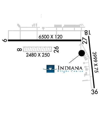 Airport Diagram might not be current. | |
| Facility Name: | ELKHART MUNI |
| City Name: | ELKHART |
| County: | ELKHART |
| State abbrev: | IN |
| State Name: | INDIANA |
| Ownership: | PUBLICLY OWNED |
| Use: | OPEN TO THE PUBLIC |
| Owner's Name: | CITY OF ELKHART |
| Address: | 1211 CO RD 6 W |
| ELKHART, IN 46514 | |
| Owner's Phone: | 574-264-5217 |
| Manager's Name: | ANDY JONES |
| Address: | 1211 CO RD 6 W |
| ELKHART, IN 46514 | |
| Phone: | 574-264-5217 |
| FAA Region: | GREAT LAKES |
| FAA Field Office: | CHI |
| Date | Sunrise | Sunset |
|---|---|---|
| 09/24/21 Friday | 7:33 | 19:38 |
| 09/25/21 Saturday | 7:34 | 19:36 |
| 09/26/21 Sunday | 7:35 | 19:35 |
| 09/27/21 Monday | 7:36 | 19:33 |
| 09/28/21 Tuesday | 7:37 | 19:31 |
| 09/29/21 Wednesday | 7:38 | 19:30 |
| 09/30/21 Thursday | 7:40 | 19:28 |
| 10/01/21 Friday | 7:41 | 19:26 |
| 10/02/21 Saturday | 7:42 | 19:24 |
| 10/03/21 Sunday | 7:43 | 19:23 |
| 10/04/21 Monday | 7:44 | 19:21 |
| 10/05/21 Tuesday | 7:45 | 19:19 |
| 10/06/21 Wednesday | 7:46 | 19:18 |
| 10/07/21 Thursday | 7:47 | 19:16 |
| Airport Attendance Schedule | 7 Days A Week 0600-2200 |
| Airport Status | OPERATIONAL (This Status can change at any time - please check NOTAMS) |
| Airport Lighting Schedule | WHEN ATCT CLSD MIRL RY 18/36 & HIRL RY 09/27 PRESET LOW INTST; TO INCR INTST & ACTVT VASI RY 09 & RY 36; PAPI RY 18 & 27; REIL RYS 18 & 36 & 09 & MALSR RY 27 - CTAF. |
| Airport Storage Available | Tie Downs, Hanger |
| Extra Services Available | Charter, Aircraft Rental, Aircraft Sales |
| Wind Indicator | YES - (lighted) |
| Control Tower | YES |
| CTAF Frequency | 119.500 |
| Unicom Frequency | 122.950 |
| Rotating Beacon Color | CLEAR-GREEN (Light Land Airport) |
| Segmented Circle | YES |
| Landing Fee | NO |
| Airport Inspected | FEDERAL - performed by STATE AERONAUTICAL PERSONNEL |
| Inspection Date | 10/18/2018 |
| Type of Fuel Available | Grade 100LL, JET A (freeze point -40C) |
| Airframe Repair Service | MAJOR |
| Power Plant Repair Service | MINOR |
| Latitude | N4143.2 |
| Longitude | W08600.2 (ESTIMATED) |
| Arpt Elevation | 777ft (SURVEYED) |
| Magnetic Variation | 04W |
| 3 miles NW | of ELKHART |
| Traffic Pattern Altitude | |
| Sectional Chart | CHICAGO |
| Operations (Reported) | Yearly | Avg. Daily |
|---|---|---|
| General Aviation Transient | 17354 | 48 |
| General Aviation Local | 13502 | 37 |
| Air Taxi | 932 | 3 |
| Commerical | 0 | 0 |
| Commuter | 0 | 0 |
| Military | 354 | 1 |
| Aircraft based on Field | |
|---|---|
| General Aviation Singles | 22 |
| General Aviation Multi | 5 |
| Jet Aircraft | 8 |
| General Aviation Helicopters | 1 |
| Military Aircraft | 2 |
| Gliders | 1 |
| Ultralights | 0 |
| FSS on field | NO |
| FSS tie-in | TERRE HAUTE |
| FSS Phone | 1-800-WX-BRIEF |
| Who issues Notams | EKM |
| Notam D service at airport | YES |
| ARTCC Name | CHICAGO |
| Airport Certification | |
| Aircraft Rescue & Firefighting Index | None |
| Airport of Entry | No |
| Custom Landing Rights | No |
| Joint Civil/Military | No |
| Military Landing rights | YES |
| NATIONAL PLAN OF INTEGRATED AIRPORT SYSTEMS (NPIAS) |
| GRANT AGREEMENTS UNDER FAAP/ADAP/AIP |
| ASSURANCES PURSUANT TO TITLE VI, CIVIL RIGHTS ACT OF 1964 |
| TWY A NOT AVBL TO ACFT WITH MORE THAN 30 PSGR SEATS. |
| (E81) TWY MKD WITH REFLECTORS. |
| (E94) SWARS. |
| RWY 08/2 6 RY 08/26 MARKED WITH WHITE CORNER MARKERS. VFR ONLY AND ONLY OPR DURING ATCT HRS. |
Airport Communications & Frequencies:
| |||||||||||||||||||||||||
| Runway: 08 | Runway: 26 | ||
| Mag heading: | 93° | Mag heading: | 273° |
| Rwy Slope: | .16% Up | Rwy Slope: | -.16% Down |
| Approach: | Approach: | ||
| Pattern: | Left Traffic | Pattern: | Left Traffic |
| Markings: | NONE | Markings: | NONE |
| Marking Condition: | FAIR | Marking Condition: | FAIR |
| Arresting Dev: | Arresting Dev: | ||
| Lat & Long: | N4143.2 W08600.9 | Lat. & Long.: | N4143.2 W08600.3 |
| Elev: | 769.3 ft. MSL | Elev: | 773.3 ft. MSL |
| TCH: | TCH: | ||
| Visual Glide Path: | Visual Glide Path: | ||
| Displaced Threshold: | No | Displaced Threshold: | No |
| Touchdown Zone: | YES | Touchdown Zone: | YES |
| Touchdown Elev.: | 773.3 feet | Touchdown Elev.: | 773.3 feet |
| Visual Glide Slope: | Visual Glide Slope: | ||
| RVR Equipment: | RVR Equipment: | ||
| RVV Equipment: | NO | RVV Equipment: | NO |
| Approach Lights: | Approach Lights: | ||
| REIL: | NO | REIL: | NO |
| Centerline Lights: | NO | Centerline Lights: | NO |
| Touchdown lights: | NO | Touchdown lights: | NO |
| Runway Category: | Runway with a Visual Approach | Runway Category: | Runway with a Visual Approach |
| Declared Distances: | TORA:2480' TODA:2480' ASDA:2480' LDA:2480' | Declared Distances: | TORA:2480' TODA:2480' ASDA:2480' LDA:2480' |
| Runway: 09 | Runway: 27 | ||
| Mag heading: | 94° | Mag heading: | 274° |
| Rwy Slope: | .10% Up | Rwy Slope: | -.10% Down |
| Approach: | Approach: | ILS | |
| Pattern: | Left Traffic | Pattern: | Left Traffic |
| Markings: | PRECISION INSTRUMENT | Markings: | PRECISION INSTRUMENT |
| Marking Condition: | GOOD | Marking Condition: | GOOD |
| Arresting Dev: | Arresting Dev: | ||
| Lat & Long: | N4143.3 W08601.2 | Lat. & Long.: | N4143.3 W08559.7 |
| Elev: | 770.4 ft. MSL | Elev: | 777.1 ft. MSL |
| TCH: | 38 ft. AGL | TCH: | 46 ft. AGL |
| Visual Glide Path: | 3.00 degrees | Visual Glide Path: | 3.00 degrees |
| Displaced Threshold: | No | Displaced Threshold: | No |
| Touchdown Zone: | YES | Touchdown Zone: | YES |
| Touchdown Elev.: | 776.8 feet | Touchdown Elev.: | 777.6 feet |
| Visual Glide Slope: | 4-BOX VASI ON LEFT SIDE OF RUNWAY | Visual Glide Slope: | 4-Light PAPI on LEFT side of Runway |
| RVR Equipment: | ROLLOUT | RVR Equipment: | TOUCHDOWN |
| RVV Equipment: | NO | RVV Equipment: | NO |
| Approach Lights: | Approach Lights: | MALSR - 1,400 foot medium intensity approach lighting system with runway alignment indicator lights | |
| REIL: | YES | REIL: | NO |
| Centerline Lights: | NO | Centerline Lights: | NO |
| Touchdown lights: | NO | Touchdown lights: | NO |
| Runway Category: | Runway with a Non-precision Approach having visibility minimums greater than 3/4 mile | Runway Category: | Precision Instrument Runway |
| Declared Distances: | TORA:6500' TODA:6500' ASDA:6500' LDA:6500' | Declared Distances: | TORA:6500' TODA:6500' ASDA:6500' LDA:6500' |
| Obstructions: | TREES | Obstructions: | TREES |
| Marked: | NOT Marked/Lighted | Marked: | NOT Marked/Lighted |
| Clearance slope: | 21:1 | Clearance slope: | 37:1 |
| Obstruction height: | 40 feet AGL | Obstruction height: | 65 feet AGL |
| Dist. from runway: | 1050 feet | Dist. from runway: | 2645 feet |
| Centerline offset: | Centerline offset: | ||
| Comments: | Comments: |
| Runway: 18 | Runway: 36 | ||
| Mag heading: | 176° | Mag heading: | 356° |
| Rwy Slope: | -.14% Down | Rwy Slope: | .14% Up |
| Approach: | Approach: | ||
| Pattern: | Left Traffic | Pattern: | Left Traffic |
| Markings: | NONPRECISION INSTRUMENT | Markings: | NONPRECISION INSTRUMENT |
| Marking Condition: | POOR; RWY CL & STRIPING FADED. | Marking Condition: | POOR; RWY CL & STRIPING FADED. |
| Arresting Dev: | Arresting Dev: | ||
| Lat & Long: | N4143.3 W08559.6 | Lat. & Long.: | N4142.7 W08559.5 |
| Elev: | 777.2 ft. MSL | Elev: | 771.8 ft. MSL |
| TCH: | 38 ft. AGL | TCH: | 57 ft. AGL |
| Visual Glide Path: | 3.00 degrees | Visual Glide Path: | 4.00 degrees |
| Displaced Threshold: | No | Displaced Threshold: | No |
| Touchdown Zone: | YES | Touchdown Zone: | YES |
| Touchdown Elev.: | 777.2 feet | Touchdown Elev.: | 776.1 feet |
| Visual Glide Slope: | 4-Light PAPI on LEFT side of Runway | Visual Glide Slope: | 4-BOX VASI ON LEFT SIDE OF RUNWAY; RY 36 VASI UNUSBL 7 DEG LEFT & RIGHT OF CNTRLN. |
| RVR Equipment: | RVR Equipment: | ||
| RVV Equipment: | NO | RVV Equipment: | NO |
| Approach Lights: | Approach Lights: | ||
| REIL: | YES | REIL: | YES |
| Centerline Lights: | NO | Centerline Lights: | NO |
| Touchdown lights: | NO | Touchdown lights: | NO |
| Runway Category: | Runway with a Non-precision Approach | Runway Category: | Runway with a Non-precision Approach |
| Declared Distances: | TORA:4001' TODA:4001' ASDA:4001' LDA:4001' | Declared Distances: | TORA:4001' TODA:4001' ASDA:4001' LDA:4001' |
| Obstructions: | TREES | Obstructions: | TREES |
| Marked: | NOT Marked/Lighted | Marked: | NOT Marked/Lighted |
| Clearance slope: | 19:1 | Clearance slope: | 19:1 |
| Obstruction height: | 50 feet AGL | Obstruction height: | 51 feet AGL |
| Dist. from runway: | 1170 feet | Dist. from runway: | 1170 feet |
| Centerline offset: | Centerline offset: | 250B | |
| Comments: | Comments: |
Thanks for using FltPlan.com
all rights reserved © 1999-2021 by Flight Plan LLC