| ENNIS - BIG SKY ENNIS MT |
| |
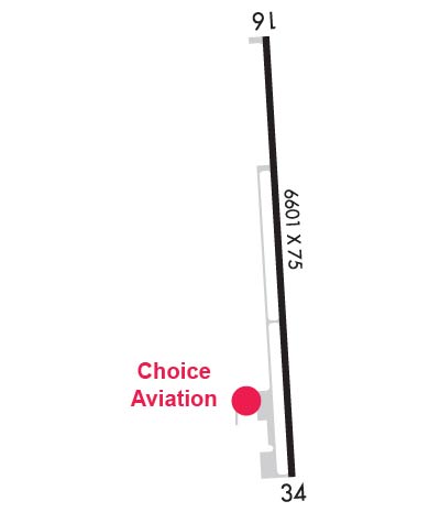
| Lat: N 4516.5 Long: W 11138.9 Elev: 5433 Var: -12 Longest Runway: 7600 | ||
| AWOS: 119.85 CTAF: 122.8 | ||
| |||||||||||||||||||||||
| |||||||||||||||||||||||
| |||||||||||||||||||||||
| Rwy | Rwy | |||||||
| 7600x100 | 7600' | 7600x100 | 7600' | |||||
| Runway ID | Single Wheel | Double Wheel | Double Tandem Wheel | Dual Double Wheel |
| 16/34 | 87,000 | 138,000 | 236,000 | N/A |
| These numbers are Advisory and are not limits. The Airport Manager should have more accurate Weight Limits | ||||
 Airport Diagram might not be current. | |
| Facility Name: | ENNIS BIG SKY |
| City Name: | ENNIS |
| County: | MADISON |
| State abbrev: | MT |
| State Name: | MONTANA |
| Ownership: | PUBLICLY OWNED |
| Use: | OPEN TO THE PUBLIC |
| Owner's Name: | MADISON COUNTY |
| Address: | MADISON COUNTY COURTHOUSE, PO BOX 278 |
| VIRGINIA CITY, MT 59755-0278 | |
| Owner's Phone: | 406-843-4277 |
| Manager's Name: | TROY HUNTER |
| Address: | 35 AIRPORT ROAD |
| ENNIS, MT 59729 | |
| Phone: | 406-682-7502 |
| FAA Region: | NORTHWEST MOUNTAIN |
| FAA Field Office: | HLN |
| Date | Sunrise | Sunset |
|---|---|---|
| 09/24/21 Friday | 7:16 | 19:21 |
| 09/25/21 Saturday | 7:17 | 19:19 |
| 09/26/21 Sunday | 7:18 | 19:17 |
| 09/27/21 Monday | 7:20 | 19:15 |
| 09/28/21 Tuesday | 7:21 | 19:13 |
| 09/29/21 Wednesday | 7:22 | 19:11 |
| 09/30/21 Thursday | 7:23 | 19:09 |
| 10/01/21 Friday | 7:24 | 19:07 |
| 10/02/21 Saturday | 7:26 | 19:05 |
| 10/03/21 Sunday | 7:27 | 19:03 |
| 10/04/21 Monday | 7:28 | 19:02 |
| 10/05/21 Tuesday | 7:30 | 19:00 |
| 10/06/21 Wednesday | 7:31 | 18:58 |
| 10/07/21 Thursday | 7:32 | 18:56 |
| Airport Attendance Schedule | 7 Days A Week 0700-1700 |
| Airport Status | OPERATIONAL (This Status can change at any time - please check NOTAMS) |
| Airport Lighting Schedule | ACTVT MIRL RWY 16/34 - CTAF. PAPI RWY 16 & 34 OPR CONSLY. |
| Airport Storage Available | Tie Downs, Hanger |
| Extra Services Available | Air Ambulance, Charter, Flight Instruction, Aircraft Rental |
| Wind Indicator | YES - (lighted) |
| Control Tower | NO |
| CTAF Frequency | 122.800 |
| Unicom Frequency | 122.800 |
| Rotating Beacon Color | CLEAR-GREEN (Light Land Airport) |
| Segmented Circle | YES |
| Landing Fee | NO |
| Airport Inspected | STATE - performed by STATE AERONAUTICAL PERSONNEL |
| Inspection Date | 03/12/2021 |
| Type of Fuel Available | Grade 100LL, JET A-1 (freeze point -50C), JET A-1 (icing inhibitor, freeze point -50C) |
| Airframe Repair Service | MINOR |
| Power Plant Repair Service | MINOR |
| Latitude | N4516.5 |
| Longitude | W11138.9 (ESTIMATED) |
| Arpt Elevation | 5432ft (SURVEYED) |
| Magnetic Variation | 12E |
| 6 miles SE | of ENNIS |
| Traffic Pattern Altitude | |
| Sectional Chart | GREAT FALLS |
| Operations (Reported) | Yearly | Avg. Daily |
|---|---|---|
| General Aviation Transient | 5000 | 14 |
| General Aviation Local | 6500 | 18 |
| Air Taxi | 750 | 2 |
| Commerical | 0 | 0 |
| Commuter | 0 | 0 |
| Military | 100 | 0 |
| Aircraft based on Field | |
|---|---|
| General Aviation Singles | 29 |
| General Aviation Multi | 2 |
| Jet Aircraft | 1 |
| General Aviation Helicopters | 2 |
| Military Aircraft | 0 |
| Gliders | 0 |
| Ultralights | 0 |
| FSS on field | NO |
| FSS tie-in | GREAT FALLS |
| FSS Phone | 1-800-WX-BRIEF |
| Who issues Notams | GTF |
| Notam D service at airport | YES |
| ARTCC Name | SALT LAKE CITY |
| Airport Certification | |
| Aircraft Rescue & Firefighting Index | None |
| Airport of Entry | No |
| Custom Landing Rights | No |
| Joint Civil/Military | No |
| Military Landing rights | No |
| NATIONAL PLAN OF INTEGRATED AIRPORT SYSTEMS (NPIAS) |
| AFLD SFC COND UNMONITORED 0400-1300Z++. |
| FOR SVC AFTER HRS CALL (406) 682-7502. |
| AFTER HRS CREDIT CARD FUELING. |
| DE-ICING TYPE 1 AVAIL. |
| FOR CD CTC BIG SKY APCH AT 208-364-5860/5861, IF UNABLE CTC SALT LAKE ARTCC AT 801-320-2568. |
Airport Communications & Frequencies:
| |||||||||||||||||
| Runway: 16 | Runway: 34 | ||
| Mag heading: | 165° | Mag heading: | 345° |
| Rwy Slope: | -1.10% Down | Rwy Slope: | 1.10% Up |
| Approach: | Approach: | ||
| Pattern: | Right Traffic | Pattern: | Left Traffic |
| Markings: | NONPRECISION INSTRUMENT | Markings: | NONPRECISION INSTRUMENT |
| Marking Condition: | GOOD; 16/34 1020 FT DIST MKRS EACH END. | Marking Condition: | GOOD |
| Arresting Dev: | Arresting Dev: | ||
| Lat & Long: | N4517.2 W11139.0 | Lat. & Long.: | N4515.9 W11138.9 |
| Elev: | 5432.6 ft. MSL | Elev: | 5348.9 ft. MSL |
| TCH: | 38 ft. AGL | TCH: | 40 ft. AGL |
| Visual Glide Path: | 3.00 degrees | Visual Glide Path: | 3.00 degrees |
| Displaced Threshold: | No | Displaced Threshold: | No |
| Touchdown Zone: | YES | Touchdown Zone: | YES |
| Touchdown Elev.: | 5432.6 feet | Touchdown Elev.: | 5369.7 feet |
| Visual Glide Slope: | 4-Light PAPI on LEFT side of Runway | Visual Glide Slope: | 4-Light PAPI on LEFT side of Runway |
| RVR Equipment: | RVR Equipment: | ||
| RVV Equipment: | NO | RVV Equipment: | NO |
| Approach Lights: | Approach Lights: | ||
| REIL: | NO | REIL: | NO |
| Centerline Lights: | NO | Centerline Lights: | NO |
| Touchdown lights: | NO | Touchdown lights: | NO |
| Runway Category: | Runway with a Non-precision Approach having visibility minimums greater than 3/4 mile | Runway Category: | Runway with a Non-precision Approach having visibility minimums greater than 3/4 mile |
| Declared Distances: | Declared Distances: | ||
| Obstructions: | FENCE | Obstructions: | |
| Marked: | NOT Marked/Lighted | Marked: | |
| Clearance slope: | 27:1 | Clearance slope: | 34:1 |
| Obstruction height: | 56 feet AGL | Obstruction height: | |
| Dist. from runway: | 1765 feet | Dist. from runway: | |
| Centerline offset: | 350 right of centerline | Centerline offset: | |
| Comments: | Comments: |
Thanks for using FltPlan.com
all rights reserved © 1999-2021 by Flight Plan LLC