| EVANSVILLE RGNL EVANSVILLE IN |
| |
| Lat: N 3802.4 Long: W 08731.7 Elev: 422 Var: +03 Longest Runway: 8021 | ||
| Clr Del: 126.6 Dept. ATIS: 120.2 Arr. ATIS: 120.2 AWOS: 120.2 Ground: 121.9 Tower: 118.7 | ||
| |||||||||||||||||||||||||||||||||||||||||||||||||||||||||||||
| |||||||||||||||||||||||||||||||||||||||||||||||||||||||||||||
| |||||||||||||||||||||||||||||||||||||||||||||||||||||||||||||
| Rwy | Rwy | |||||||
| 8021x150 | 8021' | 109.90 - 041° | 8021x150 | 8021' | 109.90 - 221° | |||
| 3497x75 | 2968' | 3497x75 | 3279' | |||||
| 6286x150 | 6286' | 6286x150 | 5497' | |||||
| Runway ID | Single Wheel | Double Wheel | Double Tandem Wheel | Dual Double Wheel |
| 04/22 | 100,000 | 175,000 | 300,000 | N/A |
| 09/27 | 30,000 | 40,000 | 60,000 | N/A |
| 18/36 | 100,000 | 175,000 | 300,000 | N/A |
| These numbers are Advisory and are not limits. The Airport Manager should have more accurate Weight Limits | ||||
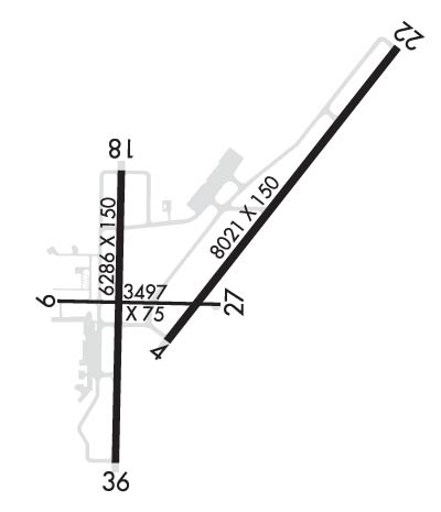 Airport Diagram might not be current. | |
| Facility Name: | EVANSVILLE RGNL |
| City Name: | EVANSVILLE |
| County: | VANDERBURGH |
| State abbrev: | IN |
| State Name: | INDIANA |
| Ownership: | PUBLICLY OWNED |
| Use: | OPEN TO THE PUBLIC |
| Owner's Name: | EVANSVLLE-VANDERBURG ARPT AUTH |
| Address: | 7801 BUSSING DR |
| EVANSVILLE, IN 47725-6799 | |
| Owner's Phone: | 812-421-4401 |
| Manager's Name: | NATE HAHN |
| Address: | 7801 BUSSING DR |
| EVANSVILLE, IN 47725-6799 | |
| Phone: | 812-421-4401 |
| FAA Region: | GREAT LAKES |
| FAA Field Office: | CHI |
| Date | Sunrise | Sunset |
|---|---|---|
| 09/24/21 Friday | 6:39 | 18:44 |
| 09/25/21 Saturday | 6:40 | 18:43 |
| 09/26/21 Sunday | 6:41 | 18:41 |
| 09/27/21 Monday | 6:42 | 18:40 |
| 09/28/21 Tuesday | 6:43 | 18:38 |
| 09/29/21 Wednesday | 6:44 | 18:37 |
| 09/30/21 Thursday | 6:45 | 18:35 |
| 10/01/21 Friday | 6:46 | 18:33 |
| 10/02/21 Saturday | 6:46 | 18:32 |
| 10/03/21 Sunday | 6:47 | 18:30 |
| 10/04/21 Monday | 6:48 | 18:29 |
| 10/05/21 Tuesday | 6:49 | 18:27 |
| 10/06/21 Wednesday | 6:50 | 18:26 |
| 10/07/21 Thursday | 6:51 | 18:24 |
| Airport Attendance Schedule | CONTINUOUS |
| Airport Status | OPERATIONAL (This Status can change at any time - please check NOTAMS) |
| Airport Lighting Schedule | ACTVT MALSR RWY 22; REIL RWY 4, 18 & 36; PAPI RWY 4; MIRL RWY 9/27; HIRL RWY 18/36 - CTAF. WHEN ATCT CLSD HIRL RWY 4/22 PRESET ON LOW INTS; TO INCR INTS - CTAF. |
| Airport Storage Available | Tie Downs, Hanger |
| Extra Services Available | Air Freight, Avionics, Charter, Flight Instruction, Aircraft Rental, Aircraft Sales |
| Wind Indicator | YES - (lighted) |
| Control Tower | YES |
| CTAF Frequency | 118.700 |
| Unicom Frequency | 122.950 |
| Rotating Beacon Color | CLEAR-GREEN (Light Land Airport) |
| Segmented Circle | YES |
| Landing Fee | NO |
| Airport Inspected | FEDERAL - performed by FAA AIRPORTS FIELD PERSONNEL |
| Inspection Date | 08/21/2019 |
| Type of Fuel Available | Grade 100LL, JET A (freeze point -40C) |
| Airframe Repair Service | MAJOR |
| Power Plant Repair Service | MAJOR |
| Latitude | N3802.4 |
| Longitude | W08731.7 (ESTIMATED) |
| Arpt Elevation | 421ft (SURVEYED) |
| Magnetic Variation | 03W |
| 3 miles N | of EVANSVILLE |
| Traffic Pattern Altitude | |
| Sectional Chart | ST LOUIS |
| Operations (Reported) | Yearly | Avg. Daily |
|---|---|---|
| General Aviation Transient | 12130 | 33 |
| General Aviation Local | 7083 | 19 |
| Air Taxi | 9927 | 27 |
| Commerical | 2397 | 7 |
| Commuter | 0 | 0 |
| Military | 1539 | 4 |
| Aircraft based on Field | |
|---|---|
| General Aviation Singles | 32 |
| General Aviation Multi | 14 |
| Jet Aircraft | 7 |
| General Aviation Helicopters | 0 |
| Military Aircraft | 0 |
| Gliders | 0 |
| Ultralights | 0 |
| FSS on field | NO |
| FSS tie-in | TERRE HAUTE |
| FSS Phone | 1-800-WX-BRIEF |
| Who issues Notams | EVV |
| Notam D service at airport | YES |
| ARTCC Name | INDIANAPOLIS |
| Airport Certification | AIRPORT RECEIVING SCHEDULED AIR CARRIER SERVICE FROM CARRIERS CERTIFICATED BY THE CIVIL AERONAUTICS BOARD; INDEX C ARFF CAPABILITY ON REQ CALL 812-421-4408. |
| Aircraft Rescue & Firefighting Index | AIRPORT HAS A CERTIFICATE UNDER CFR PART 139 |
| Airport of Entry | No |
| Custom Landing Rights | No |
| Joint Civil/Military | No |
| Military Landing rights | YES |
| NATIONAL PLAN OF INTEGRATED AIRPORT SYSTEMS (NPIAS) |
| GRANT AGREEMENTS UNDER FAAP/ADAP/AIP |
| SURPLUS PROPERTY AGREEMENT UNDER PUBLIC LAW 289 |
| SURPLUS PROPERTY AGREEMENT UNDER REGULATION 16-WAA |
| ASSURANCES PURSUANT TO TITLE VI, CIVIL RIGHTS ACT OF 1964 |
| AGREEMENT UNDER DLAND OR DCLA HAS EXPIRED. |
| BIRDS ON & INVOF ARPT. |
| TWY E LGTS OTS. |
| FOR CD WHEN ATCT CLSD CTC INDIANAPOLIS ARTCC AT 317-247-2411. |
| RWY 09/2 7 RY 09/27 & TWY E RSTRD TO ACFT LESS THAN 50,000 LBS. |
Airport Communications & Frequencies:
| |||||||||||||||||||||||||||||||||||||||||||||||
| Runway: 04 | Runway: 22 | ||
| Mag heading: | 41° | Mag heading: | 221° |
| Rwy Slope: | .49% Up | Rwy Slope: | -.49% Down |
| Approach: | ILS/DME | Approach: | ILS/DME |
| Pattern: | Left Traffic | Pattern: | Left Traffic |
| Markings: | PRECISION INSTRUMENT | Markings: | PRECISION INSTRUMENT |
| Marking Condition: | GOOD | Marking Condition: | GOOD |
| Arresting Dev: | Arresting Dev: | ||
| Lat & Long: | N3802.2 W08731.8 | Lat. & Long.: | N3803.2 W08730.8 |
| Elev: | 382.8 ft. MSL | Elev: | 421.9 ft. MSL |
| TCH: | 48 ft. AGL | TCH: | |
| Visual Glide Path: | 3.00 degrees | Visual Glide Path: | |
| Displaced Threshold: | No | Displaced Threshold: | No |
| Touchdown Zone: | YES | Touchdown Zone: | YES |
| Touchdown Elev.: | 389.1 feet | Touchdown Elev.: | 421.9 feet |
| Visual Glide Slope: | 4-Light PAPI on RIGHT side of Runway | Visual Glide Slope: | |
| RVR Equipment: | ROLLOUT | RVR Equipment: | TOUCHDOWN |
| RVV Equipment: | NO | RVV Equipment: | NO |
| Approach Lights: | Approach Lights: | MALSR - 1,400 foot medium intensity approach lighting system with runway alignment indicator lights | |
| REIL: | YES | REIL: | NO |
| Centerline Lights: | NO | Centerline Lights: | NO |
| Touchdown lights: | NO | Touchdown lights: | NO |
| Runway Category: | Precision Instrument Runway | Runway Category: | Precision Instrument Runway |
| Declared Distances: | TORA:8021' TODA:8021' ASDA:8021' LDA:8021' | Declared Distances: | TORA:8021' TODA:8021' ASDA:8021' LDA:8021' |
| Obstructions: | TREE | Obstructions: | POLE |
| Marked: | NOT Marked/Lighted | Marked: | NOT Marked/Lighted |
| Clearance slope: | 47:1 | Clearance slope: | 50:1 |
| Obstruction height: | 119 feet AGL | Obstruction height: | 43 feet AGL |
| Dist. from runway: | 5713 feet | Dist. from runway: | 2843 feet |
| Centerline offset: | 12 left of centerline | Centerline offset: | 808 feet right of centerline |
| Comments: | Comments: |
| Runway: 09 | Runway: 27 | ||
| Mag heading: | 94° | Mag heading: | 274° |
| Rwy Slope: | .06% Up | Rwy Slope: | -.06% Down |
| Approach: | Approach: | ||
| Pattern: | Left Traffic | Pattern: | Left Traffic |
| Markings: | BASIC | Markings: | BASIC |
| Marking Condition: | GOOD | Marking Condition: | GOOD |
| Arresting Dev: | Arresting Dev: | ||
| Lat & Long: | N3802.3 W08732.3 | Lat. & Long.: | N3802.3 W08731.6 |
| Elev: | 381.5 ft. MSL | Elev: | 383.5 ft. MSL |
| TCH: | TCH: | ||
| Visual Glide Path: | Visual Glide Path: | ||
| Displaced Threshold: | 529 feet | Displaced Threshold: | 218 feet |
| Touchdown Zone: | YES | Touchdown Zone: | YES |
| Touchdown Elev.: | 383.5 feet | Touchdown Elev.: | 383.0 feet |
| Visual Glide Slope: | Visual Glide Slope: | ||
| RVR Equipment: | RVR Equipment: | ||
| RVV Equipment: | NO | RVV Equipment: | NO |
| Approach Lights: | Approach Lights: | ||
| REIL: | NO | REIL: | NO |
| Centerline Lights: | NO | Centerline Lights: | NO |
| Touchdown lights: | NO | Touchdown lights: | NO |
| Runway Category: | Runway with a Visual Approach | Runway Category: | Runway with a Visual Approach |
| Declared Distances: | TORA:3497' TODA:3497' ASDA:3497' LDA:2968' | Declared Distances: | TORA:3497' TODA:3497' ASDA:3497' LDA:3279' |
| Obstructions: | ROAD | Obstructions: | ROAD |
| Marked: | NOT Marked/Lighted | Marked: | NOT Marked/Lighted |
| Clearance slope: | 12:1; APCH RATIO 20:1 AT DSPLCD THLD OVER 60 FT TREES 1400 FT FM THLD 250 FT L. | Clearance slope: | 4:1; APCH RATIO 26:1 AT DSPLCD THLD OVER 18 FT ROAD 475 FT FM THLD 13 FT LEFT. |
| Obstruction height: | 14 feet AGL | Obstruction height: | 17 feet AGL |
| Dist. from runway: | 375 feet | Dist. from runway: | 268 feet |
| Centerline offset: | 250 right of centerline | Centerline offset: | |
| Comments: | Comments: |
| Runway: 18 | Runway: 36 | ||
| Mag heading: | 184° | Mag heading: | 4° |
| Rwy Slope: | -.20% Down | Rwy Slope: | .20% Up |
| Approach: | Approach: | ||
| Pattern: | Left Traffic | Pattern: | Left Traffic |
| Markings: | PRECISION INSTRUMENT | Markings: | PRECISION INSTRUMENT |
| Marking Condition: | GOOD | Marking Condition: | GOOD |
| Arresting Dev: | Arresting Dev: | ||
| Lat & Long: | N3802.8 W08732.0 | Lat. & Long.: | N3801.7 W08732.1 |
| Elev: | 395.6 ft. MSL | Elev: | 382.8 ft. MSL |
| TCH: | 50 ft. AGL | TCH: | 29 ft. AGL |
| Visual Glide Path: | 3.00 degrees | Visual Glide Path: | 3.00 degrees |
| Displaced Threshold: | No | Displaced Threshold: | 789 feet |
| Touchdown Zone: | YES | Touchdown Zone: | YES |
| Touchdown Elev.: | 395.6 feet | Touchdown Elev.: | 384.2 feet |
| Visual Glide Slope: | 4-Light PAPI on RIGHT side of Runway | Visual Glide Slope: | 4-Light PAPI on LEFT side of Runway |
| RVR Equipment: | RVR Equipment: | ||
| RVV Equipment: | NO | RVV Equipment: | NO |
| Approach Lights: | Approach Lights: | ||
| REIL: | YES | REIL: | YES |
| Centerline Lights: | NO | Centerline Lights: | NO |
| Touchdown lights: | NO | Touchdown lights: | NO |
| Runway Category: | D | Runway Category: | D |
| Declared Distances: | TORA:5497' TODA:5497' ASDA:5497' LDA:5497' | Declared Distances: | TORA:6286' TODA:6286' ASDA:6286' LDA:5497' |
| Obstructions: | POLE | Obstructions: | ROAD |
| Marked: | LIGHTED | Marked: | NOT Marked/Lighted |
| Clearance slope: | 19:1 | Clearance slope: | 5:1; APCH RATIO 25:1 AT DSPLCD THLD OVER 51 FT LGTD BLDG 1296 FT FM THLD 308 FT LEFT; APCH RATIO 50:1 AT DSPLCD THLD OVER ROAD. |
| Obstruction height: | 64 feet AGL | Obstruction height: | 15 feet AGL |
| Dist. from runway: | 1430 feet | Dist. from runway: | 277 feet |
| Centerline offset: | 120 right of centerline | Centerline offset: | 10 feet right of centerline |
| Comments: | Comments: |
Thanks for using FltPlan.com
all rights reserved © 1999-2021 by Flight Plan LLC