
| NEWTON-CITY-COUNTY NEWTON KS |
| |
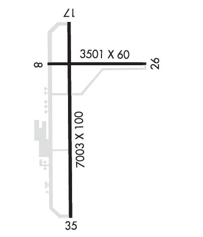
| Lat: N 3803.4 Long: W 09716.5 Elev: 1534 Var: -06 Longest Runway: 7003 | ||
| Clr Del: 126.55 AWOS: 123.87 CTAF: 123.0 | ||
| ||||||||||||||||||||||||||||||||||||||||||||
| ||||||||||||||||||||||||||||||||||||||||||||
| ||||||||||||||||||||||||||||||||||||||||||||
| Rwy | Rwy | |||||||
| 3501x60 | 3501' | 3501x60 | 3501' | |||||
| 7003x100 | 7003' | 111.70 - 174° | 7003x100 | 7003' | ||||
| Runway ID | Single Wheel | Double Wheel | Double Tandem Wheel | Dual Double Wheel |
| 08/26 | 13,000 | N/A | N/A | N/A |
| 17/35 | 50,000 | 75,000 | 135,000 | N/A |
| These numbers are Advisory and are not limits. The Airport Manager should have more accurate Weight Limits | ||||
 Airport Diagram might not be current. | |
| Facility Name: | NEWTON-CITY-COUNTY |
| City Name: | NEWTON |
| County: | HARVEY |
| State abbrev: | KS |
| State Name: | KANSAS |
| Ownership: | PUBLICLY OWNED |
| Use: | OPEN TO THE PUBLIC |
| Owner's Name: | CITY OF NEWTON HARVEY CO |
| Address: | 810 N. OLIVER ROAD - BOX 426 |
| NEWTON, KS 67114 | |
| Owner's Phone: | 316-284-6089 |
| Manager's Name: | BRIAN PALMER |
| Address: | P.O. BOX 426 |
| NEWTON, KS 67114 | |
| Phone: | 316-284-6084 |
| FAA Region: | CENTRAL |
| FAA Field Office: | NONE |
| Date | Sunrise | Sunset |
|---|---|---|
| 03/30/25 Sunday | 7:18 | 19:50 |
| 03/31/25 Monday | 7:16 | 19:51 |
| 04/01/25 Tuesday | 7:15 | 19:52 |
| 04/02/25 Wednesday | 7:13 | 19:53 |
| 04/03/25 Thursday | 7:12 | 19:54 |
| 04/04/25 Friday | 7:10 | 19:55 |
| 04/05/25 Saturday | 7:09 | 19:56 |
| 04/06/25 Sunday | 7:07 | 19:57 |
| 04/07/25 Monday | 7:06 | 19:58 |
| 04/08/25 Tuesday | 7:04 | 19:59 |
| 04/09/25 Wednesday | 7:03 | 19:59 |
| 04/10/25 Thursday | 7:01 | 20:00 |
| 04/11/25 Friday | 7:00 | 20:01 |
| 04/12/25 Saturday | 6:58 | 20:02 |
| Airport Attendance Schedule | 7 Days A Week 0700-2300; PHONE NUMBER FOR FUEL AFT HRS 316-284-6084 AND IS POSTED AT ARPT. |
| Airport Status | OPERATIONAL (This Status can change at any time - please check NOTAMS) |
| Airport Lighting Schedule | ACTVT MALSR RWY 17; REIL RWYS 08 & 26 &35; VASI RWY 35; PAPI RWYS 08 & 26 & 17; HIRL RWY 17/35 - CTAF. |
| Airport Storage Available | Tie Downs, Hanger |
| Extra Services Available | Charter, Flight Instruction, Aircraft Sales |
| Wind Indicator | YES - (lighted) |
| Control Tower | NO |
| CTAF Frequency | 123.000 |
| Unicom Frequency | 123.000 |
| Rotating Beacon Color | WG |
| Segmented Circle | NO |
| Landing Fee | NO |
| Airport Inspected | STATE - performed by STATE AERONAUTICAL PERSONNEL |
| Inspection Date | 09/28/2022 |
| Type of Fuel Available | Grade 100LL, JET A (freeze point -40C) |
| Airframe Repair Service | MAJOR |
| Power Plant Repair Service | MAJOR |
| Latitude | N3803.4 |
| Longitude | W09716.5 (ESTIMATED) |
| Arpt Elevation | 1533ft (ESTIMATED) |
| Magnetic Variation | 06E |
| 3 miles E | of NEWTON |
| Traffic Pattern Altitude | |
| Sectional Chart | WICHITA |
| Operations (Reported) | Yearly | Avg. Daily |
|---|---|---|
| General Aviation Transient | 0 | 0 |
| General Aviation Local | 0 | 0 |
| Air Taxi | 0 | 0 |
| Commerical | 0 | 0 |
| Commuter | 0 | 0 |
| Military | 0 | 0 |
| Aircraft based on Field | |
|---|---|
| General Aviation Singles | 0 |
| General Aviation Multi | 0 |
| Jet Aircraft | 0 |
| General Aviation Helicopters | 0 |
| Military Aircraft | 0 |
| Gliders | 0 |
| Ultralights | 0 |
| FSS on field | NO |
| FSS tie-in | WICHITA |
| FSS Phone | 1-800-WX-BRIEF |
| Who issues Notams | EWK |
| Notam D service at airport | YES |
| ARTCC Name | KANSAS CITY |
| Airport Certification | |
| Aircraft Rescue & Firefighting Index | None |
| Airport of Entry | No |
| Custom Landing Rights | No |
| Joint Civil/Military | No |
| Military Landing rights | YES |
| NATIONAL PLAN OF INTEGRATED AIRPORT SYSTEMS (NPIAS) |
| GRANT AGREEMENTS UNDER FAAP/ADAP/AIP |
| SURPLUS PROPERTY AGREEMENT UNDER PUBLIC LAW 289 |
| ASSURANCES PURSUANT TO TITLE VI, CIVIL RIGHTS ACT OF 1964 |
| TOUCHDOWN AREA OF RY 26 IS NOT VISIBLE FRM TOUCHDOWN AREA OF EITHER RY 17 OR RY 35. |
| SELF-SERVE AIRCRAFT WASH BAY. |
| COMPASS ROSE RIGHT OF APCH END RY 35 |
| FOR CD CTC WICHITA APCH AT 316-350-1520. |
| RWY 08/2 6 RWY 08/26 60 FT WIDE ASPHALT. |
Airport Communications & Frequencies:
| ||||||||||||||||
| Runway: 08 | Runway: 26 | ||
| Mag heading: | 84° | Mag heading: | 264° |
| Rwy Slope: | -.01% Down | Rwy Slope: | .01% Up |
| Approach: | Approach: | ||
| Pattern: | Left Traffic | Pattern: | Left Traffic |
| Markings: | BASIC | Markings: | BASIC |
| Marking Condition: | GOOD | Marking Condition: | GOOD |
| Arresting Dev: | Arresting Dev: | ||
| Lat & Long: | N3803.6 W09716.7 | Lat. & Long.: | N3803.6 W09716.0 |
| Elev: | 1533.5 ft. MSL | Elev: | 1533.3 ft. MSL |
| TCH: | 29 ft. AGL | TCH: | 29 ft. AGL |
| Visual Glide Path: | 3.00 degrees | Visual Glide Path: | 3.00 degrees |
| Displaced Threshold: | No | Displaced Threshold: | No |
| Touchdown Zone: | YES | Touchdown Zone: | YES |
| Touchdown Elev.: | 1533.5 feet | Touchdown Elev.: | 1533.3 feet |
| Visual Glide Slope: | 4-Light PAPI on LEFT side of Runway; RWY 08 PAPI OTS. | Visual Glide Slope: | 4-Light PAPI on LEFT side of Runway |
| RVR Equipment: | RVR Equipment: | ||
| RVV Equipment: | NO | RVV Equipment: | NO |
| Approach Lights: | Approach Lights: | ||
| REIL: | YES | REIL: | YES |
| Centerline Lights: | NO | Centerline Lights: | NO |
| Touchdown lights: | NO | Touchdown lights: | NO |
| Runway Category: | Runway with a Visual Approach | Runway Category: | Runway with a Visual Approach |
| Declared Distances: | TORA:3501' TODA:3501' ASDA:3501' LDA:3501' | Declared Distances: | TORA:3501' TODA:3501' ASDA:3501' LDA:3501' |
| Obstructions: | Obstructions: | POLE | |
| Marked: | Marked: | NOT Marked/Lighted | |
| Clearance slope: | 20:1 | Clearance slope: | 18:1 |
| Obstruction height: | Obstruction height: | 34 feet AGL | |
| Dist. from runway: | Dist. from runway: | 841 feet | |
| Centerline offset: | Centerline offset: | 272 feet right of centerline | |
| Comments: | Comments: |
| Runway: 17 | Runway: 35 | ||
| Mag heading: | 174° | Mag heading: | 354° |
| Rwy Slope: | -.06% Down | Rwy Slope: | .06% Up |
| Approach: | ILS | Approach: | |
| Pattern: | Left Traffic | Pattern: | Left Traffic |
| Markings: | PRECISION INSTRUMENT | Markings: | NONPRECISION INSTRUMENT |
| Marking Condition: | GOOD | Marking Condition: | GOOD |
| Arresting Dev: | Arresting Dev: | ||
| Lat & Long: | N3803.9 W09716.6 | Lat. & Long.: | N3802.7 W09716.6 |
| Elev: | 1528.8 ft. MSL | Elev: | 1524.5 ft. MSL |
| TCH: | 53 ft. AGL | TCH: | 50 ft. AGL |
| Visual Glide Path: | 3.00 degrees | Visual Glide Path: | 3.00 degrees |
| Displaced Threshold: | No | Displaced Threshold: | No |
| Touchdown Zone: | YES | Touchdown Zone: | YES |
| Touchdown Elev.: | 1530.2 feet | Touchdown Elev.: | 1527.7 feet |
| Visual Glide Slope: | 2-Light PAPI on LEFT side of Runway | Visual Glide Slope: | 4-BOX VASI ON LEFT SIDE OF RUNWAY |
| RVR Equipment: | RVR Equipment: | ||
| RVV Equipment: | NO | RVV Equipment: | NO |
| Approach Lights: | MALSR - 1,400 foot medium intensity approach lighting system with runway alignment indicator lights | Approach Lights: | |
| REIL: | NO | REIL: | YES |
| Centerline Lights: | NO | Centerline Lights: | NO |
| Touchdown lights: | NO | Touchdown lights: | NO |
| Runway Category: | Precision Instrument Runway | Runway Category: | D |
| Declared Distances: | TORA:7003' TODA:7003' ASDA:6705' LDA:6705' | Declared Distances: | TORA:7003' TODA:7003' ASDA:7003' LDA:7003' |
Thanks for using FltPlan.com
all rights reserved © 1999-2025 by Flight Plan LLC