
| FORT LAUDERDALE/HOLLYWOOD INTL FORT LAUDERDALE FL |
| |
| Lat: N 2604.3 Long: W 08009.0 Elev: 65 Var: +06 Longest Runway: 9000 | ||
| Clr Del: 128.4 Dept. ATIS: 135.0 Arr. ATIS: 135.0 Ground: 121.4/121.7 Tower: 119.3/120.2 | ||

| |||||||||||||||||||||||||||||||||||||||||||||||||||||||||||||||||||||
| |||||||||||||||||||||||||||||||||||||||||||||||||||||||||||||||||||||
| |||||||||||||||||||||||||||||||||||||||||||||||||||||||||||||||||||||
| |||||||||||||||||||||||||||||||||||||||||||||||||||||||||||||||||||||
| |||||||||||||||||||||||||||||||||||||||||||||||||||||||||||||||||||||
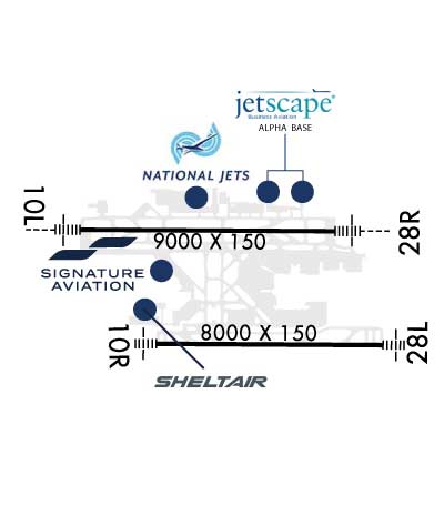
| FBOs at nearby airports who want your business: | |||||||||||||||||
| |||||||||||||||||
| Rwy | Rwy | |||||||
| 9000x150 | 8424' | 110.10 - 096° | 9000x150 | 8394' | 110.70 - 276° | |||
| 8000x150 | 8000' | 111.75 - 096° | 8000x150 | 8000' | 111.75 - 276° | |||
| Runway ID | Single Wheel | Double Wheel | Double Tandem Wheel | Dual Double Wheel |
| 10L/28R | 100,000 | 200,000 | 468,000 | 800,000 |
| 10R/28L | 120,000 | 247,000 | 461,000 | 987,000 |
| These numbers are Advisory and are not limits. The Airport Manager should have more accurate Weight Limits | ||||
 Airport Diagram might not be current. | |
| Facility Name: | FORT LAUDERDALE/HOLLYWOOD INTL |
| City Name: | FORT LAUDERDALE |
| County: | BROWARD |
| State abbrev: | FL |
| State Name: | FLORIDA |
| Ownership: | PUBLICLY OWNED |
| Use: | OPEN TO THE PUBLIC |
| Owner's Name: | BROWARD COUNTY |
| Address: | 115 S. ANDREWS AVENUE, ROOM 421 |
| DANIA BEACH, FL 33312-1872 | |
| Owner's Phone: | 954-359-6100 |
| Manager's Name: | MARK GALE |
| Address: | 320 TERMINAL DRIVE SUITE 200 |
| FORT LAUDERDALE, FL 33315 | |
| Phone: | 954-359-6100 |
| FAA Region: | SOUTHERN |
| FAA Field Office: | ORL |
| Date | Sunrise | Sunset |
|---|---|---|
| 04/27/25 Sunday | 6:47 | 19:50 |
| 04/28/25 Monday | 6:46 | 19:51 |
| 04/29/25 Tuesday | 6:45 | 19:51 |
| 04/30/25 Wednesday | 6:44 | 19:52 |
| 05/01/25 Thursday | 6:44 | 19:52 |
| 05/02/25 Friday | 6:43 | 19:53 |
| 05/03/25 Saturday | 6:42 | 19:53 |
| 05/04/25 Sunday | 6:41 | 19:54 |
| 05/05/25 Monday | 6:41 | 19:54 |
| 05/06/25 Tuesday | 6:40 | 19:55 |
| 05/07/25 Wednesday | 6:39 | 19:55 |
| 05/08/25 Thursday | 6:39 | 19:56 |
| 05/09/25 Friday | 6:38 | 19:56 |
| 05/10/25 Saturday | 6:37 | 19:57 |
| Airport Attendance Schedule | CONTINUOUS |
| Airport Status | OPERATIONAL (This Status can change at any time - please check NOTAMS) |
| Airport Lighting Schedule | SS-SR |
| Airport Storage Available | Tie Downs, Hanger |
| Extra Services Available | Air Freight, Air Ambulance, Avionics, Cargo Handling, Charter, Flight Instruction, Aircraft Rental, Aircraft Sales, Annual Surveying |
| Wind Indicator | YES - (unlit) |
| Control Tower | YES |
| CTAF Frequency | |
| Unicom Frequency | 122.950 |
| Rotating Beacon Color | WG |
| Segmented Circle | NO |
| Landing Fee | NO |
| Airport Inspected | FEDERAL - performed by FAA AIRPORTS FIELD PERSONNEL |
| Inspection Date | 02/10/2025 |
| Type of Fuel Available | Grade 100LL, JET A (freeze point -40C) |
| Airframe Repair Service | MAJOR |
| Power Plant Repair Service | MAJOR |
| Latitude | N2604.3 |
| Longitude | W08009.0 (ESTIMATED) |
| Arpt Elevation | 65ft (SURVEYED) |
| Magnetic Variation | 06W |
| 3 miles SW | of FORT LAUDERDALE |
| Traffic Pattern Altitude | |
| Sectional Chart | MIAMI |
| Operations (Reported) | Yearly | Avg. Daily |
|---|---|---|
| General Aviation Transient | 0 | 0 |
| General Aviation Local | 0 | 0 |
| Air Taxi | 0 | 0 |
| Commerical | 0 | 0 |
| Commuter | 0 | 0 |
| Military | 0 | 0 |
| Aircraft based on Field | |
|---|---|
| General Aviation Singles | 0 |
| General Aviation Multi | 0 |
| Jet Aircraft | 0 |
| General Aviation Helicopters | 0 |
| Military Aircraft | 0 |
| Gliders | 0 |
| Ultralights | 0 |
| FSS on field | NO |
| FSS tie-in | MIAMI |
| FSS Phone | 1-800-WX-BRIEF |
| Who issues Notams | FLL |
| Notam D service at airport | YES |
| ARTCC Name | MIAMI |
| Airport Certification | AIRPORT RECEIVING SCHEDULED AIR CARRIER SERVICE FROM CARRIERS CERTIFICATED BY THE CIVIL AERONAUTICS BOARD |
| Aircraft Rescue & Firefighting Index | AIRPORT HAS A CERTIFICATE UNDER CFR PART 139 |
| Airport of Entry | YES |
| Custom Landing Rights | No |
| Joint Civil/Military | No |
| Military Landing rights | YES |
| NATIONAL PLAN OF INTEGRATED AIRPORT SYSTEMS (NPIAS) |
| GRANT AGREEMENTS UNDER FAAP/ADAP/AIP |
| SURPLUS PROPERTY AGREEMENT UNDER PUBLIC LAW 289 |
| CONVEYANCE UNDER SCETION 16, FEDERAL AIRPORT ACT OF 1946 OR SECTION 23, AIRPORT AND AIRWAY DEVELOPMENT ACT OF 1970 |
| ASSURANCES PURSUANT TO TITLE VI, CIVIL RIGHTS ACT OF 1964 |
| CLSD TO ACR TRAINING. |
| PPR FOR ACFT WITH EXPLOSIVES. |
| TWY E BTN TWY C & TWY L CLSD TO ACFT WINGSPAN MORE THAN 118 FT EXC 10 MIN PPR 954-816-3179. |
| ARR FM N & W MNTN 6000 FT UNTIL ABM RWY 28R ON DOWNWIND; ARR FM N MNTN 6000 FT UNTIL ABM RWY 10L ON DOWNWIND. |
| NO VFR APCHS OR BASE LEGS UNTIL OFFSHORE. |
| IR CARRIER ACFT USE RAMP PUSH BACK PROCS PRESCRIBED BY ARPT OPS. |
| EAST SIDE OF CONCOURSE B AVBL TO ACFT WITH WINGSPAN LESS THAN 124.9 FT. |
| ACFT OPRG FROM TRML 1, 2, 3, 4 MUST CTC RAMP CTL. RAMP CTL EFF - CTC ARPT OPS FOR HRS. |
| TURB BLW 1000 FT OVR LANDFILL LCTD 2 NM W. |
| ALL RWYS NOISE SENSITIVE; NOISE ABATEMENT IN EFCT - 954-359-6181. |
| TWY J BGN TO ELEV 900 FT EAST OF TWY Q. DUE TO ELEV ALL ACFT REMAIN ON CNTRLN; TWY T8 & TAXILANE T NOT ACCESSIBLE FM TWY J. |
| RWY STATUS LIGHTS IN OPRN. |
| ACFT LDG RWY 10R & EXITING J9 FOLLOW TWY LEAD OFF LINE ONTO J9. |
| PREFERENTIAL RWY USE PROGRAM IN EFCT; CTC NOISE ABATEMENT OFFICE. |
| NMRS TREES SW QUADRANT OF ARPT. |
| HIGH LIGHT MASTS WNW APCH END RWY 28L. |
| APN TWY T EAST OF TWY T8 CLSD TO ACFT WINGSPAN MORE THAN 118 FT AND TAIL HEIGHT MORE THAN 45FT EXC ACFT UNDER TOW. |
| TXL T BTN T7 AND T8 CLSD TO ACFT WINGSPAN MORE THAN 171 FT. |
| JET RUNUPS NA 2300-0700. |
| DO NOT MISTAKE TWY B FOR LNDG/TKOF SFC. |
| TWY A BTN TWY A2 & TWY A3 CLSD TO ACFT WINGSPAN MORE THAN 171 FT & TAIL HGT MORE THAN 60 FT EXC PPR 954-816-3179. |
| RWY 10L/28R NRS UNGROOVED AREAS. |
| DO NOT MISTAKE TAXIWAY B FOR LANDING/TAKEOFF SURFACE. |
| TWY B E OF TWY B12 & TXL T E OF TWY T1 CLSD TO ACFT WITH WINGSPAN GTR THAN 118 FT & TAIL HGT GTR THAN 45 FT EXC PPR 954-816-3179. |
| BIRDS ON & INVOF ARPT; CONCENTRATION OF BIRDS BLW 500 FT 2.0 NM W OF 10L & 10R AER. |
| RWY 10R/ 28LRWY 10R/28L NRS UNGROOVED AREAS. |
| RWY 10L/ 28RST 175 |
| RWY 10L/ 28RPCR VALUE: 930/R/A/W/T |
| RWY 10R/ 28LPCR VALUE: 820/R/A/W/T |
Airport Communications & Frequencies:
| |||||||||||||||||||||||||||||||||||||||||||||||||||||||||||||||
| Runway: 10L | Runway: 28R | ||
| Mag heading: | 96° | Mag heading: | 276° |
| Rwy Slope: | .00% Down | Rwy Slope: | .00% Up |
| Approach: | ILS/DME | Approach: | ILS/DME |
| Pattern: | Left Traffic | Pattern: | Right Traffic |
| Markings: | PRECISION INSTRUMENT | Markings: | PRECISION INSTRUMENT |
| Marking Condition: | GOOD | Marking Condition: | GOOD |
| Arresting Dev: | EMAS; ARSTG GEAR/SYS: ENGRD MTRLS ARSTG SYS (EMAS) 409 FT IN LEN BY 170 FT IN WID AT THE DEP END OF RWY 10L. | Arresting Dev: | EMAS; ARSTG GEAR/SYS: ENGRD MTRLS ARSTG SYS (EMAS) 251 FT IN LEN BY 170 FT IN WID AT THE DEP END OF RWY 28R. |
| Lat & Long: | N2604.6 W08010.0 | Lat. & Long.: | N2604.6 W08008.3 |
| Elev: | 5.6 ft. MSL | Elev: | 5.3 ft. MSL |
| TCH: | 66 ft. AGL | TCH: | 69 ft. AGL |
| Visual Glide Path: | 3.00 degrees | Visual Glide Path: | 3.00 degrees |
| Displaced Threshold: | 576 feet | Displaced Threshold: | 606 feet |
| Touchdown Zone: | YES | Touchdown Zone: | YES |
| Touchdown Elev.: | 7.1 feet | Touchdown Elev.: | 6.7 feet |
| Visual Glide Slope: | 4-Light PAPI on LEFT side of Runway | Visual Glide Slope: | 4-Light PAPI on LEFT side of Runway |
| RVR Equipment: | TOUCHDOWN | RVR Equipment: | TOUCHDOWN |
| RVV Equipment: | NO | RVV Equipment: | NO |
| Approach Lights: | MALSR - 1,400 foot medium intensity approach lighting system with runway alignment indicator lights | Approach Lights: | MALSR - 1,400 foot medium intensity approach lighting system with runway alignment indicator lights |
| REIL: | NO | REIL: | NO |
| Centerline Lights: | NO | Centerline Lights: | NO |
| Touchdown lights: | NO | Touchdown lights: | NO |
| Runway Category: | Precision Instrument Runway | Runway Category: | Precision Instrument Runway |
| Declared Distances: | TORA:9000' TODA:9000' ASDA:9000' LDA:8424' | Declared Distances: | TORA:9000' TODA:9000' ASDA:9000' LDA:8394' |
| Obstructions: | ROAD | Obstructions: | RR |
| Marked: | NOT Marked/Lighted | Marked: | NOT Marked/Lighted |
| Clearance slope: | 10:1; APCH RATIO 50:1 TO DSPLCD THR. | Clearance slope: | 8:1; APCH RATIO 32:1 TO DSPLCD THR; +43 FT LGTD POLE 1414 FT FM THR 75 FT R; APCH RATIO 46:1. |
| Obstruction height: | 14 feet AGL | Obstruction height: | 33 feet AGL |
| Dist. from runway: | 340 feet | Dist. from runway: | 470 feet |
| Centerline offset: | Centerline offset: | 530 feet right of centerline | |
| Comments: | +8 FT FENCE 200 FT FM THR & 400 FT R; 40 FT LGT POLES PARL TO RWY BTN TWY Q & A-4 650 FT N. | Comments: |
| Runway: 10R | Runway: 28L | ||
| Mag heading: | 96° | Mag heading: | 276° |
| Rwy Slope: | .69% Up | Rwy Slope: | -.69% Down |
| Approach: | ILS/DME | Approach: | ILS/DME |
| Pattern: | Right Traffic | Pattern: | Left Traffic |
| Markings: | PRECISION INSTRUMENT | Markings: | PRECISION INSTRUMENT |
| Marking Condition: | GOOD | Marking Condition: | GOOD |
| Arresting Dev: | EMAS; ARSTG GEAR/SYS: ENGRD MTRLS ARSTG SYS (EMAS) 562.9 FT IN LEN BY 178.2 FT IN WID AT THE DEP END OF RWY 10R. | Arresting Dev: | EMAS; ARSTG GEAR/SYS: ENGRD MTRLS ARSTG SYS (EMAS) 562.9 FT IN LEN BY 178.2 FT IN WID AT THE DEP END OF RWY 28L. |
| Lat & Long: | N2604.0 W08009.5 | Lat. & Long.: | N2603.9 W08008.0 |
| Elev: | 10.1 ft. MSL | Elev: | 65.0 ft. MSL |
| TCH: | 71 ft. AGL | TCH: | 69 ft. AGL |
| Visual Glide Path: | 3.00 degrees | Visual Glide Path: | 3.00 degrees |
| Displaced Threshold: | No | Displaced Threshold: | No |
| Touchdown Zone: | YES | Touchdown Zone: | YES |
| Touchdown Elev.: | 14.3 feet | Touchdown Elev.: | 65.0 feet |
| Visual Glide Slope: | 4-Light PAPI on RIGHT side of Runway | Visual Glide Slope: | 4-Light PAPI on LEFT side of Runway |
| RVR Equipment: | TOUCHDOWN | RVR Equipment: | TOUCHDOWN |
| RVV Equipment: | NO | RVV Equipment: | NO |
| Approach Lights: | MALSF - 1,400 foot medium intensity approach lighting system with sequenced flashers; RWY 10R MALSF NSTD; 370 FT GAP BTN 8+00 & STATION 11+70. | Approach Lights: | MALSF - 1,400 foot medium intensity approach lighting system with sequenced flashers |
| REIL: | NO | REIL: | NO |
| Centerline Lights: | NO | Centerline Lights: | NO |
| Touchdown lights: | NO | Touchdown lights: | NO |
| Runway Category: | Precision Instrument Runway | Runway Category: | Precision Instrument Runway |
| Declared Distances: | TORA:8000' TODA:8000' ASDA:8000' LDA:8000' | Declared Distances: | TORA:8000' TODA:8000' ASDA:8000' LDA:8000' |
| Obstructions: | POLE | Obstructions: | |
| Marked: | LIGHTED | Marked: | |
| Clearance slope: | 18:1 | Clearance slope: | 50:1 |
| Obstruction height: | 35 feet AGL | Obstruction height: | |
| Dist. from runway: | 865 feet | Dist. from runway: | |
| Centerline offset: | 587 left of centerline | Centerline offset: | |
| Comments: | Comments: |
Thanks for using FltPlan.com
all rights reserved © 1999-2025 by Flight Plan LLC