
| FORT SMITH RGNL FORT SMITH AR |
| |
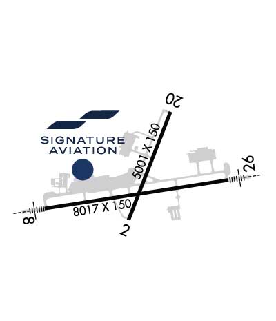
| Lat: N 3520.2 Long: W 09422.0 Elev: 469 Var: -05 Longest Runway: 8017 | ||
| Clr Del: 133.85 Dept. ATIS: 126.3 Arr. ATIS: 126.3 AWOS: 126.3 Ground: 121.9 Tower: 118.3 | ||
| |||||||||||||||||||||||||||||||||||||||||||||||||||||||||||||||||||||
| |||||||||||||||||||||||||||||||||||||||||||||||||||||||||||||||||||||
| |||||||||||||||||||||||||||||||||||||||||||||||||||||||||||||||||||||
| Rwy | Rwy | |||||||
| 5001x150 | 5001' | 5001x150 | 5001' | |||||
| 8017x150 | 8017' | 111.30 - 076° | 8017x150 | 8017' | 111.30 - 256° | |||
| Runway ID | Single Wheel | Double Wheel | Double Tandem Wheel | Dual Double Wheel |
| 01/19 | 55,000 | 70,000 | 120,000 | N/A |
| 07/25 | 75,000 | 175,000 | 295,000 | N/A |
| These numbers are Advisory and are not limits. The Airport Manager should have more accurate Weight Limits | ||||
 Airport Diagram might not be current. | |
| Facility Name: | FORT SMITH RGNL |
| City Name: | FORT SMITH |
| County: | SEBASTIAN |
| State abbrev: | AR |
| State Name: | ARKANSAS |
| Ownership: | PUBLICLY OWNED |
| Use: | OPEN TO THE PUBLIC |
| Owner's Name: | FORT SMITH ARPT COMMISSION |
| Address: | 6700 MCKENNON BLVD SUITE 200 |
| FORT SMITH, AR 72903 | |
| Owner's Phone: | 479-452-7000 |
| Manager's Name: | MICHAEL GRIFFIN; MICHAEL@FORTSMITHAIRPORT.COM |
| Address: | 6700 MC KENNON BLVD SUITE 200 |
| FORT SMITH, AR 72903 | |
| Phone: | 479-452-7000 |
| FAA Region: | SOUTHWEST |
| FAA Field Office: | AOK |
| Date | Sunrise | Sunset |
|---|---|---|
| 09/24/21 Friday | 7:07 | 19:12 |
| 09/25/21 Saturday | 7:08 | 19:10 |
| 09/26/21 Sunday | 7:08 | 19:09 |
| 09/27/21 Monday | 7:09 | 19:07 |
| 09/28/21 Tuesday | 7:10 | 19:06 |
| 09/29/21 Wednesday | 7:11 | 19:04 |
| 09/30/21 Thursday | 7:11 | 19:03 |
| 10/01/21 Friday | 7:12 | 19:02 |
| 10/02/21 Saturday | 7:13 | 19:00 |
| 10/03/21 Sunday | 7:14 | 18:59 |
| 10/04/21 Monday | 7:14 | 18:57 |
| 10/05/21 Tuesday | 7:15 | 18:56 |
| 10/06/21 Wednesday | 7:16 | 18:55 |
| 10/07/21 Thursday | 7:17 | 18:53 |
| Airport Attendance Schedule | CONTINUOUS |
| Airport Status | OPERATIONAL (This Status can change at any time - please check NOTAMS) |
| Airport Lighting Schedule | WHEN ATCT CLSD ACTVT HIRL RY 07/25; MIRL RY 01/19; MALSR RYS 07 & 25 - CTAF. |
| Airport Storage Available | Tie Downs, Hanger |
| Extra Services Available | Air Freight, Avionics, Charter, Flight Instruction |
| Wind Indicator | YES - (lighted) |
| Control Tower | YES |
| CTAF Frequency | 118.300 |
| Unicom Frequency | 122.950 |
| Rotating Beacon Color | CLEAR-GREEN (Light Land Airport) |
| Segmented Circle | YES |
| Landing Fee | NO |
| Airport Inspected | FEDERAL - performed by FAA AIRPORTS FIELD PERSONNEL |
| Inspection Date | 07/22/2021 |
| Type of Fuel Available | Grade 100LL, JET A (freeze point -40C); -10100LL AVBL 24 HRS SELF SERVE. FOR JET A SAT & SUN 2200-0600, CALL 479-646-1611. |
| Airframe Repair Service | MAJOR |
| Power Plant Repair Service | MAJOR |
| Latitude | N3520.2 |
| Longitude | W09422.0 (ESTIMATED) |
| Arpt Elevation | 469ft (SURVEYED) |
| Magnetic Variation | 05E |
| 3 miles SE | of FORT SMITH |
| Traffic Pattern Altitude | |
| Sectional Chart | MEMPHIS |
| Operations (Reported) | Yearly | Avg. Daily |
|---|---|---|
| General Aviation Transient | 12978 | 36 |
| General Aviation Local | 7095 | 19 |
| Air Taxi | 2802 | 8 |
| Commerical | 1048 | 3 |
| Commuter | 0 | 0 |
| Military | 7894 | 22 |
| Aircraft based on Field | |
|---|---|
| General Aviation Singles | 58 |
| General Aviation Multi | 12 |
| Jet Aircraft | 5 |
| General Aviation Helicopters | 1 |
| Military Aircraft | 0 |
| Gliders | 1 |
| Ultralights | 0 |
| FSS on field | NO |
| FSS tie-in | JONESBORO |
| FSS Phone | 1-800-WX-BRIEF |
| Who issues Notams | FSM |
| Notam D service at airport | YES |
| ARTCC Name | MEMPHIS |
| Airport Certification | AIRPORT RECEIVING SCHEDULED AIR CARRIER SERVICE FROM CARRIERS CERTIFICATED BY THE CIVIL AERONAUTICS BOARD; 24 HRS PPR FOR UNSKED ACR OPNS WITH MORE THAN 30 PSGR SEATS CALL AMGR 479-452-7000. |
| Aircraft Rescue & Firefighting Index | AIRPORT HAS A CERTIFICATE UNDER CFR PART 139 |
| Airport of Entry | No |
| Custom Landing Rights | No |
| Joint Civil/Military | No |
| Military Landing rights | YES |
| NATIONAL PLAN OF INTEGRATED AIRPORT SYSTEMS (NPIAS) |
| GRANT AGREEMENTS UNDER FAAP/ADAP/AIP |
| ASSURANCES PURSUANT TO TITLE VI, CIVIL RIGHTS ACT OF 1964 |
| RY 01 AIMING POINTS 1390 FT FM THLD. |
| FOR CD CTC MEMPHIS ARTCC AT 901-368-8453/8449. |
| LNDG FEE FOR ALL FAR 121 & FAR 135 OPNS ABOVE 12,500 LBS. |
| PPR FOR ALL ACFT (INCLUDING US GOVT) ABOVE 100,000 LBS. CTC AMGR 0800-1700 MON-FRI 479-452-7000; MINIMUM 24 HRS IN ADVANCE. |
| FLOCK OF MIGRATORY BIRDS ON & INVOF ARPT. |
Airport Communications & Frequencies:
| |||||||||||||||||||||||||||||||||||||
| Runway: 01 | Runway: 19 | ||
| Mag heading: | 16° | Mag heading: | 196° |
| Rwy Slope: | -.03% Down | Rwy Slope: | .03% Up |
| Approach: | Approach: | ||
| Pattern: | Left Traffic | Pattern: | Left Traffic |
| Markings: | NONPRECISION INSTRUMENT | Markings: | NONPRECISION INSTRUMENT |
| Marking Condition: | GOOD | Marking Condition: | GOOD |
| Arresting Dev: | Arresting Dev: | ||
| Lat & Long: | N3519.9 W09422.2 | Lat. & Long.: | N3520.7 W09421.8 |
| Elev: | 448.8 ft. MSL | Elev: | 447.4 ft. MSL |
| TCH: | 50 ft. AGL | TCH: | 40 ft. AGL |
| Visual Glide Path: | 3.00 degrees | Visual Glide Path: | 3.00 degrees |
| Displaced Threshold: | No | Displaced Threshold: | No |
| Touchdown Zone: | YES | Touchdown Zone: | YES |
| Touchdown Elev.: | 448.9 feet | Touchdown Elev.: | 447.6 feet |
| Visual Glide Slope: | 4-Light PAPI on RIGHT side of Runway; PAPI UNUSABLE 8 DEGS LEFT SIDE OF CNTRLN. | Visual Glide Slope: | 4-Light PAPI on LEFT side of Runway; PAPI UNUSABLE 5 DEGS RIGHT SIDE OF CNTRLN. |
| RVR Equipment: | RVR Equipment: | ||
| RVV Equipment: | NO | RVV Equipment: | NO |
| Approach Lights: | Approach Lights: | ||
| REIL: | NO | REIL: | NO |
| Centerline Lights: | NO | Centerline Lights: | NO |
| Touchdown lights: | NO | Touchdown lights: | NO |
| Runway Category: | Runway with a Non-precision Approach having visibility minimums greater than 3/4 mile | Runway Category: | Runway with a Visual Approach |
| Declared Distances: | TORA:5001' TODA:5001' ASDA:5001' LDA:5001' | Declared Distances: | TORA:5001' TODA:5001' ASDA:5001' LDA:5001' |
| Obstructions: | RR | Obstructions: | TREE |
| Marked: | NOT Marked/Lighted | Marked: | NOT Marked/Lighted |
| Clearance slope: | 20:1 | Clearance slope: | 23:1 |
| Obstruction height: | 21 feet AGL | Obstruction height: | 56 feet AGL |
| Dist. from runway: | 640 feet | Dist. from runway: | 1495 feet |
| Centerline offset: | 313 right of centerline | Centerline offset: | 365 feet right of centerline |
| Comments: | Comments: |
| Runway: 07 | Runway: 25 | ||
| Mag heading: | 76° | Mag heading: | 256° |
| Rwy Slope: | -.32% Down | Rwy Slope: | .32% Up |
| Approach: | ILS | Approach: | ILS |
| Pattern: | Left Traffic | Pattern: | Left Traffic |
| Markings: | PRECISION INSTRUMENT | Markings: | PRECISION INSTRUMENT |
| Marking Condition: | GOOD | Marking Condition: | GOOD |
| Arresting Dev: | Arresting Dev: | ||
| Lat & Long: | N3520.0 W09422.9 | Lat. & Long.: | N3520.2 W09421.3 |
| Elev: | 469.0 ft. MSL | Elev: | 443.5 ft. MSL |
| TCH: | 51 ft. AGL | TCH: | 58 ft. AGL |
| Visual Glide Path: | 3.00 degrees | Visual Glide Path: | 2.96 degrees |
| Displaced Threshold: | No | Displaced Threshold: | No |
| Touchdown Zone: | YES | Touchdown Zone: | YES |
| Touchdown Elev.: | 469.0 feet | Touchdown Elev.: | 453.0 feet |
| Visual Glide Slope: | 4-Light PAPI on RIGHT side of Runway | Visual Glide Slope: | 4-Light PAPI on LEFT side of Runway |
| RVR Equipment: | ROLLOUT | RVR Equipment: | TOUCHDOWN |
| RVV Equipment: | NO | RVV Equipment: | NO |
| Approach Lights: | MALSR - 1,400 foot medium intensity approach lighting system with runway alignment indicator lights | Approach Lights: | MALSR - 1,400 foot medium intensity approach lighting system with runway alignment indicator lights |
| REIL: | NO | REIL: | NO |
| Centerline Lights: | NO | Centerline Lights: | NO |
| Touchdown lights: | NO | Touchdown lights: | NO |
| Runway Category: | Precision Instrument Runway | Runway Category: | Precision Instrument Runway |
| Declared Distances: | TORA:8017' TODA:8017' ASDA:8017' LDA:8017' | Declared Distances: | TORA:8017' TODA:8017' ASDA:8017' LDA:8017' |
| Obstructions: | TREE | Obstructions: | TREE |
| Marked: | NOT Marked/Lighted | Marked: | NOT Marked/Lighted |
| Clearance slope: | 24:1 | Clearance slope: | 37:1 |
| Obstruction height: | 78 feet AGL | Obstruction height: | 100 feet AGL |
| Dist. from runway: | 2102 feet | Dist. from runway: | 3910 feet |
| Centerline offset: | 692 left of centerline | Centerline offset: | 1032 feet right of centerline |
| Comments: | Comments: |
Thanks for using FltPlan.com
all rights reserved © 1999-2021 by Flight Plan LLC