| ARLINGTON MUNI ARLINGTON TX |
| |
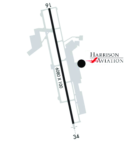
| Lat: N 3239.8 Long: W 09705.7 Elev: 628 Var: -06 Longest Runway: 6080 | ||
| Clr Del: 118.85 AWOS: 127.37 Ground: 121.87 Tower: 128.62 | ||
| |||||||||||||||||||||||||||||||||||||||||||||||||||||||||||||||||||||
| |||||||||||||||||||||||||||||||||||||||||||||||||||||||||||||||||||||
| |||||||||||||||||||||||||||||||||||||||||||||||||||||||||||||||||||||
| |||||||||||||||||||||||||||||||||||||||||||||||||||||||||||||||||||||
| FBOs at nearby airports who want your business: | |||||||||||||||||
| |||||||||||||||||
| Rwy | Rwy | |||||||
| 6080x100 | 6080' | 6080x100 | 6080' | 111.55 - 342° | ||||
| Runway ID | Single Wheel | Double Wheel | Double Tandem Wheel | Dual Double Wheel |
| 16/34 | 60,000 | N/A | N/A | N/A |
| These numbers are Advisory and are not limits. The Airport Manager should have more accurate Weight Limits | ||||
 Airport Diagram might not be current. | |
| Facility Name: | ARLINGTON MUNI |
| City Name: | ARLINGTON |
| County: | TARRANT |
| State abbrev: | TX |
| State Name: | TEXAS |
| Ownership: | PUBLICLY OWNED |
| Use: | OPEN TO THE PUBLIC |
| Owner's Name: | CITY OF ARLINGTON |
| Address: | PO BOX 90231 |
| ARLINGTON, TX 76004-3231 | |
| Owner's Phone: | 817-459-5571 |
| Manager's Name: | TRENT BALLARD |
| Address: | 5000 S. COLLINS, STE 100 |
| ARLINGTON, TX 76018-3231 | |
| Phone: | 817-459-5571 |
| FAA Region: | SOUTHWEST |
| FAA Field Office: | TEX |

| Date | Sunrise | Sunset |
|---|---|---|
| 03/30/25 Sunday | 7:19 | 19:47 |
| 03/31/25 Monday | 7:18 | 19:48 |
| 04/01/25 Tuesday | 7:17 | 19:48 |
| 04/02/25 Wednesday | 7:15 | 19:49 |
| 04/03/25 Thursday | 7:14 | 19:50 |
| 04/04/25 Friday | 7:13 | 19:50 |
| 04/05/25 Saturday | 7:12 | 19:51 |
| 04/06/25 Sunday | 7:10 | 19:52 |
| 04/07/25 Monday | 7:09 | 19:53 |
| 04/08/25 Tuesday | 7:08 | 19:53 |
| 04/09/25 Wednesday | 7:07 | 19:54 |
| 04/10/25 Thursday | 7:05 | 19:55 |
| 04/11/25 Friday | 7:04 | 19:55 |
| 04/12/25 Saturday | 7:03 | 19:56 |
| Airport Attendance Schedule | CONTINUOUS |
| Airport Status | OPERATIONAL (This Status can change at any time - please check NOTAMS) |
| Airport Lighting Schedule | MIRL RWY 16/34 PRESET MED INTST; HIGHER INTST BY ATCT REQ. WHEN ATCT CLSD ACTVT MALSR RWY 34 - CTAF. |
| Airport Storage Available | Tie Downs, Hanger |
| Extra Services Available | Avionics, Flight Instruction, Aircraft Rental, Aircraft Sales |
| Wind Indicator | YES - (lighted) |
| Control Tower | YES |
| CTAF Frequency | 128.625 |
| Unicom Frequency | |
| Rotating Beacon Color | WG |
| Segmented Circle | YES |
| Landing Fee | NO |
| Airport Inspected | STATE - performed by PRIVATE CONTRACT PERSONNEL |
| Inspection Date | 11/07/2023 |
| Type of Fuel Available | Grade 100LL, JET A (freeze point -40C); -10100LL SELF SERVE FUEL. |
| Airframe Repair Service | MAJOR |
| Power Plant Repair Service | MAJOR |
| Latitude | N3239.8 |
| Longitude | W09705.7 (ESTIMATED) |
| Arpt Elevation | 628ft (SURVEYED) |
| Magnetic Variation | 06E |
| 4 miles S | of ARLINGTON |
| Traffic Pattern Altitude | |
| Sectional Chart | DALLAS-FT WORTH |
| Operations (Reported) | Yearly | Avg. Daily |
|---|---|---|
| General Aviation Transient | 0 | 0 |
| General Aviation Local | 0 | 0 |
| Air Taxi | 0 | 0 |
| Commerical | 0 | 0 |
| Commuter | 0 | 0 |
| Military | 0 | 0 |
| Aircraft based on Field | |
|---|---|
| General Aviation Singles | 0 |
| General Aviation Multi | 0 |
| Jet Aircraft | 0 |
| General Aviation Helicopters | 0 |
| Military Aircraft | 0 |
| Gliders | 0 |
| Ultralights | 0 |
| FSS on field | NO |
| FSS tie-in | FORT WORTH |
| FSS Phone | 1-800-WX-BRIEF |
| Who issues Notams | GKY |
| Notam D service at airport | YES |
| ARTCC Name | FORT WORTH |
| Airport Certification | |
| Aircraft Rescue & Firefighting Index | None |
| Airport of Entry | No |
| Custom Landing Rights | No |
| Joint Civil/Military | No |
| Military Landing rights | YES |
| NATIONAL PLAN OF INTEGRATED AIRPORT SYSTEMS (NPIAS) |
| GRANT AGREEMENTS UNDER FAAP/ADAP/AIP |
| ASSURANCES PURSUANT TO TITLE VI, CIVIL RIGHTS ACT OF 1964 |
| THIS AIRPORT HAS BEEN SURVEYED BY THE NATIONAL GEODETIC SURVEY. |
| EXTSV HEL TFC WEST OF RWY. |
Airport Communications & Frequencies:
| ||||||||||||||||||||
| Runway: 16 | Runway: 34 | ||
| Mag heading: | 162° | Mag heading: | 342° |
| Rwy Slope: | -.51% Down | Rwy Slope: | .51% Up |
| Approach: | Approach: | ILS/DME | |
| Pattern: | Left Traffic | Pattern: | Left Traffic |
| Markings: | NONPRECISION INSTRUMENT | Markings: | PRECISION INSTRUMENT |
| Marking Condition: | GOOD | Marking Condition: | GOOD |
| Arresting Dev: | Arresting Dev: | ||
| Lat & Long: | N3240.3 W09705.8 | Lat. & Long.: | N3239.3 W09705.5 |
| Elev: | 628.2 ft. MSL | Elev: | 596.9 ft. MSL |
| TCH: | 42 ft. AGL | TCH: | 55 ft. AGL |
| Visual Glide Path: | 3.00 degrees | Visual Glide Path: | 3.00 degrees |
| Displaced Threshold: | No | Displaced Threshold: | No |
| Touchdown Zone: | YES | Touchdown Zone: | YES |
| Touchdown Elev.: | 628.2 feet | Touchdown Elev.: | 620.0 feet |
| Visual Glide Slope: | 4-Light PAPI on LEFT side of Runway | Visual Glide Slope: | 4-Light PAPI on LEFT side of Runway |
| RVR Equipment: | RVR Equipment: | ||
| RVV Equipment: | NO | RVV Equipment: | NO |
| Approach Lights: | Approach Lights: | MALSR - 1,400 foot medium intensity approach lighting system with runway alignment indicator lights | |
| REIL: | YES | REIL: | NO |
| Centerline Lights: | NO | Centerline Lights: | NO |
| Touchdown lights: | NO | Touchdown lights: | NO |
| Runway Category: | Runway with a Visual Approach | Runway Category: | Precision Instrument Runway |
| Declared Distances: | Declared Distances: |
Thanks for using FltPlan.com
all rights reserved © 1999-2025 by Flight Plan LLC