
| PIEDMONT TRIAD INTL GREENSBORO NC |
| |
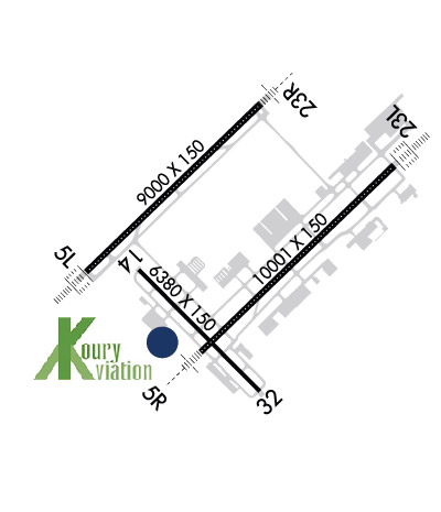
| Lat: N 3606.1 Long: W 07956.5 Elev: 926 Var: +08 Longest Runway: 10001 | ||
| Clr Del: 121.75 Dept. ATIS: 128.55 Arr. ATIS: 128.55 Ground: 121.9 Tower: 119.1 | ||

| |||||||||||||||||||||||||||||||||||||||||||||||||||||||||||||||||||||
| |||||||||||||||||||||||||||||||||||||||||||||||||||||||||||||||||||||
| |||||||||||||||||||||||||||||||||||||||||||||||||||||||||||||||||||||
| |||||||||||||||||||||||||||||||||||||||||||||||||||||||||||||||||||||
| FBOs at nearby airports who want your business: | |||||||||||||||||
| |||||||||||||||||
| |||||||||||||||||
| Rwy | Rwy | |||||||
| 9001x150 | 9001' | 109.55 - 053° | 9001x150 | 9001' | 109.55 - 233° | |||
| 10001x150 | 10001' | 111.90 - 053° | 10001x150 | 10001' | 109.30 - 234° | |||
| 6380x150 | 6380' | 109.90 - 141° | 6380x150 | 6380' | 111.15 - 325° | |||
| Runway ID | Single Wheel | Double Wheel | Double Tandem Wheel | Dual Double Wheel |
| 05L/23R | 120,000 | 250,000 | 550,000 | 1,120,000 |
| 05R/23L | 120,000 | 250,000 | 550,000 | 1,051,000 |
| 14/32 | 120,000 | 218,000 | 352,000 | N/A |
| These numbers are Advisory and are not limits. The Airport Manager should have more accurate Weight Limits | ||||
 Airport Diagram might not be current. | |
| Facility Name: | PIEDMONT TRIAD INTL |
| City Name: | GREENSBORO |
| County: | GUILFORD |
| State abbrev: | NC |
| State Name: | NORTH CAROLINA |
| Ownership: | PUBLICLY OWNED |
| Use: | OPEN TO THE PUBLIC |
| Owner's Name: | PIEDMONT TRIAD ARPT AUTH. |
| Address: | 1000A TED JOHNSON PKWY |
| GREENSBORO, NC 27409 | |
| Owner's Phone: | 336-665-5600 |
| Manager's Name: | KEVIN BAKER |
| Address: | 1000A TED JOHNSON PKWY |
| GREENSBORO, NC 27409 | |
| Phone: | 336-665-5600 |
| FAA Region: | SOUTHERN |
| FAA Field Office: | MEM |
| Date | Sunrise | Sunset |
|---|---|---|
| 09/24/21 Friday | 7:09 | 19:14 |
| 09/25/21 Saturday | 7:10 | 19:13 |
| 09/26/21 Sunday | 7:11 | 19:11 |
| 09/27/21 Monday | 7:11 | 19:10 |
| 09/28/21 Tuesday | 7:12 | 19:08 |
| 09/29/21 Wednesday | 7:13 | 19:07 |
| 09/30/21 Thursday | 7:14 | 19:05 |
| 10/01/21 Friday | 7:15 | 19:04 |
| 10/02/21 Saturday | 7:15 | 19:02 |
| 10/03/21 Sunday | 7:16 | 19:01 |
| 10/04/21 Monday | 7:17 | 18:59 |
| 10/05/21 Tuesday | 7:18 | 18:58 |
| 10/06/21 Wednesday | 7:19 | 18:57 |
| 10/07/21 Thursday | 7:20 | 18:55 |
| Airport Attendance Schedule | CONTINUOUS |
| Airport Status | OPERATIONAL (This Status can change at any time - please check NOTAMS) |
| Airport Lighting Schedule | |
| Airport Storage Available | Tie Downs, Hanger |
| Extra Services Available | Air Freight, Avionics, Cargo Handling, Charter, Flight Instruction, Aircraft Rental, Aircraft Sales |
| Wind Indicator | YES - (lighted) |
| Control Tower | YES |
| CTAF Frequency | |
| Unicom Frequency | 122.950 |
| Rotating Beacon Color | CLEAR-GREEN (Light Land Airport) |
| Segmented Circle | YES |
| Landing Fee | NO |
| Airport Inspected | FEDERAL - performed by FAA AIRPORTS FIELD PERSONNEL |
| Inspection Date | 05/04/2021 |
| Type of Fuel Available | Grade 100LL, JET A (freeze point -40C) |
| Airframe Repair Service | MAJOR |
| Power Plant Repair Service | MAJOR |
| Latitude | N3606.1 |
| Longitude | W07956.5 (ESTIMATED) |
| Arpt Elevation | 925ft (SURVEYED) |
| Magnetic Variation | 08W |
| 7 miles W | of GREENSBORO |
| Traffic Pattern Altitude | |
| Sectional Chart | CINCINNATI |
| Operations (Reported) | Yearly | Avg. Daily |
|---|---|---|
| General Aviation Transient | 23797 | 65 |
| General Aviation Local | 11879 | 33 |
| Air Taxi | 11381 | 31 |
| Commerical | 16351 | 45 |
| Commuter | 0 | 0 |
| Military | 2524 | 7 |
| Aircraft based on Field | |
|---|---|
| General Aviation Singles | 78 |
| General Aviation Multi | 12 |
| Jet Aircraft | 17 |
| General Aviation Helicopters | 0 |
| Military Aircraft | 0 |
| Gliders | 0 |
| Ultralights | 0 |
| FSS on field | NO |
| FSS tie-in | RALEIGH |
| FSS Phone | 1-800-WX-BRIEF |
| Who issues Notams | GSO |
| Notam D service at airport | YES |
| ARTCC Name | ATLANTA |
| Airport Certification | AIRPORT RECEIVING SCHEDULED AIR CARRIER SERVICE FROM CARRIERS CERTIFICATED BY THE CIVIL AERONAUTICS BOARD |
| Aircraft Rescue & Firefighting Index | AIRPORT HAS A CERTIFICATE UNDER CFR PART 139 |
| Airport of Entry | No |
| Custom Landing Rights | YES |
| Joint Civil/Military | No |
| Military Landing rights | YES |
| NATIONAL PLAN OF INTEGRATED AIRPORT SYSTEMS (NPIAS) |
| GRANT AGREEMENTS UNDER FAAP/ADAP/AIP |
| SURPLUS PROPERTY AGREEMENT UNDER REGULATION 16-WAA |
| ASSURANCES PURSUANT TO TITLE VI, CIVIL RIGHTS ACT OF 1964 |
| AGREEMENT UNDER DLAND OR DCLA HAS EXPIRED. |
| ACFT WITH WINGSPAN GREATER THAN 171 FT ARE PROHIBITED FROM USING TWY E. |
| DUE TO NOISE SENSITIVE AREAS, ACFT PERFORMING PRACTICE APPROACHES SHALL USE RWY 5R-23L. |
| TWY E PORTIONS BETWEEN TWY J AND TWY H NOT VISIBLE FROM ATCT. TWY K NORTHEAST OF TWY K6 CLSD EXCEPT FOR CARGO ACFT. |
Airport Communications & Frequencies:
| |||||||||||||||||||||||||||||||||||||||||||||||
| Runway: 05L | Runway: 23R | ||
| Mag heading: | 54° | Mag heading: | 234° |
| Rwy Slope: | -.68% Down | Rwy Slope: | .68% Up |
| Approach: | ILS/DME | Approach: | ILS/DME |
| Pattern: | Left Traffic | Pattern: | Left Traffic |
| Markings: | PRECISION INSTRUMENT | Markings: | PRECISION INSTRUMENT |
| Marking Condition: | GOOD | Marking Condition: | GOOD |
| Arresting Dev: | Arresting Dev: | ||
| Lat & Long: | N3606.0 W07957.5 | Lat. & Long.: | N3607.0 W07956.2 |
| Elev: | 916.4 ft. MSL | Elev: | 855.3 ft. MSL |
| TCH: | 69 ft. AGL | TCH: | 72 ft. AGL |
| Visual Glide Path: | 3.00 degrees | Visual Glide Path: | 3.00 degrees |
| Displaced Threshold: | No | Displaced Threshold: | No |
| Touchdown Zone: | YES | Touchdown Zone: | YES |
| Touchdown Elev.: | 916.4 feet | Touchdown Elev.: | 863.6 feet |
| Visual Glide Slope: | 4-Light PAPI on LEFT side of Runway | Visual Glide Slope: | 4-Light PAPI on LEFT side of Runway |
| RVR Equipment: | TOUCHDOWN-MIDFIELD-ROLLOUT | RVR Equipment: | TOUCHDOWN-MIDFIELD-ROLLOUT |
| RVV Equipment: | NO | RVV Equipment: | NO |
| Approach Lights: | ALSF2 - standard 2,400 foot high intensity approach lighting system with sequenced flashers, Category II or III | Approach Lights: | MALSR - 1,400 foot medium intensity approach lighting system with runway alignment indicator lights |
| REIL: | NO | REIL: | NO |
| Centerline Lights: | YES | Centerline Lights: | YES |
| Touchdown lights: | YES | Touchdown lights: | YES |
| Runway Category: | Precision Instrument Runway | Runway Category: | Precision Instrument Runway |
| Declared Distances: | TORA:9000' TODA:9000' ASDA:9000' LDA:9000' | Declared Distances: | TORA:9000' TODA:9000' ASDA:9000' LDA:9000' |
| Runway: 05R | Runway: 23L | ||
| Mag heading: | 54° | Mag heading: | 234° |
| Rwy Slope: | -.14% Down | Rwy Slope: | .14% Up |
| Approach: | ILS/DME | Approach: | ILS |
| Pattern: | Left Traffic | Pattern: | Left Traffic |
| Markings: | PRECISION INSTRUMENT | Markings: | PRECISION INSTRUMENT |
| Marking Condition: | GOOD | Marking Condition: | GOOD |
| Arresting Dev: | Arresting Dev: | ||
| Lat & Long: | N3605.5 W07956.7 | Lat. & Long.: | N3606.6 W07955.2 |
| Elev: | 899.5 ft. MSL | Elev: | 885.8 ft. MSL |
| TCH: | 69 ft. AGL | TCH: | 55 ft. AGL |
| Visual Glide Path: | 3.00 degrees | Visual Glide Path: | 3.00 degrees |
| Displaced Threshold: | No | Displaced Threshold: | No |
| Touchdown Zone: | YES | Touchdown Zone: | YES |
| Touchdown Elev.: | 900.3 feet | Touchdown Elev.: | 889.4 feet |
| Visual Glide Slope: | 4-Light PAPI on RIGHT side of Runway | Visual Glide Slope: | 4-Light PAPI on LEFT side of Runway |
| RVR Equipment: | TOUCHDOWN-MIDFIELD-ROLLOUT | RVR Equipment: | TOUCHDOWN-MIDFIELD-ROLLOUT |
| RVV Equipment: | NO | RVV Equipment: | NO |
| Approach Lights: | MALSR - 1,400 foot medium intensity approach lighting system with runway alignment indicator lights | Approach Lights: | ALSF2 - standard 2,400 foot high intensity approach lighting system with sequenced flashers, Category II or III |
| REIL: | NO | REIL: | NO |
| Centerline Lights: | YES | Centerline Lights: | YES |
| Touchdown lights: | NO | Touchdown lights: | YES |
| Runway Category: | Precision Instrument Runway | Runway Category: | Precision Instrument Runway |
| Declared Distances: | TORA:10001' TODA:10001' ASDA:10001' LDA:10001' | Declared Distances: | TORA:10001' TODA:10001' ASDA:9601' LDA:9601' |
| Runway: 14 | Runway: 32 | ||
| Mag heading: | 143° | Mag heading: | 323° |
| Rwy Slope: | -.40% Down | Rwy Slope: | .40% Up |
| Approach: | ILS | Approach: | ILS/DME |
| Pattern: | Left Traffic | Pattern: | Left Traffic |
| Markings: | PRECISION INSTRUMENT | Markings: | PRECISION INSTRUMENT |
| Marking Condition: | GOOD | Marking Condition: | GOOD |
| Arresting Dev: | Arresting Dev: | ||
| Lat & Long: | N3606.0 W07957.1 | Lat. & Long.: | N3605.2 W07956.2 |
| Elev: | 925.4 ft. MSL | Elev: | 900.0 ft. MSL |
| TCH: | TCH: | 53 ft. AGL | |
| Visual Glide Path: | Visual Glide Path: | 3.00 degrees | |
| Displaced Threshold: | No | Displaced Threshold: | No |
| Touchdown Zone: | YES | Touchdown Zone: | YES |
| Touchdown Elev.: | 925.5 feet | Touchdown Elev.: | 902.1 feet |
| Visual Glide Slope: | Visual Glide Slope: | 4-Light PAPI on LEFT side of Runway | |
| RVR Equipment: | RVR Equipment: | ||
| RVV Equipment: | NO | RVV Equipment: | NO |
| Approach Lights: | Approach Lights: | ||
| REIL: | NO | REIL: | YES |
| Centerline Lights: | NO | Centerline Lights: | NO |
| Touchdown lights: | NO | Touchdown lights: | NO |
| Runway Category: | Precision Instrument Runway | Runway Category: | Precision Instrument Runway |
| Declared Distances: | TORA:6380' TODA:6380' ASDA:6380' LDA:6380' | Declared Distances: | TORA:6380' TODA:6380' ASDA:6380' LDA:6380' |
Thanks for using FltPlan.com
all rights reserved © 1999-2021 by Flight Plan LLC