
| GEORGETOWN MUNI GEORGETOWN TX |
| |
| Lat: N 3040.7 Long: W 09740.8 Elev: 790 Var: -06 Longest Runway: 5004 | ||
| Clr Del: 121.1 TW CLD Dept. ATIS: 118.6 Arr. ATIS: 118.6 AWOS: 118.6 Ground: 119.12 Tower: 120.22 | ||
| |||||||||||||||||||||||||||||||||||||||||||||||||||||||||||||||||||||
| |||||||||||||||||||||||||||||||||||||||||||||||||||||||||||||||||||||
| |||||||||||||||||||||||||||||||||||||||||||||||||||||||||||||||||||||
| |||||||||||||||||||||||||||||||||||||||||||||||||||||||||||||||||||||
| |||||||||||||||||||||||||||||||||||||||||||||||||||||||||||||||||||||
| Rwy | Rwy | |||||||
| 4099x75 | 4099' | 4099x75 | 4099' | |||||
| 5004x100 | 5004' | 5004x100 | 5004' | |||||
| Runway ID | Single Wheel | Double Wheel | Double Tandem Wheel | Dual Double Wheel |
| 11/29 | 12,500 | N/A | N/A | N/A |
| 18/36 | 30,000 | 60,000 | N/A | N/A |
| These numbers are Advisory and are not limits. The Airport Manager should have more accurate Weight Limits | ||||
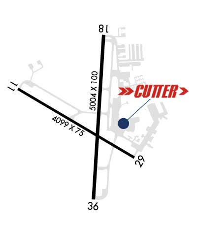 Airport Diagram might not be current. | |
| Facility Name: | GEORGETOWN EXEC |
| City Name: | GEORGETOWN |
| County: | WILLIAMSON |
| State abbrev: | TX |
| State Name: | TEXAS |
| Ownership: | PUBLICLY OWNED |
| Use: | OPEN TO THE PUBLIC |
| Owner's Name: | CITY OF GEORGETOWN |
| Address: | PO BOX 409 |
| GEORGETOWN, TX 78627 | |
| Owner's Phone: | (512) 930-3666 |
| Manager's Name: | MATTHEW SOMMERFELD |
| Address: | 500 TERMINAL DRIVE |
| GEORGETOWN, TX 78628 | |
| Phone: | 512-930-8464; EMERG 512-930-8464. |
| FAA Region: | SOUTHWEST |
| FAA Field Office: | TEX |
| Date | Sunrise | Sunset |
|---|---|---|
| 02/03/25 Monday | 7:21 | 18:09 |
| 02/04/25 Tuesday | 7:20 | 18:09 |
| 02/05/25 Wednesday | 7:20 | 18:10 |
| 02/06/25 Thursday | 7:19 | 18:11 |
| 02/07/25 Friday | 7:18 | 18:12 |
| 02/08/25 Saturday | 7:17 | 18:13 |
| 02/09/25 Sunday | 7:17 | 18:14 |
| 02/10/25 Monday | 7:16 | 18:15 |
| 02/11/25 Tuesday | 7:15 | 18:15 |
| 02/12/25 Wednesday | 7:14 | 18:16 |
| 02/13/25 Thursday | 7:13 | 18:17 |
| 02/14/25 Friday | 7:13 | 18:18 |
| 02/15/25 Saturday | 7:12 | 18:19 |
| 02/16/25 Sunday | 7:11 | 18:19 |
| Airport Attendance Schedule | 7 Days A Week 0700-1900 |
| Airport Status | OPERATIONAL (This Status can change at any time - please check NOTAMS) |
| Airport Lighting Schedule | AFTR TWR HRS, MIRL RWY 18/36 PRESET LOW INTST; TO INCR INTST & ACTVT REILS RWY 18/36 & MIRL RWY 11/29 - CTAF. PAPI RWY 18 & 36 OPS CONSLY. |
| Airport Storage Available | Tie Downs, Hanger |
| Extra Services Available | Air Ambulance, Avionics, Flight Instruction, Aircraft Rental, Aircraft Sales |
| Wind Indicator | YES - (lighted) |
| Control Tower | YES |
| CTAF Frequency | 120.225 |
| Unicom Frequency | 123.000 |
| Rotating Beacon Color | WG |
| Segmented Circle | YES |
| Landing Fee | NO |
| Airport Inspected | STATE - performed by PRIVATE CONTRACT PERSONNEL |
| Inspection Date | 06/06/2023 |
| Type of Fuel Available | Grade 100LL, JET A-1 (icing inhibitor, freeze point -50C) |
| Airframe Repair Service | MAJOR |
| Power Plant Repair Service | MAJOR |
| Latitude | N3040.7 |
| Longitude | W09740.8 (ESTIMATED) |
| Arpt Elevation | 789ft (SURVEYED) |
| Magnetic Variation | 06E |
| 3 miles N | of GEORGETOWN |
| Traffic Pattern Altitude | |
| Sectional Chart | SAN ANTONIO |
| Operations (Reported) | Yearly | Avg. Daily |
|---|---|---|
| General Aviation Transient | 0 | 0 |
| General Aviation Local | 0 | 0 |
| Air Taxi | 0 | 0 |
| Commerical | 0 | 0 |
| Commuter | 0 | 0 |
| Military | 0 | 0 |
| Aircraft based on Field | |
|---|---|
| General Aviation Singles | 0 |
| General Aviation Multi | 0 |
| Jet Aircraft | 0 |
| General Aviation Helicopters | 0 |
| Military Aircraft | 0 |
| Gliders | 0 |
| Ultralights | 0 |
| FSS on field | NO |
| FSS tie-in | SAN ANGELO |
| FSS Phone | 1-800-WX-BRIEF |
| Who issues Notams | GTU |
| Notam D service at airport | YES |
| ARTCC Name | HOUSTON |
| Airport Certification | |
| Aircraft Rescue & Firefighting Index | None |
| Airport of Entry | No |
| Custom Landing Rights | No |
| Joint Civil/Military | No |
| Military Landing rights | No |
| NATIONAL PLAN OF INTEGRATED AIRPORT SYSTEMS (NPIAS) |
| GRANT AGREEMENTS UNDER FAAP/ADAP/AIP |
| ASSURANCES PURSUANT TO TITLE VI, CIVIL RIGHTS ACT OF 1964 |
| AGREEMENT UNDER DLAND OR DCLA HAS EXPIRED. |
| DEER ON & INVOF ARPT. |
| MIL HEL OPNS PROHIBITED BTN 2100-0700. |
| PTN OF TWY F NOT VISIBLE FM TWR. |
| FOR CD CTC AUSTIN APCH AT 512-369-7865. |
| RWY 18/36 CLSD TO HEL SKID LDG TO PREVENT DMG TO GROOVED SFC. |
Airport Communications & Frequencies:
| ||||||||||||||||||||||||
| Runway: 11 | Runway: 29 | ||
| Mag heading: | 115° | Mag heading: | 295° |
| Rwy Slope: | -.75% Down | Rwy Slope: | .75% Up |
| Approach: | Approach: | ||
| Pattern: | Left Traffic | Pattern: | Right Traffic |
| Markings: | NONPRECISION INSTRUMENT | Markings: | NONPRECISION INSTRUMENT |
| Marking Condition: | GOOD | Marking Condition: | GOOD |
| Arresting Dev: | Arresting Dev: | ||
| Lat & Long: | N3040.9 W09741.2 | Lat. & Long.: | N3040.5 W09740.5 |
| Elev: | 789.4 ft. MSL | Elev: | 758.7 ft. MSL |
| TCH: | TCH: | ||
| Visual Glide Path: | Visual Glide Path: | ||
| Displaced Threshold: | No | Displaced Threshold: | No |
| Touchdown Zone: | YES | Touchdown Zone: | YES |
| Touchdown Elev.: | 789.5 feet | Touchdown Elev.: | 777.3 feet |
| Visual Glide Slope: | Visual Glide Slope: | ||
| RVR Equipment: | RVR Equipment: | ||
| RVV Equipment: | NO | RVV Equipment: | NO |
| Approach Lights: | Approach Lights: | ||
| REIL: | NO | REIL: | NO |
| Centerline Lights: | NO | Centerline Lights: | NO |
| Touchdown lights: | NO | Touchdown lights: | NO |
| Runway Category: | Runway with a Non-precision Approach | Runway Category: | Runway with a Non-precision Approach |
| Declared Distances: | Declared Distances: | ||
| Obstructions: | TREE | Obstructions: | TREE |
| Marked: | NOT Marked/Lighted | Marked: | NOT Marked/Lighted |
| Clearance slope: | 29:1 | Clearance slope: | |
| Obstruction height: | 42 feet AGL | Obstruction height: | 30 feet AGL |
| Dist. from runway: | 1425 feet | Dist. from runway: | 210 feet |
| Centerline offset: | 212 left of centerline | Centerline offset: | 214 feet left of centerline |
| Comments: | Comments: | 8 FT FENCE 199 FT DSTC, 246 FT L. |
| Runway: 18 | Runway: 36 | ||
| Mag heading: | 178° | Mag heading: | 358° |
| Rwy Slope: | -.76% Down | Rwy Slope: | .76% Up |
| Approach: | Approach: | ||
| Pattern: | Left Traffic | Pattern: | Right Traffic |
| Markings: | NONPRECISION INSTRUMENT | Markings: | NONPRECISION INSTRUMENT |
| Marking Condition: | GOOD | Marking Condition: | GOOD |
| Arresting Dev: | Arresting Dev: | ||
| Lat & Long: | N3041.2 W09740.7 | Lat. & Long.: | N3040.3 W09740.7 |
| Elev: | 785.7 ft. MSL | Elev: | 747.5 ft. MSL |
| TCH: | 35 ft. AGL | TCH: | 50 ft. AGL |
| Visual Glide Path: | 3.00 degrees | Visual Glide Path: | 3.00 degrees |
| Displaced Threshold: | No | Displaced Threshold: | No |
| Touchdown Zone: | YES | Touchdown Zone: | YES |
| Touchdown Elev.: | 785.7 feet | Touchdown Elev.: | 764.5 feet |
| Visual Glide Slope: | 4-Light PAPI on LEFT side of Runway | Visual Glide Slope: | 4-Light PAPI on LEFT side of Runway |
| RVR Equipment: | RVR Equipment: | ||
| RVV Equipment: | NO | RVV Equipment: | NO |
| Approach Lights: | Approach Lights: | ||
| REIL: | YES | REIL: | YES |
| Centerline Lights: | NO | Centerline Lights: | NO |
| Touchdown lights: | NO | Touchdown lights: | NO |
| Runway Category: | Runway with a Non-precision Approach having visibility minimums greater than 3/4 mile | Runway Category: | Runway with a Non-precision Approach having visibility minimums greater than 3/4 mile |
| Declared Distances: | Declared Distances: | ||
| Obstructions: | TREES | Obstructions: | TREES |
| Marked: | NOT Marked/Lighted | Marked: | NOT Marked/Lighted |
| Clearance slope: | 30:1 | Clearance slope: | 28:1 |
| Obstruction height: | 37 feet AGL | Obstruction height: | 34 feet AGL |
| Dist. from runway: | 1320 feet | Dist. from runway: | 1170 feet |
| Centerline offset: | 69 right of centerline | Centerline offset: | 30 feet right of centerline |
| Comments: | Comments: |
Thanks for using FltPlan.com
all rights reserved © 1999-2025 by Flight Plan LLC


