| NORTH PERRY HOLLYWOOD FL |
| |
| Lat: N 2600.1 Long: W 08014.4 Elev: 9 Var: +06 Longest Runway: 3463 | ||
| Dept. ATIS: 135.47 Arr. ATIS: 135.47 Ground: 120.45 Tower: 132.1/134.3 | ||

| ||||||||||||||||||||||||||||||||||||||||||||||||||||||||||||||||||||
| ||||||||||||||||||||||||||||||||||||||||||||||||||||||||||||||||||||
| ||||||||||||||||||||||||||||||||||||||||||||||||||||||||||||||||||||
| ||||||||||||||||||||||||||||||||||||||||||||||||||||||||||||||||||||
| ||||||||||||||||||||||||||||||||||||||||||||||||||||||||||||||||||||
| ||||||||||||||||||||||||||||||||||||||||||||||||||||||||||||||||||||
| Rwy | Rwy | |||||||
| 3000x100 | 3000' | 3000x100 | 2650' | |||||
| 3260x100 | 3075' | 3260x100 | 3149' | |||||
| 3241x100 | 3060' | 3241x100 | 3180' | |||||
| 3463x100 | 2999' | 3463x100 | 3253' | |||||
| Runway ID | Single Wheel | Double Wheel | Double Tandem Wheel | Dual Double Wheel |
| 01L/19R | 85,000 | 131,000 | N/A | N/A |
| 01R/19L | 29,500 | 45,000 | N/A | N/A |
| 10L/28R | 24,000 | 38,500 | N/A | N/A |
| 10R/28L | 85,000 | 131,000 | N/A | N/A |
| These numbers are Advisory and are not limits. The Airport Manager should have more accurate Weight Limits | ||||
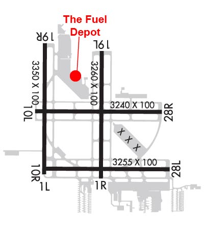 Airport Diagram might not be current. | |
| Facility Name: | NORTH PERRY |
| City Name: | HOLLYWOOD |
| County: | BROWARD |
| State abbrev: | FL |
| State Name: | FLORIDA |
| Ownership: | PUBLICLY OWNED |
| Use: | OPEN TO THE PUBLIC |
| Owner's Name: | BROWARD COUNTY; CONTACT PERSON: MARK GALE A.A.E. 954-359-6100 |
| Address: | 320 TERMINAL DR SUITE 200 |
| FT LAUDERDALE, FL 33315 | |
| Owner's Phone: | 954-359-6100 |
| Manager's Name: | NINA MACPHERSON |
| Address: | 101 SOUTHWEST 77TH WAY |
| PEMBROKE PINES, FL 33023 | |
| Phone: | 954-359-1016 |
| FAA Region: | SOUTHERN |
| FAA Field Office: | ORL |
| Date | Sunrise | Sunset |
|---|---|---|
| 04/16/25 Wednesday | 6:57 | 19:45 |
| 04/17/25 Thursday | 6:56 | 19:45 |
| 04/18/25 Friday | 6:55 | 19:46 |
| 04/19/25 Saturday | 6:54 | 19:46 |
| 04/20/25 Sunday | 6:53 | 19:47 |
| 04/21/25 Monday | 6:52 | 19:47 |
| 04/22/25 Tuesday | 6:52 | 19:48 |
| 04/23/25 Wednesday | 6:51 | 19:48 |
| 04/24/25 Thursday | 6:50 | 19:49 |
| 04/25/25 Friday | 6:49 | 19:49 |
| 04/26/25 Saturday | 6:48 | 19:50 |
| 04/27/25 Sunday | 6:47 | 19:50 |
| 04/28/25 Monday | 6:46 | 19:51 |
| 04/29/25 Tuesday | 6:46 | 19:51 |
| Airport Attendance Schedule | 7 Days A Week 0700-2100 |
| Airport Status | OPERATIONAL (This Status can change at any time - please check NOTAMS) |
| Airport Lighting Schedule | ATC-CTL. WHEN ATCT CLSD ACTVT MIRL RWY 10R/28L, 01L/19R - CTAF. |
| Airport Storage Available | Tie Downs, Hanger |
| Extra Services Available | Avionics, Charter, Flight Instruction, Aircraft Rental, Aircraft Sales |
| Wind Indicator | YES - (lighted) |
| Control Tower | YES |
| CTAF Frequency | 132.100 |
| Unicom Frequency | 122.950 |
| Rotating Beacon Color | WG |
| Segmented Circle | Y-L |
| Landing Fee | NO |
| Airport Inspected | STATE - performed by STATE AERONAUTICAL PERSONNEL |
| Inspection Date | 05/15/2024 |
| Type of Fuel Available | Grade 100LL, JET A (freeze point -40C) |
| Airframe Repair Service | MAJOR |
| Power Plant Repair Service | MAJOR |
| Latitude | N2600.1 |
| Longitude | W08014.4 (ESTIMATED) |
| Arpt Elevation | 8ft (SURVEYED) |
| Magnetic Variation | 06W |
| 5 miles W | of HOLLYWOOD |
| Traffic Pattern Altitude | 800 |
| Sectional Chart | MIAMI |
| Operations (Reported) | Yearly | Avg. Daily |
|---|---|---|
| General Aviation Transient | 0 | 0 |
| General Aviation Local | 0 | 0 |
| Air Taxi | 0 | 0 |
| Commerical | 0 | 0 |
| Commuter | 0 | 0 |
| Military | 0 | 0 |
| Aircraft based on Field | |
|---|---|
| General Aviation Singles | 0 |
| General Aviation Multi | 0 |
| Jet Aircraft | 0 |
| General Aviation Helicopters | 0 |
| Military Aircraft | 0 |
| Gliders | 0 |
| Ultralights | 0 |
| FSS on field | NO |
| FSS tie-in | MIAMI |
| FSS Phone | 1-800-WX-BRIEF |
| Who issues Notams | HWO |
| Notam D service at airport | YES |
| ARTCC Name | MIAMI |
| Airport Certification | |
| Aircraft Rescue & Firefighting Index | None |
| Airport of Entry | No |
| Custom Landing Rights | No |
| Joint Civil/Military | No |
| Military Landing rights | YES |
| NATIONAL PLAN OF INTEGRATED AIRPORT SYSTEMS (NPIAS) |
| GRANT AGREEMENTS UNDER FAAP/ADAP/AIP |
| SURPLUS PROPERTY AGREEMENT UNDER PUBLIC LAW 289 |
| ASSURANCES PURSUANT TO TITLE VI, CIVIL RIGHTS ACT OF 1964 |
| ARPT CLSD TO ACFT OVER 12500 LBS MAX CERTD TOG. |
| NUMEROUS TALL TOWERS SE OF ARPT CAUSE RADIO INTFC. |
| HIGH VOL OF BANNER TOWING AND STUDENT FLT INVOF ARPT. |
| BIRD ACTIVITY ON & INVOF AIRPORT. |
| RWY CONDITION NOT MONITORED WHEN TOWER CLOSED. |
Airport Communications & Frequencies:
| |||||||||||||||||||||||||||||
| Runway: 01L | Runway: 19R | ||
| Mag heading: | 6° | Mag heading: | 186° |
| Rwy Slope: | .00% | Rwy Slope: | .00% |
| Approach: | Approach: | ||
| Pattern: | Left Traffic | Pattern: | Right Traffic |
| Markings: | BASIC | Markings: | BASIC |
| Marking Condition: | GOOD | Marking Condition: | GOOD |
| Arresting Dev: | Arresting Dev: | ||
| Lat & Long: | N2559.9 W08014.6 | Lat. & Long.: | N2600.4 W08014.6 |
| Elev: | 7.2 ft. MSL | Elev: | 7.2 ft. MSL |
| TCH: | 40 ft. AGL | TCH: | 24 ft. AGL |
| Visual Glide Path: | 3.50 degrees | Visual Glide Path: | 3.50 degrees |
| Displaced Threshold: | No | Displaced Threshold: | 350 feet |
| Touchdown Zone: | YES | Touchdown Zone: | YES |
| Touchdown Elev.: | 7.6 feet | Touchdown Elev.: | 7.6 feet |
| Visual Glide Slope: | 2-Light PAPI on LEFT side of Runway | Visual Glide Slope: | 2-Light PAPI on LEFT side of Runway |
| RVR Equipment: | RVR Equipment: | ||
| RVV Equipment: | NO | RVV Equipment: | NO |
| Approach Lights: | Approach Lights: | ||
| REIL: | YES | REIL: | YES |
| Centerline Lights: | NO | Centerline Lights: | NO |
| Touchdown lights: | NO | Touchdown lights: | NO |
| Runway Category: | Runway with a Visual Approach | Runway Category: | Runway with a Visual Approach |
| Declared Distances: | Declared Distances: | ||
| Obstructions: | TREE | Obstructions: | TREE |
| Marked: | NOT Marked/Lighted | Marked: | NOT Marked/Lighted |
| Clearance slope: | 21:1 | Clearance slope: | 19:1; RWY 19R APCH SLOPE 33:1 TO THE DSPLCD THR. |
| Obstruction height: | 45 feet AGL | Obstruction height: | 40 feet AGL |
| Dist. from runway: | 1170 feet | Dist. from runway: | 990 feet |
| Centerline offset: | 85 left of centerline | Centerline offset: | 160 feet left of centerline |
| Comments: | Comments: |
| Runway: 01R | Runway: 19L | ||
| Mag heading: | 6° | Mag heading: | 186° |
| Rwy Slope: | -.02% Down | Rwy Slope: | .02% Up |
| Approach: | Approach: | ||
| Pattern: | Right Traffic | Pattern: | Left Traffic |
| Markings: | BASIC | Markings: | BASIC |
| Marking Condition: | GOOD | Marking Condition: | GOOD |
| Arresting Dev: | Arresting Dev: | ||
| Lat & Long: | N2559.9 W08014.4 | Lat. & Long.: | N2600.4 W08014.4 |
| Elev: | 7.3 ft. MSL | Elev: | 6.8 ft. MSL |
| TCH: | 40 ft. AGL | TCH: | 33 ft. AGL |
| Visual Glide Path: | 3.50 degrees | Visual Glide Path: | 3.50 degrees |
| Displaced Threshold: | 185 feet | Displaced Threshold: | 111 feet |
| Touchdown Zone: | YES | Touchdown Zone: | YES |
| Touchdown Elev.: | 8.5 feet | Touchdown Elev.: | 8.5 feet |
| Visual Glide Slope: | 2-Light PAPI on LEFT side of Runway | Visual Glide Slope: | 2-Light PAPI on LEFT side of Runway |
| RVR Equipment: | RVR Equipment: | ||
| RVV Equipment: | NO | RVV Equipment: | NO |
| Approach Lights: | Approach Lights: | ||
| REIL: | NO | REIL: | NO |
| Centerline Lights: | NO | Centerline Lights: | NO |
| Touchdown lights: | NO | Touchdown lights: | NO |
| Runway Category: | Runway with a Visual Approach | Runway Category: | Runway with a Visual Approach |
| Declared Distances: | Declared Distances: | ||
| Obstructions: | TREES | Obstructions: | TREE |
| Marked: | NOT Marked/Lighted | Marked: | NOT Marked/Lighted |
| Clearance slope: | 17:1; RWY 01R APCH SLOPE 25:1 TO THE DSPLCD THR. | Clearance slope: | 21:1 |
| Obstruction height: | 50 feet AGL | Obstruction height: | 54 feet AGL |
| Dist. from runway: | 1060 feet | Dist. from runway: | 1380 feet |
| Centerline offset: | 140 right of centerline | Centerline offset: | 125 feet left of centerline |
| Comments: | Comments: |
| Runway: 10L | Runway: 28R | ||
| Mag heading: | 96° | Mag heading: | 276° |
| Rwy Slope: | .02% Up | Rwy Slope: | -.02% Down |
| Approach: | Approach: | ||
| Pattern: | Left Traffic | Pattern: | Right Traffic |
| Markings: | BASIC | Markings: | NONPRECISION INSTRUMENT |
| Marking Condition: | GOOD | Marking Condition: | GOOD |
| Arresting Dev: | Arresting Dev: | ||
| Lat & Long: | N2600.1 W08014.7 | Lat. & Long.: | N2600.1 W08014.1 |
| Elev: | 6.9 ft. MSL | Elev: | 7.5 ft. MSL |
| TCH: | 40 ft. AGL | TCH: | 39 ft. AGL |
| Visual Glide Path: | 3.50 degrees | Visual Glide Path: | 3.50 degrees |
| Displaced Threshold: | 181 feet | Displaced Threshold: | 61 feet |
| Touchdown Zone: | YES | Touchdown Zone: | YES |
| Touchdown Elev.: | 8.5 feet | Touchdown Elev.: | 8.5 feet |
| Visual Glide Slope: | 2-Light PAPI on LEFT side of Runway | Visual Glide Slope: | 2-Light PAPI on LEFT side of Runway |
| RVR Equipment: | RVR Equipment: | ||
| RVV Equipment: | NO | RVV Equipment: | NO |
| Approach Lights: | Approach Lights: | ||
| REIL: | NO | REIL: | NO |
| Centerline Lights: | NO | Centerline Lights: | NO |
| Touchdown lights: | NO | Touchdown lights: | NO |
| Runway Category: | Runway with a Visual Approach | Runway Category: | Runway with a Non-precision Approach |
| Declared Distances: | Declared Distances: | ||
| Obstructions: | TREE | Obstructions: | TREES |
| Marked: | NOT Marked/Lighted | Marked: | NOT Marked/Lighted |
| Clearance slope: | 17:1; RWY 10L APCH SLOPE 25:1 TO THE DSPLCD THR. | Clearance slope: | 23:1; RWY 28R APCH SLOPE 31:1 TO THE DSPLCD THR. |
| Obstruction height: | 64 feet AGL | Obstruction height: | 42 feet AGL |
| Dist. from runway: | 1340 feet | Dist. from runway: | 1145 feet |
| Centerline offset: | 165 left of centerline | Centerline offset: | 75 feet right of centerline |
| Comments: | Comments: |
| Runway: 10R | Runway: 28L | ||
| Mag heading: | 96° | Mag heading: | 276° |
| Rwy Slope: | .02% Up | Rwy Slope: | -.02% Down |
| Approach: | Approach: | ||
| Pattern: | Right Traffic | Pattern: | Left Traffic |
| Markings: | NONPRECISION INSTRUMENT | Markings: | BASIC |
| Marking Condition: | GOOD | Marking Condition: | GOOD |
| Arresting Dev: | Arresting Dev: | ||
| Lat & Long: | N2559.9 W08014.7 | Lat. & Long.: | N2559.9 W08014.1 |
| Elev: | 7.2 ft. MSL | Elev: | 7.8 ft. MSL |
| TCH: | 45 ft. AGL | TCH: | 24 ft. AGL |
| Visual Glide Path: | 3.50 degrees | Visual Glide Path: | 3.50 degrees |
| Displaced Threshold: | 464 feet | Displaced Threshold: | 210 feet |
| Touchdown Zone: | YES | Touchdown Zone: | YES |
| Touchdown Elev.: | 8.2 feet | Touchdown Elev.: | 8.2 feet |
| Visual Glide Slope: | 4-Light PAPI on LEFT side of Runway | Visual Glide Slope: | 2-Light PAPI on LEFT side of Runway |
| RVR Equipment: | RVR Equipment: | ||
| RVV Equipment: | NO | RVV Equipment: | NO |
| Approach Lights: | Approach Lights: | ||
| REIL: | YES | REIL: | YES |
| Centerline Lights: | NO | Centerline Lights: | NO |
| Touchdown lights: | NO | Touchdown lights: | NO |
| Runway Category: | Runway with a Non-precision Approach | Runway Category: | Runway with a Visual Approach |
| Declared Distances: | TORA:3463' TODA:3463' ASDA:3463' LDA:2999' | Declared Distances: | TORA:3463' TODA:3463' ASDA:3463' LDA:3253' |
| Obstructions: | BLDG | Obstructions: | TREE |
| Marked: | LIGHTED | Marked: | NOT Marked/Lighted |
| Clearance slope: | 24:1; RY 10R APCH SLOPE 32:1 TO THE DSPLCD THLD. | Clearance slope: | 17:1; RWY 28L APCH SLOPE 26:1 TO THE DSPLCD THR. |
| Obstruction height: | 59 feet AGL | Obstruction height: | 47 feet AGL |
| Dist. from runway: | 1618 feet | Dist. from runway: | 1005 feet |
| Centerline offset: | 35 right of centerline | Centerline offset: | 215 feet left of centerline |
| Comments: | Comments: |
Thanks for using FltPlan.com
all rights reserved © 1999-2025 by Flight Plan LLC