| JEFFERSON CITY MEMORIAL JEFFERSON CITY MO |
| |
| Lat: N 3835.5 Long: W 09209.4 Elev: 549 Var: +01 Longest Runway: 6000 | ||
| AWOS: 133.62 Ground: 121.7 Tower: 125.6 | ||
| ||||||||||||||||||||||||||||||||||||||||||||||||||||||||||||||||||||
| ||||||||||||||||||||||||||||||||||||||||||||||||||||||||||||||||||||
| ||||||||||||||||||||||||||||||||||||||||||||||||||||||||||||||||||||
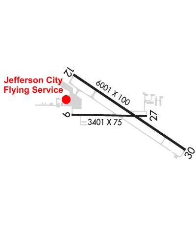
| Rwy | Rwy | |||||||
| 3401x75 | 3401' | 3401x75 | 3401' | |||||
| 6000x100 | 6000' | 6000x100 | 6000' | 110.50 - 299° | ||||
| Runway ID | Single Wheel | Double Wheel | Double Tandem Wheel | Dual Double Wheel |
| 09/27 | 33,500 | 44,000 | N/A | N/A |
| 12/30 | 85,000 | 104,000 | 168,000 | N/A |
| These numbers are Advisory and are not limits. The Airport Manager should have more accurate Weight Limits | ||||
 Airport Diagram might not be current. | |
| Facility Name: | JEFFERSON CITY MEML |
| City Name: | JEFFERSON CITY |
| County: | CALLAWAY |
| State abbrev: | MO |
| State Name: | MISSOURI |
| Ownership: | PUBLICLY OWNED |
| Use: | OPEN TO THE PUBLIC |
| Owner's Name: | CITY OF JEFFERSON |
| Address: | 320 E. MCCARTY ST. |
| JEFFERSON CITY, MO 65101 | |
| Owner's Phone: | 573-634-6469 |
| Manager's Name: | ERIC BOWERS |
| Address: | 320 E. MCCARTY ST. |
| JEFFERSON CITY, MO 65101 | |
| Phone: | 573-634-6469 |
| FAA Region: | CENTRAL |
| FAA Field Office: | NONE |
| Date | Sunrise | Sunset |
|---|---|---|
| 02/10/25 Monday | 7:06 | 17:41 |
| 02/11/25 Tuesday | 7:04 | 17:42 |
| 02/12/25 Wednesday | 7:03 | 17:43 |
| 02/13/25 Thursday | 7:02 | 17:44 |
| 02/14/25 Friday | 7:01 | 17:45 |
| 02/15/25 Saturday | 7:00 | 17:46 |
| 02/16/25 Sunday | 6:59 | 17:48 |
| 02/17/25 Monday | 6:57 | 17:49 |
| 02/18/25 Tuesday | 6:56 | 17:50 |
| 02/19/25 Wednesday | 6:55 | 17:51 |
| 02/20/25 Thursday | 6:54 | 17:52 |
| 02/21/25 Friday | 6:52 | 17:53 |
| 02/22/25 Saturday | 6:51 | 17:54 |
| 02/23/25 Sunday | 6:50 | 17:55 |
| Airport Attendance Schedule | 7 Days A Week 0630-2030 |
| Airport Status | OPERATIONAL (This Status can change at any time - please check NOTAMS) |
| Airport Lighting Schedule | WHEN ATCT CLSD ACTVT MALSR RWY 30; REIL RWYS 9, 12, 27; HIRL RWY 12/30; & TWY A LGTS - CTAF. VASI RWYS 12 & 30 OPR CONSLY. |
| Airport Storage Available | Tie Downs, Hanger |
| Extra Services Available | Air Freight, Charter, Flight Instruction, Aircraft Rental, Aircraft Sales |
| Wind Indicator | YES - (lighted) |
| Control Tower | YES |
| CTAF Frequency | 125.600 |
| Unicom Frequency | 122.950 |
| Rotating Beacon Color | WG |
| Segmented Circle | NO |
| Landing Fee | NO |
| Airport Inspected | FEDERAL - performed by STATE AERONAUTICAL PERSONNEL |
| Inspection Date | 09/28/2023 |
| Type of Fuel Available | Grade 100LL, JET A (freeze point -40C); -10AVBL FROM 0630 - 2030 Z++. |
| Airframe Repair Service | MAJOR |
| Power Plant Repair Service | MAJOR |
| Latitude | N3835.5 |
| Longitude | W09209.4 (ESTIMATED) |
| Arpt Elevation | 549ft (SURVEYED) |
| Magnetic Variation | 01W |
| 2 miles NE | of JEFFERSON CITY |
| Traffic Pattern Altitude | |
| Sectional Chart | KANSAS CITY |
| Operations (Reported) | Yearly | Avg. Daily |
|---|---|---|
| General Aviation Transient | 0 | 0 |
| General Aviation Local | 0 | 0 |
| Air Taxi | 0 | 0 |
| Commerical | 0 | 0 |
| Commuter | 0 | 0 |
| Military | 0 | 0 |
| Aircraft based on Field | |
|---|---|
| General Aviation Singles | 0 |
| General Aviation Multi | 0 |
| Jet Aircraft | 0 |
| General Aviation Helicopters | 0 |
| Military Aircraft | 0 |
| Gliders | 0 |
| Ultralights | 0 |
| FSS on field | NO |
| FSS tie-in | COLUMBIA |
| FSS Phone | 1-800-WX-BRIEF |
| Who issues Notams | JEF |
| Notam D service at airport | YES |
| ARTCC Name | KANSAS CITY |
| Airport Certification | |
| Aircraft Rescue & Firefighting Index | ARFF AVBL WITH PPR 24 HOURS 573-634-6469. |
| Airport of Entry | No |
| Custom Landing Rights | No |
| Joint Civil/Military | No |
| Military Landing rights | YES |
| NATIONAL PLAN OF INTEGRATED AIRPORT SYSTEMS (NPIAS) |
| GRANT AGREEMENTS UNDER FAAP/ADAP/AIP |
| ASSURANCES PURSUANT TO TITLE VI, CIVIL RIGHTS ACT OF 1964 |
| LIGHT TO MODERATE BIRD ACTVTY INVOF ARPT. |
| ENTRANCES TO E & S HANGARS, NOT VISIBLE BY TWR. |
| ARFF AVBL WITH PPR 24 HOURS 573-634-6469. |
| FOR CD CTC MIZZOU APCH AT 417-868-5620/5619. |
Airport Communications & Frequencies:
| ||||||||||||||||||||
| Runway: 09 | Runway: 27 | ||
| Mag heading: | 92° | Mag heading: | 272° |
| Rwy Slope: | -.01% Down | Rwy Slope: | .01% Up |
| Approach: | Approach: | ||
| Pattern: | Left Traffic | Pattern: | Left Traffic |
| Markings: | BASIC | Markings: | BASIC |
| Marking Condition: | GOOD | Marking Condition: | GOOD |
| Arresting Dev: | Arresting Dev: | ||
| Lat & Long: | N3835.5 W09209.8 | Lat. & Long.: | N3835.5 W09209.1 |
| Elev: | 546.3 ft. MSL | Elev: | 545.9 ft. MSL |
| TCH: | 23 ft. AGL | TCH: | 29 ft. AGL |
| Visual Glide Path: | 3.00 degrees | Visual Glide Path: | 3.00 degrees |
| Displaced Threshold: | No | Displaced Threshold: | No |
| Touchdown Zone: | YES | Touchdown Zone: | YES |
| Touchdown Elev.: | 547.5 feet | Touchdown Elev.: | 547.5 feet |
| Visual Glide Slope: | 4-Light PAPI on LEFT side of Runway | Visual Glide Slope: | 4-Light PAPI on LEFT side of Runway |
| RVR Equipment: | RVR Equipment: | ||
| RVV Equipment: | NO | RVV Equipment: | NO |
| Approach Lights: | Approach Lights: | ||
| REIL: | YES | REIL: | YES |
| Centerline Lights: | NO | Centerline Lights: | NO |
| Touchdown lights: | NO | Touchdown lights: | NO |
| Runway Category: | Runway with a Visual Approach | Runway Category: | Runway with a Visual Approach |
| Declared Distances: | Declared Distances: | ||
| Obstructions: | HANGAR | Obstructions: | TREES |
| Marked: | NOT Marked/Lighted | Marked: | NOT Marked/Lighted |
| Clearance slope: | 17:1 | Clearance slope: | 17:1 |
| Obstruction height: | 23 feet AGL | Obstruction height: | 53 feet AGL |
| Dist. from runway: | 600 feet | Dist. from runway: | 1127 feet |
| Centerline offset: | 230 left of centerline | Centerline offset: | 75B |
| Comments: | Comments: |
| Runway: 12 | Runway: 30 | ||
| Mag heading: | 124° | Mag heading: | 304° |
| Rwy Slope: | .00% Up | Rwy Slope: | .00% Down |
| Approach: | Approach: | ILS/DME | |
| Pattern: | Left Traffic | Pattern: | Left Traffic |
| Markings: | PRECISION INSTRUMENT | Markings: | PRECISION INSTRUMENT |
| Marking Condition: | GOOD | Marking Condition: | GOOD |
| Arresting Dev: | Arresting Dev: | ||
| Lat & Long: | N3835.7 W09209.8 | Lat. & Long.: | N3835.2 W09208.8 |
| Elev: | 547.2 ft. MSL | Elev: | 547.3 ft. MSL |
| TCH: | 64 ft. AGL | TCH: | 50 ft. AGL |
| Visual Glide Path: | 3.50 degrees | Visual Glide Path: | 3.00 degrees |
| Displaced Threshold: | No | Displaced Threshold: | No |
| Touchdown Zone: | YES | Touchdown Zone: | YES |
| Touchdown Elev.: | 547.5 feet | Touchdown Elev.: | 549.4 feet |
| Visual Glide Slope: | 4-BOX VASI ON LEFT SIDE OF RUNWAY | Visual Glide Slope: | 4-BOX VASI ON LEFT SIDE OF RUNWAY |
| RVR Equipment: | RVR Equipment: | ||
| RVV Equipment: | NO | RVV Equipment: | NO |
| Approach Lights: | Approach Lights: | MALSR - 1,400 foot medium intensity approach lighting system with runway alignment indicator lights | |
| REIL: | YES | REIL: | NO |
| Centerline Lights: | NO | Centerline Lights: | NO |
| Touchdown lights: | NO | Touchdown lights: | NO |
| Runway Category: | Runway with a Non-precision Approach having visibility minimums greater than 3/4 mile | Runway Category: | Precision Instrument Runway |
| Declared Distances: | Declared Distances: |
Thanks for using FltPlan.com
all rights reserved © 1999-2025 by Flight Plan LLC