
| JACK EDWARDS GULF SHORES AL |
| |
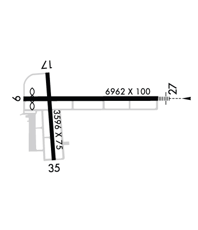
| Lat: N 3017.4 Long: W 08740.3 Elev: 17 Var: -00 Longest Runway: 6962 | ||
| Clr Del: 124.55 Dept. ATIS: 134.52 Arr. ATIS: 134.52 AWOS: 134.52 Ground: 121.7 Tower: 118.65 | ||
| ||||||||||||||||||||||||||||||||||||||||||||
| ||||||||||||||||||||||||||||||||||||||||||||
| ||||||||||||||||||||||||||||||||||||||||||||
| Rwy | Rwy | |||||||
| 6962x100 | 6500' | 6962x100 | 6962' | 110.70 - 269° | ||||
| 3596x75 | 3596' | 3596x75 | 3276' | |||||
| Runway ID | Single Wheel | Double Wheel | Double Tandem Wheel | Dual Double Wheel |
| 09/27 | 80,000 | 100,000 | N/A | N/A |
| 17/35 | 80,000 | 100,000 | N/A | N/A |
| These numbers are Advisory and are not limits. The Airport Manager should have more accurate Weight Limits | ||||
 Airport Diagram might not be current. | |
| Facility Name: | GULF SHORES INTL/JACK EDWARDS FLD |
| City Name: | GULF SHORES |
| County: | BALDWIN |
| State abbrev: | AL |
| State Name: | ALABAMA |
| Ownership: | PUBLICLY OWNED |
| Use: | OPEN TO THE PUBLIC |
| Owner's Name: | GULF SHORES AIRPORT AUTHORITY |
| Address: | PO BOX 919 |
| GULF SHORES, AL 36547 | |
| Owner's Phone: | 251-967-3968 |
| Manager's Name: | JESSE FOSNAUGH |
| Address: | PO BOX 919 |
| GULF SHORES, AL 36547 | |
| Phone: | 251-967-3968 |
| FAA Region: | SOUTHERN |
| FAA Field Office: | JAN |
| Date | Sunrise | Sunset |
|---|---|---|
| 03/13/25 Thursday | 7:03 | 18:58 |
| 03/14/25 Friday | 7:02 | 18:58 |
| 03/15/25 Saturday | 7:01 | 18:59 |
| 03/16/25 Sunday | 7:00 | 19:00 |
| 03/17/25 Monday | 6:59 | 19:00 |
| 03/18/25 Tuesday | 6:57 | 19:01 |
| 03/19/25 Wednesday | 6:56 | 19:01 |
| 03/20/25 Thursday | 6:55 | 19:02 |
| 03/21/25 Friday | 6:54 | 19:03 |
| 03/22/25 Saturday | 6:52 | 19:03 |
| 03/23/25 Sunday | 6:51 | 19:04 |
| 03/24/25 Monday | 6:50 | 19:05 |
| 03/25/25 Tuesday | 6:49 | 19:05 |
| 03/26/25 Wednesday | 6:48 | 19:06 |
| Airport Attendance Schedule | 7 Days A Week 0600-2200; AFT HRS SVC CALL (251) 968-5200. |
| Airport Status | OPERATIONAL (This Status can change at any time - please check NOTAMS) |
| Airport Lighting Schedule | WHEN ATCT CLSD ACTVT MALSR RWY 27; PAPI RWYS 09, 27, 17 & 35; HIRL RWY 09/27; MIRL RWY 17/35 - CTAF. |
| Airport Storage Available | Tie Downs, Hanger |
| Extra Services Available | Cargo Handling, Charter, Flight Instruction, Aircraft Rental, Aircraft Sales |
| Wind Indicator | YES - (lighted) |
| Control Tower | YES |
| CTAF Frequency | 118.650 |
| Unicom Frequency | 122.700 |
| Rotating Beacon Color | WG |
| Segmented Circle | YES |
| Landing Fee | NO |
| Airport Inspected | STATE - performed by STATE AERONAUTICAL PERSONNEL |
| Inspection Date | 09/29/2021 |
| Type of Fuel Available | Grade 100LL, JET A |
| Airframe Repair Service | MAJOR |
| Power Plant Repair Service | MAJOR |
| Latitude | N3017.4 |
| Longitude | W08740.3 (ESTIMATED) |
| Arpt Elevation | 17ft (SURVEYED) |
| Magnetic Variation | 00E |
| 2 miles N | of GULF SHORES |
| Traffic Pattern Altitude | |
| Sectional Chart | NEW ORLEANS |
| Operations (Reported) | Yearly | Avg. Daily |
|---|---|---|
| General Aviation Transient | 0 | 0 |
| General Aviation Local | 0 | 0 |
| Air Taxi | 0 | 0 |
| Commerical | 0 | 0 |
| Commuter | 0 | 0 |
| Military | 0 | 0 |
| Aircraft based on Field | |
|---|---|
| General Aviation Singles | 0 |
| General Aviation Multi | 0 |
| Jet Aircraft | 0 |
| General Aviation Helicopters | 0 |
| Military Aircraft | 0 |
| Gliders | 0 |
| Ultralights | 0 |
| FSS on field | NO |
| FSS tie-in | ANNISTON |
| FSS Phone | 1-800-WX-BRIEF |
| Who issues Notams | ANB |
| Notam D service at airport | YES |
| ARTCC Name | JACKSONVILLE |
| Airport Certification | INDEX A ARFF EQUIP AVBL ON REQ. |
| Aircraft Rescue & Firefighting Index | AIRPORT HAS A CERTIFICATE UNDER CFR PART 139 |
| Airport of Entry | No |
| Custom Landing Rights | YES |
| Joint Civil/Military | No |
| Military Landing rights | No |
| NATIONAL PLAN OF INTEGRATED AIRPORT SYSTEMS (NPIAS) |
| GRANT AGREEMENTS UNDER FAAP/ADAP/AIP |
| SURPLUS PROPERTY AGREEMENT UNDER PUBLIC LAW 289 |
| ASSURANCES PURSUANT TO TITLE VI, CIVIL RIGHTS ACT OF 1964 |
| ACR OPNS INVOLVING ACFT WITH MORE THAN 9 PAX SEATS ARE NA IN EXCESS OF 15 MINS BFR OR AFT SKED ARR OR DEP TIMES WO PRIOR CDN WITH ARPT MGMT OR THE ARPT SAFETY DEPT AND CFM THAT ARFF SVCS ARE AVBL PRIOR TO LDG OR TKOF. UNSKED ACR OPNS WITH MORE THAN 30 PAX SEATS SHOULD CTC AMGR (251) 967-3968. |
| EXTSV BANNER TOWING, HEL AND PARA-SAIL OPS ALONG COASTLINE 15 NM MILES W TO 20 NM E OF GULF SHORES/ORANGE BEACH, AND 15 NM WSW TO 20 NM ESE OF JKA. |
| CAUTION: HOP AT OR BLW 300 FT MSL WI 1 NM OF JKA WHEN LNDG/DEP HELIPAD LCTD 1.6 NM E, DIRECTLY UNDER RWY 27 FINAL. NOLF BARIN LCTD 6 MILES NE OF AP MAY BE MISTAKEN FOR JACK EDWARDS NTL AP. HI VOL OF MIL TFC WILL BE OPRG IN THE BARIN FIELD TFC PAT FROM SFC TO 3000 FT AGL. |
| ACR OPNS INVOLVING ACFT WITH MORE THAN 9 PSGR SEATS ARE NA IN EXCESS OF 15 MINS BFR OR AFT SKED ARR OR DEP TIMES WO PRIOR CDN WITH ARPT MGMT OR THE ARPT SAFETY DEPT AND CFMN THAT ARFF SVCS ARE AVBL PRIOR TO LNDG OR TKOF. |
| FREQ 122.7 FOR UNICOM USE ONLY. |
Airport Communications & Frequencies:
| ||||||||||||||||||||||||
| Runway: 09 | Runway: 27 | ||
| Mag heading: | 90° | Mag heading: | 270° |
| Rwy Slope: | .01% Up | Rwy Slope: | -.01% Down |
| Approach: | Approach: | ILS/DME | |
| Pattern: | Left Traffic | Pattern: | Left Traffic |
| Markings: | NONPRECISION INSTRUMENT | Markings: | PRECISION INSTRUMENT |
| Marking Condition: | FAIR | Marking Condition: | GOOD |
| Arresting Dev: | Arresting Dev: | ||
| Lat & Long: | N3017.4 W08740.8 | Lat. & Long.: | N3017.4 W08739.5 |
| Elev: | 15.6 ft. MSL | Elev: | 16.1 ft. MSL |
| TCH: | 50 ft. AGL | TCH: | 50 ft. AGL |
| Visual Glide Path: | 3.00 degrees | Visual Glide Path: | 3.00 degrees |
| Displaced Threshold: | 462 feet | Displaced Threshold: | No |
| Touchdown Zone: | YES | Touchdown Zone: | YES |
| Touchdown Elev.: | 15.7 feet | Touchdown Elev.: | 17.1 feet |
| Visual Glide Slope: | 4-Light PAPI on LEFT side of Runway | Visual Glide Slope: | 4-Light PAPI on LEFT side of Runway |
| RVR Equipment: | RVR Equipment: | ||
| RVV Equipment: | NO | RVV Equipment: | NO |
| Approach Lights: | Approach Lights: | MALSR - 1,400 foot medium intensity approach lighting system with runway alignment indicator lights | |
| REIL: | NO | REIL: | NO |
| Centerline Lights: | NO | Centerline Lights: | NO |
| Touchdown lights: | NO | Touchdown lights: | NO |
| Runway Category: | Runway with a Non-precision Approach having visibility minimums greater than 3/4 mile | Runway Category: | Precision Instrument Runway |
| Declared Distances: | TORA:6962' TODA:6962' ASDA:6962' LDA:6500' | Declared Distances: | TORA:6500' TODA:6500' ASDA:6500' LDA:6500' |
| Obstructions: | TREES | Obstructions: | |
| Marked: | NOT Marked/Lighted | Marked: | |
| Clearance slope: | 21:1 | Clearance slope: | 50:1 |
| Obstruction height: | 84 feet AGL | Obstruction height: | |
| Dist. from runway: | 2039 feet | Dist. from runway: | |
| Centerline offset: | 140 left of centerline | Centerline offset: | |
| Comments: | Comments: |
| Runway: 17 | Runway: 35 | ||
| Mag heading: | 175° | Mag heading: | 355° |
| Rwy Slope: | -.15% Down | Rwy Slope: | .15% Up |
| Approach: | Approach: | ||
| Pattern: | Left Traffic | Pattern: | Left Traffic |
| Markings: | BASIC | Markings: | BASIC |
| Marking Condition: | GOOD | Marking Condition: | GOOD |
| Arresting Dev: | Arresting Dev: | ||
| Lat & Long: | N3017.6 W08740.6 | Lat. & Long.: | N3017.0 W08740.6 |
| Elev: | 16.7 ft. MSL | Elev: | 11.3 ft. MSL |
| TCH: | 48 ft. AGL | TCH: | 29 ft. AGL |
| Visual Glide Path: | 3.63 degrees | Visual Glide Path: | 4.00 degrees |
| Displaced Threshold: | No | Displaced Threshold: | 320 feet |
| Touchdown Zone: | YES | Touchdown Zone: | YES |
| Touchdown Elev.: | 16.8 feet | Touchdown Elev.: | 15.9 feet |
| Visual Glide Slope: | 2-Light PAPI on LEFT side of Runway | Visual Glide Slope: | 2-Light PAPI on LEFT side of Runway |
| RVR Equipment: | RVR Equipment: | ||
| RVV Equipment: | NO | RVV Equipment: | NO |
| Approach Lights: | Approach Lights: | ||
| REIL: | NO | REIL: | NO |
| Centerline Lights: | NO | Centerline Lights: | NO |
| Touchdown lights: | NO | Touchdown lights: | NO |
| Runway Category: | Runway with a Visual Approach | Runway Category: | Runway with a Visual Approach |
| Declared Distances: | TORA:3276' TODA:3276' ASDA:3276' LDA:3276' | Declared Distances: | TORA:3596' TODA:3596' ASDA:3596' LDA:3276' |
| Obstructions: | TREES | Obstructions: | TREE |
| Marked: | NOT Marked/Lighted | Marked: | NOT Marked/Lighted |
| Clearance slope: | 8:1 | Clearance slope: | 4:1 |
| Obstruction height: | 148 feet AGL | Obstruction height: | 53 feet AGL |
| Dist. from runway: | 1427 feet | Dist. from runway: | 436 feet |
| Centerline offset: | 234 left of centerline | Centerline offset: | 212 feet left of centerline |
| Comments: | Comments: |
Thanks for using FltPlan.com
all rights reserved © 1999-2025 by Flight Plan LLC