| MOUNT AIRY/SURRY COUNTY MOUNT AIRY NC |
| |
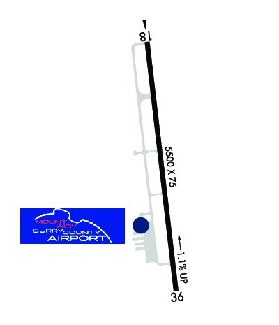
| Lat: N 3627.7 Long: W 08033.2 Elev: 1269 Var: +07 Longest Runway: 5500 | ||
| AWOS: 121.12 CTAF: 123.0 | ||
| ||||||||||||||||||||||||||||||||||||||||||||||||||||||||||||||||||||
| ||||||||||||||||||||||||||||||||||||||||||||||||||||||||||||||||||||
| ||||||||||||||||||||||||||||||||||||||||||||||||||||||||||||||||||||
| Rwy | Rwy | |||||||
| 5500x75 | 5500' | 5500x75 | 5500' | |||||
| Runway ID | Single Wheel | Double Wheel | Double Tandem Wheel | Dual Double Wheel |
| 18/36 | 27,000 | 42,000 | N/A | N/A |
| These numbers are Advisory and are not limits. The Airport Manager should have more accurate Weight Limits | ||||
 Airport Diagram might not be current. | |
| Facility Name: | MOUNT AIRY/SURRY COUNTY |
| City Name: | MOUNT AIRY |
| County: | SURRY |
| State abbrev: | NC |
| State Name: | NORTH CAROLINA |
| Ownership: | PUBLICLY OWNED |
| Use: | OPEN TO THE PUBLIC |
| Owner's Name: | CITY OF MOUNT AIRY & SURRY COUNTY |
| Address: | 146 HOWARD WOLTZ JR. WAY |
| MOUNT AIRY, NC 27030-9020 | |
| Owner's Phone: | 336-401-8201 |
| Manager's Name: | GEORGE CRATER |
| Address: | 146 HOWARD WOLTZ JR. WAY |
| MOUNT AIRY, NC 27030-9020 | |
| Phone: | 336-789-5153 |
| FAA Region: | SOUTHERN |
| FAA Field Office: | MEM |
| Date | Sunrise | Sunset |
|---|---|---|
| 03/30/25 Sunday | 7:12 | 19:43 |
| 03/31/25 Monday | 7:10 | 19:43 |
| 04/01/25 Tuesday | 7:09 | 19:44 |
| 04/02/25 Wednesday | 7:07 | 19:45 |
| 04/03/25 Thursday | 7:06 | 19:46 |
| 04/04/25 Friday | 7:04 | 19:47 |
| 04/05/25 Saturday | 7:03 | 19:48 |
| 04/06/25 Sunday | 7:01 | 19:48 |
| 04/07/25 Monday | 7:00 | 19:49 |
| 04/08/25 Tuesday | 6:59 | 19:50 |
| 04/09/25 Wednesday | 6:57 | 19:51 |
| 04/10/25 Thursday | 6:56 | 19:52 |
| 04/11/25 Friday | 6:54 | 19:53 |
| 04/12/25 Saturday | 6:53 | 19:54 |
| Airport Attendance Schedule | 7 Days A Week; 0800- (EARLIER OF) 1800 LOCAL OR SS. |
| Airport Status | OPERATIONAL (This Status can change at any time - please check NOTAMS) |
| Airport Lighting Schedule | ACTVT REIL RWY 18 & 36; PAPI RWY 18 & 36; MIRL RWY 18/36 - CTAF. |
| Airport Storage Available | Tie Downs, Hanger |
| Extra Services Available | Flight Instruction, Aircraft Rental |
| Wind Indicator | YES - (lighted) |
| Control Tower | NO |
| CTAF Frequency | 123.000 |
| Unicom Frequency | 123.000 |
| Rotating Beacon Color | WG |
| Segmented Circle | YES |
| Landing Fee | NO |
| Airport Inspected | STATE - performed by STATE AERONAUTICAL PERSONNEL |
| Inspection Date | 08/02/2024 |
| Type of Fuel Available | Grade 100LL, JET A (freeze point -40C), JET A-1 (icing inhibitor, freeze point -50C) |
| Airframe Repair Service | MAJOR |
| Power Plant Repair Service | MAJOR |
| Latitude | N3627.7 |
| Longitude | W08033.2 (ESTIMATED) |
| Arpt Elevation | 1268ft (SURVEYED) |
| Magnetic Variation | 07W |
| 3 miles SE | of MOUNT AIRY |
| Traffic Pattern Altitude | |
| Sectional Chart | CINCINNATI |
| Operations (Reported) | Yearly | Avg. Daily |
|---|---|---|
| General Aviation Transient | 0 | 0 |
| General Aviation Local | 0 | 0 |
| Air Taxi | 0 | 0 |
| Commerical | 0 | 0 |
| Commuter | 0 | 0 |
| Military | 0 | 0 |
| Aircraft based on Field | |
|---|---|
| General Aviation Singles | 0 |
| General Aviation Multi | 0 |
| Jet Aircraft | 0 |
| General Aviation Helicopters | 0 |
| Military Aircraft | 0 |
| Gliders | 0 |
| Ultralights | 0 |
| FSS on field | NO |
| FSS tie-in | RALEIGH |
| FSS Phone | 1-800-WX-BRIEF |
| Who issues Notams | MWK |
| Notam D service at airport | YES |
| ARTCC Name | ATLANTA |
| Airport Certification | |
| Aircraft Rescue & Firefighting Index | None |
| Airport of Entry | No |
| Custom Landing Rights | No |
| Joint Civil/Military | No |
| Military Landing rights | YES |
| NATIONAL PLAN OF INTEGRATED AIRPORT SYSTEMS (NPIAS) |
| ASSURANCES PURSUANT TO TITLE VI, CIVIL RIGHTS ACT OF 1964 |
| GRANT AGREEMENT HAS EXPIRED; HOWEVER, AGREEMENT REMAINS IN EFFECT FOR THIS FACILITY AS LONG AS IT IS PUBLIC USE. |
| RWY 36 SLOPES UPHILL 34 FEET. |
| AFTER HOURS SERVICE AVAILABLE/POSTED ON PHONE BOX. |
| RWY 36 - 50 FT DROP-OFF 300 FT FM THR AND 150 FT RIGHT & LEFT OF CNTRLN. |
| FOR CD CTC GREENSBORO APCH AT 743-222-6129. |
| RWY HAS 100 FT DROP-OFFS 90 FT FM CNTRLN BOTH SIDES AND 300 FT FM THR. |
Airport Communications & Frequencies:
| ||||||||||||||
| Runway: 18 | Runway: 36 | ||
| Mag heading: | 180° | Mag heading: | 360° |
| Rwy Slope: | -1.10% Down | Rwy Slope: | 1.10% Up |
| Approach: | Approach: | ||
| Pattern: | Left Traffic | Pattern: | Left Traffic |
| Markings: | NONPRECISION INSTRUMENT | Markings: | NONPRECISION INSTRUMENT |
| Marking Condition: | GOOD | Marking Condition: | GOOD |
| Arresting Dev: | Arresting Dev: | ||
| Lat & Long: | N3628.1 W08033.3 | Lat. & Long.: | N3627.2 W08033.1 |
| Elev: | 1268.9 ft. MSL | Elev: | 1208.5 ft. MSL |
| TCH: | 40 ft. AGL | TCH: | 40 ft. AGL |
| Visual Glide Path: | 3.00 degrees | Visual Glide Path: | 3.00 degrees |
| Displaced Threshold: | No | Displaced Threshold: | No |
| Touchdown Zone: | YES | Touchdown Zone: | YES |
| Touchdown Elev.: | 1268.9 feet | Touchdown Elev.: | 1227.9 feet |
| Visual Glide Slope: | 4-Light PAPI on RIGHT side of Runway | Visual Glide Slope: | 4-Light PAPI on LEFT side of Runway |
| RVR Equipment: | RVR Equipment: | ||
| RVV Equipment: | NO | RVV Equipment: | NO |
| Approach Lights: | Approach Lights: | ||
| REIL: | YES | REIL: | YES |
| Centerline Lights: | NO | Centerline Lights: | NO |
| Touchdown lights: | NO | Touchdown lights: | NO |
| Runway Category: | Runway with a Non-precision Approach having visibility minimums greater than 3/4 mile | Runway Category: | Runway with a Non-precision Approach having visibility minimums greater than 3/4 mile |
| Declared Distances: | Declared Distances: | ||
| Obstructions: | TREES | Obstructions: | OTHER |
| Marked: | NOT Marked/Lighted | Marked: | NOT Marked/Lighted |
| Clearance slope: | 21:1 | Clearance slope: | 26:1 |
| Obstruction height: | 47 feet AGL | Obstruction height: | 63 feet AGL |
| Dist. from runway: | 1219 feet | Dist. from runway: | 1842 feet |
| Centerline offset: | 275 left of centerline | Centerline offset: | 32 feet left of centerline |
| Comments: | Comments: |
Thanks for using FltPlan.com
all rights reserved © 1999-2025 by Flight Plan LLC