| MILLINGTON RGNL JETPORT MILLINGTON TN |
| |
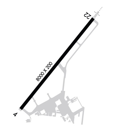
| Lat: N 3521.4 Long: W 08952.2 Elev: 319 Var: -00 Longest Runway: 8000 | ||
| AWOS: 118.92 Ground: 121.37 Tower: 120.25 | ||
| |||||||||||||||||||||||||||||||||||||||||||||||||||||||||||||||||||||
| |||||||||||||||||||||||||||||||||||||||||||||||||||||||||||||||||||||
| |||||||||||||||||||||||||||||||||||||||||||||||||||||||||||||||||||||
| |||||||||||||||||||||||||||||||||||||||||||||||||||||||||||||||||||||
| Rwy | Rwy | |||||||
| 8000x200 | 8000' | 8000x200 | 8000' | 109.75 - 219° | ||||
| Runway ID | Single Wheel | Double Wheel | Double Tandem Wheel | Dual Double Wheel |
| 04/22 | N/A | N/A | N/A | N/A |
| These numbers are Advisory and are not limits. The Airport Manager should have more accurate Weight Limits | ||||
 Airport Diagram might not be current. | |
| Facility Name: | MILLINGTON-MEMPHIS |
| City Name: | MILLINGTON |
| County: | SHELBY |
| State abbrev: | TN |
| State Name: | TENNESSEE |
| Ownership: | PUBLICLY OWNED |
| Use: | OPEN TO THE PUBLIC |
| Owner's Name: | MILLINGTON ARPT AUTH |
| Address: | 8182 HORNET AVE |
| MILLINGTON, TN 38053 | |
| Owner's Phone: | 901-872-7495 |
| Manager's Name: | MR. ROY REMINGTON |
| Address: | 8182 HORNET AVE |
| MILLINGTON, TN 38053 | |
| Phone: | 901-872-7495 |
| FAA Region: | SOUTHERN |
| FAA Field Office: | MEM |

| Date | Sunrise | Sunset |
|---|---|---|
| 09/24/21 Friday | 6:49 | 18:54 |
| 09/25/21 Saturday | 6:50 | 18:52 |
| 09/26/21 Sunday | 6:50 | 18:51 |
| 09/27/21 Monday | 6:51 | 18:49 |
| 09/28/21 Tuesday | 6:52 | 18:48 |
| 09/29/21 Wednesday | 6:53 | 18:46 |
| 09/30/21 Thursday | 6:53 | 18:45 |
| 10/01/21 Friday | 6:54 | 18:44 |
| 10/02/21 Saturday | 6:55 | 18:42 |
| 10/03/21 Sunday | 6:56 | 18:41 |
| 10/04/21 Monday | 6:57 | 18:39 |
| 10/05/21 Tuesday | 6:57 | 18:38 |
| 10/06/21 Wednesday | 6:58 | 18:37 |
| 10/07/21 Thursday | 6:59 | 18:35 |
| Airport Attendance Schedule | MON-FRI 0730-0200, SAT-SUN 0700-1900; SVC AFT HR - 901-873-4144 OR 901-873-4359. |
| Airport Status | OPERATIONAL (This Status can change at any time - please check NOTAMS) |
| Airport Lighting Schedule | ACTVT MALSR RWY 22; HIRL RWY 04/22 - CTAF. HIRL RWY 04/22 PRESET LOW INTST; INCR INTST - CTAF. PAPI'S ON CONSLY. |
| Airport Storage Available | Tie Downs, Hanger |
| Extra Services Available | Avionics |
| Wind Indicator | YES - (lighted) |
| Control Tower | YES |
| CTAF Frequency | 120.250 |
| Unicom Frequency | 122.950 |
| Rotating Beacon Color | CLEAR-GREEN (Light Land Airport) |
| Segmented Circle | YES |
| Landing Fee |
| Airport Inspected | STATE - performed by FAA AIRPORTS FIELD PERSONNEL |
| Inspection Date | 08/21/2019 |
| Type of Fuel Available | Grade 100LL, JET A; -10JASU AVBL. |
| Airframe Repair Service | MAJOR |
| Power Plant Repair Service | MAJOR |
| Latitude | N3521.4 |
| Longitude | W08952.2 (ESTIMATED) |
| Arpt Elevation | 319ft (SURVEYED) |
| Magnetic Variation | 00E |
| 1 miles NE | of MILLINGTON |
| Traffic Pattern Altitude | |
| Sectional Chart | MEMPHIS |
| Operations (Reported) | Yearly | Avg. Daily |
|---|---|---|
| General Aviation Transient | 17075 | 47 |
| General Aviation Local | 8008 | 22 |
| Air Taxi | 405 | 1 |
| Commerical | 2 | 0 |
| Commuter | 0 | 0 |
| Military | 5692 | 16 |
| Aircraft based on Field | |
|---|---|
| General Aviation Singles | 61 |
| General Aviation Multi | 12 |
| Jet Aircraft | 0 |
| General Aviation Helicopters | 2 |
| Military Aircraft | 0 |
| Gliders | 0 |
| Ultralights | 0 |
| FSS on field | NO |
| FSS tie-in | JACKSON |
| FSS Phone | 1-800-WX-BRIEF |
| Who issues Notams | NQA |
| Notam D service at airport | YES |
| ARTCC Name | MEMPHIS |
| Airport Certification | ARPT CLSD TO UNSKED ACR OPS WITH MORE THAN 30 PAX SEATS. ARFF NOT AVBL MON 1130-0300Z; TUE-SAT 0800-1130Z; SAT-SUN 2000-1130Z EXC PPR. INDEX D ARFF AVBL PPR - 901-873-5792. |
| Aircraft Rescue & Firefighting Index | AIRPORT HAS A CERTIFICATE UNDER CFR PART 139 |
| Airport of Entry | No |
| Custom Landing Rights | No |
| Joint Civil/Military | No |
| Military Landing rights | YES |
| NATIONAL PLAN OF INTEGRATED AIRPORT SYSTEMS (NPIAS) |
| CAT C AFLD. |
| TWY B CLSD TO ACR. |
| FOR CD WHEN ATCT IS CLSD CTC MEM APCH AT 901-842-8457. |
| RWY 04/2 2 FIRST 1000 FT BOTH ENDS & 3000 FT OF NE PORTION NOT GROOVED. |
Airport Communications & Frequencies:
| ||||||||||||||||||||||||||||||||||||||||||||
| Runway: 04 | Runway: 22 | ||
| Mag heading: | 39° | Mag heading: | 219° |
| Rwy Slope: | .55% Up | Rwy Slope: | -.55% Down |
| Approach: | Approach: | ILS/DME | |
| Pattern: | Left Traffic | Pattern: | Right Traffic |
| Markings: | PRECISION INSTRUMENT | Markings: | PRECISION INSTRUMENT |
| Marking Condition: | GOOD | Marking Condition: | GOOD |
| Arresting Dev: | Arresting Dev: | ||
| Lat & Long: | N3520.9 W08952.7 | Lat. & Long.: | N3521.9 W08951.7 |
| Elev: | 275.3 ft. MSL | Elev: | 319.3 ft. MSL |
| TCH: | 73 ft. AGL | TCH: | 73 ft. AGL |
| Visual Glide Path: | 3.00 degrees | Visual Glide Path: | 3.00 degrees |
| Displaced Threshold: | No | Displaced Threshold: | No |
| Touchdown Zone: | YES | Touchdown Zone: | YES |
| Touchdown Elev.: | 291.6 feet | Touchdown Elev.: | 319.4 feet |
| Visual Glide Slope: | 4-Light PAPI on LEFT side of Runway | Visual Glide Slope: | 4-Light PAPI on LEFT side of Runway |
| RVR Equipment: | RVR Equipment: | ||
| RVV Equipment: | NO | RVV Equipment: | NO |
| Approach Lights: | Approach Lights: | MALSR - 1,400 foot medium intensity approach lighting system with runway alignment indicator lights | |
| REIL: | NO | REIL: | NO |
| Centerline Lights: | NO | Centerline Lights: | NO |
| Touchdown lights: | NO | Touchdown lights: | NO |
| Runway Category: | Runway with a Non-precision Approach having visibility minimums greater than 3/4 mile | Runway Category: | Precision Instrument Runway |
| Declared Distances: | Declared Distances: |
Thanks for using FltPlan.com
all rights reserved © 1999-2021 by Flight Plan LLC