
| KARL STEFAN MEMORIAL NORFOLK NE |
| |
| Lat: N 4159.1 Long: W 09726.1 Elev: 1573 Var: -05 Longest Runway: 5806 | ||
| AWOS: 119.02 CTAF: 122.7 | ||
| ||||||||||||||||||||||||||||||||||||||||||||
| ||||||||||||||||||||||||||||||||||||||||||||
| ||||||||||||||||||||||||||||||||||||||||||||
| Rwy | Rwy | |||||||
| 5801x100 | 5801' | 111.50 - 014° | 5801x100 | 5504' | ||||
| 5806x100 | 5519' | 5806x100 | 5446' | |||||
| Runway ID | Single Wheel | Double Wheel | Double Tandem Wheel | Dual Double Wheel |
| 02/20 | 60,000 | 192,000 | 360,000 | N/A |
| 14/32 | 75,000 | 192,000 | 400,000 | N/A |
| These numbers are Advisory and are not limits. The Airport Manager should have more accurate Weight Limits | ||||
 Airport Diagram might not be current. | |
| Facility Name: | NORFOLK RGNL/KARL STEFAN MEML FLD |
| City Name: | NORFOLK |
| County: | MADISON |
| State abbrev: | NE |
| State Name: | NEBRASKA |
| Ownership: | PUBLICLY OWNED |
| Use: | OPEN TO THE PUBLIC |
| Owner's Name: | NORFOLK AIRPORT AUTHORITY |
| Address: | P.O. BOX 1343 |
| NORFOLK, NE 68702-1343 | |
| Owner's Phone: | 402-841-5130 |
| Manager's Name: | MR JUSTIN MARTIN |
| Address: | P.O. BOX 1343 |
| NORFOLK, NE 68702-1343 | |
| Phone: | 402-841-5130 |
| FAA Region: | CENTRAL |
| FAA Field Office: | NONE |

| Date | Sunrise | Sunset |
|---|---|---|
| 06/19/25 Thursday | 5:54 | 21:08 |
| 06/20/25 Friday | 5:54 | 21:09 |
| 06/21/25 Saturday | 5:54 | 21:09 |
| 06/22/25 Sunday | 5:54 | 21:09 |
| 06/23/25 Monday | 5:55 | 21:09 |
| 06/24/25 Tuesday | 5:55 | 21:09 |
| 06/25/25 Wednesday | 5:55 | 21:09 |
| 06/26/25 Thursday | 5:56 | 21:09 |
| 06/27/25 Friday | 5:56 | 21:09 |
| 06/28/25 Saturday | 5:56 | 21:09 |
| 06/29/25 Sunday | 5:57 | 21:09 |
| 06/30/25 Monday | 5:57 | 21:09 |
| 07/01/25 Tuesday | 5:58 | 21:09 |
| 07/02/25 Wednesday | 5:58 | 21:09 |
| Airport Attendance Schedule | SAT 0700-1700, SUN 1000-1700, M-F 0700-1900; FOR SVC AFT HRS CALL 402-841-5130 |
| Airport Status | OPERATIONAL (This Status can change at any time - please check NOTAMS) |
| Airport Lighting Schedule | ACTVT MALSR RWY 02; REIL RWY 20; PAPI RWYS 02, 20, 14, & 32; HIRL RWY 02/20; MIRL RWY 14/32 - CTAF. |
| Airport Storage Available | Tie Downs, Hanger |
| Extra Services Available | Crop Dusting, Flight Instruction, Aircraft Rental |
| Wind Indicator | YES - (lighted) |
| Control Tower | NO |
| CTAF Frequency | 122.700 |
| Unicom Frequency | 122.700 |
| Rotating Beacon Color | WG |
| Segmented Circle | YES |
| Landing Fee | NO |
| Airport Inspected | FEDERAL - performed by STATE AERONAUTICAL PERSONNEL |
| Inspection Date | 05/05/2025 |
| Type of Fuel Available | Grade 100LL, JET A; -10SELF SVC FUEL AVBL H24 100LL ONLY. |
| Airframe Repair Service | MINOR |
| Power Plant Repair Service | MINOR; ENGINE OVERHAULS NOT PERFORMED IN-HOUSE. |
| Latitude | N4159.1 |
| Longitude | W09726.1 (ESTIMATED) |
| Arpt Elevation | 1572ft (SURVEYED) |
| Magnetic Variation | 05E |
| 3 miles SW | of NORFOLK |
| Traffic Pattern Altitude | |
| Sectional Chart | OMAHA |
| Operations (Reported) | Yearly | Avg. Daily |
|---|---|---|
| General Aviation Transient | 0 | 0 |
| General Aviation Local | 0 | 0 |
| Air Taxi | 0 | 0 |
| Commerical | 0 | 0 |
| Commuter | 0 | 0 |
| Military | 0 | 0 |
| Aircraft based on Field | |
|---|---|
| General Aviation Singles | 0 |
| General Aviation Multi | 0 |
| Jet Aircraft | 0 |
| General Aviation Helicopters | 0 |
| Military Aircraft | 0 |
| Gliders | 0 |
| Ultralights | 0 |
| FSS on field | NO |
| FSS tie-in | COLUMBUS |
| FSS Phone | 1-800-WX-BRIEF |
| Who issues Notams | OFK |
| Notam D service at airport | YES |
| ARTCC Name | MINNEAPOLIS |
| Airport Certification | |
| Aircraft Rescue & Firefighting Index | None |
| Airport of Entry | No |
| Custom Landing Rights | No |
| Joint Civil/Military | No |
| Military Landing rights | YES |
| NATIONAL PLAN OF INTEGRATED AIRPORT SYSTEMS (NPIAS) |
| GRANT AGREEMENTS UNDER FAAP/ADAP/AIP |
| ASSURANCES PURSUANT TO TITLE VI, CIVIL RIGHTS ACT OF 1964 |
| AGREEMENT UNDER DLAND OR DCLA HAS EXPIRED. |
| RWY 20 DSGND AS CALM WIND RWY. ALL RWYS HAVE L HAND TFC ONLY. |
| FOR CD IF UNA TO CTC ON FSS FREQ, CTC MINNEAPOLIS ARTCC AT 651-463-5588. |
Airport Communications & Frequencies:
| |||||||||
| Runway: 02 | Runway: 20 | ||
| Mag heading: | 14° | Mag heading: | 194° |
| Rwy Slope: | -.73% Down | Rwy Slope: | .73% Up |
| Approach: | ILS | Approach: | |
| Pattern: | Left Traffic | Pattern: | Left Traffic |
| Markings: | PRECISION INSTRUMENT | Markings: | NONPRECISION INSTRUMENT |
| Marking Condition: | GOOD | Marking Condition: | GOOD |
| Arresting Dev: | Arresting Dev: | ||
| Lat & Long: | N4158.7 W09726.3 | Lat. & Long.: | N4159.6 W09725.8 |
| Elev: | 1572.6 ft. MSL | Elev: | 1530.5 ft. MSL |
| TCH: | 49 ft. AGL | TCH: | 40 ft. AGL |
| Visual Glide Path: | 3.00 degrees | Visual Glide Path: | 3.00 degrees |
| Displaced Threshold: | No | Displaced Threshold: | 297 feet |
| Touchdown Zone: | YES | Touchdown Zone: | YES |
| Touchdown Elev.: | 1572.6 feet | Touchdown Elev.: | 1541.5 feet |
| Visual Glide Slope: | 4-Light PAPI on LEFT side of Runway | Visual Glide Slope: | 4-Light PAPI on LEFT side of Runway |
| RVR Equipment: | RVR Equipment: | ||
| RVV Equipment: | NO | RVV Equipment: | NO |
| Approach Lights: | MALSR - 1,400 foot medium intensity approach lighting system with runway alignment indicator lights | Approach Lights: | |
| REIL: | NO | REIL: | YES |
| Centerline Lights: | NO | Centerline Lights: | NO |
| Touchdown lights: | NO | Touchdown lights: | NO |
| Runway Category: | Precision Instrument Runway | Runway Category: | Runway with a Non-precision Approach having visibility minimums greater than 3/4 mile |
| Declared Distances: | Declared Distances: | ||
| Obstructions: | FENCE | Obstructions: | TREE |
| Marked: | NOT Marked/Lighted | Marked: | NOT Marked/Lighted |
| Clearance slope: | 36:1 | Clearance slope: | 16:1 |
| Obstruction height: | 27 feet AGL | Obstruction height: | 73 feet AGL |
| Dist. from runway: | 1182 feet | Dist. from runway: | 1391 feet |
| Centerline offset: | 647 right of centerline | Centerline offset: | 597 feet right of centerline |
| Comments: | Comments: |
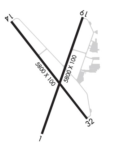
| Runway: 14 | Runway: 32 | ||
| Mag heading: | 137° | Mag heading: | 317° |
| Rwy Slope: | .37% Up | Rwy Slope: | -.37% Down |
| Approach: | Approach: | ||
| Pattern: | Left Traffic | Pattern: | Left Traffic |
| Markings: | NONPRECISION INSTRUMENT | Markings: | NONPRECISION INSTRUMENT |
| Marking Condition: | GOOD | Marking Condition: | GOOD |
| Arresting Dev: | Arresting Dev: | ||
| Lat & Long: | N4159.5 W09726.6 | Lat. & Long.: | N4158.8 W09725.8 |
| Elev: | 1542.8 ft. MSL | Elev: | 1564.1 ft. MSL |
| TCH: | 40 ft. AGL | TCH: | 49 ft. AGL |
| Visual Glide Path: | 3.00 degrees | Visual Glide Path: | 3.50 degrees |
| Displaced Threshold: | 287 feet | Displaced Threshold: | 360 feet |
| Touchdown Zone: | YES | Touchdown Zone: | YES |
| Touchdown Elev.: | 1543.4 feet | Touchdown Elev.: | 1559.9 feet |
| Visual Glide Slope: | 4-Light PAPI on LEFT side of Runway | Visual Glide Slope: | 4-Light PAPI on LEFT side of Runway |
| RVR Equipment: | RVR Equipment: | ||
| RVV Equipment: | NO | RVV Equipment: | NO |
| Approach Lights: | Approach Lights: | ||
| REIL: | NO | REIL: | NO |
| Centerline Lights: | NO | Centerline Lights: | NO |
| Touchdown lights: | NO | Touchdown lights: | NO |
| Runway Category: | Runway with a Non-precision Approach having visibility minimums greater than 3/4 mile | Runway Category: | Runway with a Non-precision Approach having visibility minimums greater than 3/4 mile |
| Declared Distances: | TORA:5443' TODA:5800' ASDA:5443' LDA:5160' | Declared Distances: | TORA:5517' TODA:5800' ASDA:5517' LDA:5160' |
| Obstructions: | RR | Obstructions: | TREE |
| Marked: | NOT Marked/Lighted | Marked: | NOT Marked/Lighted |
| Clearance slope: | 26:1; CLNC SLP TO DTHR 42:1 DUE TO RR 1185 FT FM DTHR 428 FT R. | Clearance slope: | 22:1; CLNC SLP TO DTHR 32:1 DUE TO 59 FT TREE 1895 FT FM DTHR 105 FT R. |
| Obstruction height: | 28 feet AGL | Obstruction height: | 59 feet AGL |
| Dist. from runway: | 952 feet | Dist. from runway: | 1535 feet |
| Centerline offset: | 364 right of centerline | Centerline offset: | 105 feet right of centerline |
| Comments: | Comments: |
Thanks for using FltPlan.com
all rights reserved © 1999-2025 by Flight Plan LLC