
| NORFOLK INTL NORFOLK VA |
| |
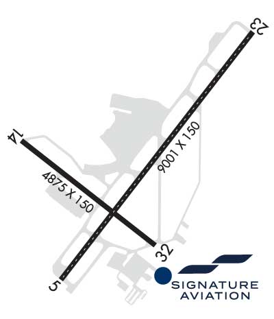
| Lat: N 3653.7 Long: W 07612.1 Elev: 26 Var: +09 Longest Runway: 9001 | ||
| Clr Del: 118.5 Dept. ATIS: 127.15 Arr. ATIS: 127.15 Ground: 121.9 Tower: 120.8 | ||
| ||||||||||||||||||||||||||||||||||||||||||||||||||||||||||||||||||||
| ||||||||||||||||||||||||||||||||||||||||||||||||||||||||||||||||||||
| ||||||||||||||||||||||||||||||||||||||||||||||||||||||||||||||||||||
| ||||||||||||||||||||||||||||||||||||||||||||||||||||||||||||||||||||
| Rwy | Rwy | |||||||
| 9001x150 | 8000' | 109.10 - 046° | 9001x150 | 9001' | 109.10 - 226° | |||
| 4876x150 | 4301' | 4876x150 | 4876' | |||||
| Runway ID | Single Wheel | Double Wheel | Double Tandem Wheel | Dual Double Wheel |
| 05/23 | 150,000 | 200,000 | 350,000 | 475,000 |
| 14/32 | 75,000 | 100,000 | N/A | N/A |
| These numbers are Advisory and are not limits. The Airport Manager should have more accurate Weight Limits | ||||
 Airport Diagram might not be current. | |
| Facility Name: | NORFOLK INTL |
| City Name: | NORFOLK |
| County: | NORFOLK |
| State abbrev: | VA |
| State Name: | VIRGINIA |
| Ownership: | PUBLICLY OWNED |
| Use: | OPEN TO THE PUBLIC |
| Owner's Name: | NORFOLK AIRPORT AUTH |
| Address: | 2200 NORVIEW AVE |
| NORFOLK, VA 23518-5807 | |
| Owner's Phone: | 757-857-3351 |
| Manager's Name: | ROBERT BOWEN, EXEC DIR |
| Address: | 2200 NORVIEW AVE |
| NORFOLK, VA 23518-5807 | |
| Phone: | 757-857-3344; POLICE DISPATCH. |
| FAA Region: | EASTERN |
| FAA Field Office: | DCA |
| Date | Sunrise | Sunset |
|---|---|---|
| 09/24/21 Friday | 6:54 | 18:59 |
| 09/25/21 Saturday | 6:55 | 18:58 |
| 09/26/21 Sunday | 6:56 | 18:56 |
| 09/27/21 Monday | 6:57 | 18:55 |
| 09/28/21 Tuesday | 6:57 | 18:53 |
| 09/29/21 Wednesday | 6:58 | 18:52 |
| 09/30/21 Thursday | 6:59 | 18:50 |
| 10/01/21 Friday | 7:00 | 18:49 |
| 10/02/21 Saturday | 7:01 | 18:47 |
| 10/03/21 Sunday | 7:02 | 18:46 |
| 10/04/21 Monday | 7:02 | 18:44 |
| 10/05/21 Tuesday | 7:03 | 18:43 |
| 10/06/21 Wednesday | 7:04 | 18:41 |
| 10/07/21 Thursday | 7:05 | 18:40 |
| Airport Attendance Schedule | CONTINUOUS |
| Airport Status | OPERATIONAL (This Status can change at any time - please check NOTAMS) |
| Airport Lighting Schedule | SS-SR |
| Airport Storage Available | Tie Downs, Hanger |
| Extra Services Available | Avionics, Cargo Handling, Charter, Flight Instruction |
| Wind Indicator | YES - (lighted) |
| Control Tower | YES |
| CTAF Frequency | |
| Unicom Frequency | |
| Rotating Beacon Color | CLEAR-GREEN (Light Land Airport) |
| Segmented Circle | NO |
| Landing Fee | YES |
| Airport Inspected | FEDERAL - performed by FAA AIRPORTS FIELD PERSONNEL |
| Inspection Date | 06/14/2021 |
| Type of Fuel Available | Grade 100LL, JET A (freeze point -40C) |
| Airframe Repair Service | MINOR |
| Power Plant Repair Service | MINOR |
| Latitude | N3653.7 |
| Longitude | W07612.1 (ESTIMATED) |
| Arpt Elevation | 26ft (SURVEYED) |
| Magnetic Variation | 09W |
| 3 miles NE | of NORFOLK |
| Traffic Pattern Altitude | |
| Sectional Chart | WASHINGTON |
| Operations (Reported) | Yearly | Avg. Daily |
|---|---|---|
| General Aviation Transient | 12886 | 35 |
| General Aviation Local | 237 | 1 |
| Air Taxi | 8850 | 24 |
| Commerical | 25282 | 69 |
| Commuter | 0 | 0 |
| Military | 422 | 1 |
| Aircraft based on Field | |
|---|---|
| General Aviation Singles | 44 |
| General Aviation Multi | 10 |
| Jet Aircraft | 29 |
| General Aviation Helicopters | 2 |
| Military Aircraft | 0 |
| Gliders | 0 |
| Ultralights | 0 |
| FSS on field | NO |
| FSS tie-in | LEESBURG |
| FSS Phone | 1-800-WX-BRIEF |
| Who issues Notams | ORF |
| Notam D service at airport | YES |
| ARTCC Name | WASHINGTON |
| Airport Certification | AIRPORT RECEIVING SCHEDULED AIR CARRIER SERVICE FROM CARRIERS CERTIFICATED BY THE CIVIL AERONAUTICS BOARD |
| Aircraft Rescue & Firefighting Index | AIRPORT HAS A CERTIFICATE UNDER CFR PART 139 |
| Airport of Entry | No |
| Custom Landing Rights | YES |
| Joint Civil/Military | No |
| Military Landing rights | YES |
| NATIONAL PLAN OF INTEGRATED AIRPORT SYSTEMS (NPIAS) |
| GRANT AGREEMENTS UNDER FAAP/ADAP/AIP |
| COMPLIANCE WITH ACCESSIBILITY TO THE HANDICAPPED |
| SURPLUS PROPERTY AGREEMENT UNDER REGULATION 16-WAA |
| ASSURANCES PURSUANT TO TITLE VI, CIVIL RIGHTS ACT OF 1964 |
| AGREEMENT UNDER DLAND OR DCLA HAS EXPIRED. |
| NOISE ABATEMENT PROCEDURES IN EFFECT. |
| FLOCKS OF BIRDS ON & INVOF ARPT. |
| INTMT AIRFIELD MOWING OPS MAR - NOV. |
| ORF OBBST CRANE (ASN 2019-AEA-2060-NRA) 365354N0761228W (0,4 NW NW ORF) 230 FT (210FT AGL) FLAGGED AND LGTD 2008181100-2104302300 |
Airport Communications & Frequencies:
| |||||||||||||||||||||||||||||||||||||||||
| Runway: 05 | Runway: 23 | ||
| Mag heading: | 47° | Mag heading: | 227° |
| Rwy Slope: | -.03% Down | Rwy Slope: | .03% Up |
| Approach: | ILS/DME | Approach: | ILS/DME |
| Pattern: | Right Traffic | Pattern: | Left Traffic |
| Markings: | PRECISION INSTRUMENT | Markings: | PRECISION INSTRUMENT |
| Marking Condition: | GOOD | Marking Condition: | GOOD |
| Arresting Dev: | Arresting Dev: | ||
| Lat & Long: | N3653.2 W07612.5 | Lat. & Long.: | N3654.3 W07611.4 |
| Elev: | 17.7 ft. MSL | Elev: | 15.0 ft. MSL |
| TCH: | 71 ft. AGL | TCH: | 55 ft. AGL |
| Visual Glide Path: | 3.00 degrees | Visual Glide Path: | 3.00 degrees |
| Displaced Threshold: | 1001 feet | Displaced Threshold: | No |
| Touchdown Zone: | YES | Touchdown Zone: | YES |
| Touchdown Elev.: | 26.1 feet | Touchdown Elev.: | 25.8 feet |
| Visual Glide Slope: | 4-Light PAPI on LEFT side of Runway | Visual Glide Slope: | 4-Light PAPI on LEFT side of Runway |
| RVR Equipment: | TOUCHDOWN | RVR Equipment: | ROLLOUT |
| RVV Equipment: | YES | RVV Equipment: | NO |
| Approach Lights: | MALSR - 1,400 foot medium intensity approach lighting system with runway alignment indicator lights | Approach Lights: | MALSR - 1,400 foot medium intensity approach lighting system with runway alignment indicator lights |
| REIL: | NO | REIL: | NO |
| Centerline Lights: | YES | Centerline Lights: | YES |
| Touchdown lights: | NO | Touchdown lights: | NO |
| Runway Category: | Precision Instrument Runway | Runway Category: | Precision Instrument Runway |
| Declared Distances: | TORA:9001' TODA:9001' ASDA:8809' LDA:7809' | Declared Distances: | TORA:9001' TODA:9001' ASDA:8995' LDA:8995' |
| Obstructions: | TREES | Obstructions: | POLE |
| Marked: | NOT Marked/Lighted | Marked: | LIGHTED |
| Clearance slope: | 46:1; APCH RATIO 50:1 TO DSPLCD THR. | Clearance slope: | 26:1 |
| Obstruction height: | 41 feet AGL | Obstruction height: | 49 feet AGL |
| Dist. from runway: | 2100 feet | Dist. from runway: | 1500 feet |
| Centerline offset: | 380 left of centerline | Centerline offset: | 150 feet right of centerline |
| Comments: | Comments: | RWY 23 +1' FNC 80' FM RY END 400' R 10' FCN 0-200 270' L |
| Runway: 14 | Runway: 32 | ||
| Mag heading: | 137° | Mag heading: | 317° |
| Rwy Slope: | .08% Up | Rwy Slope: | -.08% Down |
| Approach: | Approach: | ||
| Pattern: | Right Traffic | Pattern: | Left Traffic |
| Markings: | NONPRECISION INSTRUMENT | Markings: | NONPRECISION INSTRUMENT |
| Marking Condition: | GOOD | Marking Condition: | GOOD |
| Arresting Dev: | Arresting Dev: | ||
| Lat & Long: | N3653.8 W07612.7 | Lat. & Long.: | N3653.3 W07611.9 |
| Elev: | 17.7 ft. MSL | Elev: | 21.7 ft. MSL |
| TCH: | 36 ft. AGL | TCH: | 34 ft. AGL |
| Visual Glide Path: | 3.00 degrees | Visual Glide Path: | 3.00 degrees |
| Displaced Threshold: | 575 feet | Displaced Threshold: | No |
| Touchdown Zone: | YES | Touchdown Zone: | YES |
| Touchdown Elev.: | 24.3 feet | Touchdown Elev.: | 24.3 feet |
| Visual Glide Slope: | 2-Light PAPI on LEFT side of Runway | Visual Glide Slope: | 2-Light PAPI on LEFT side of Runway |
| RVR Equipment: | RVR Equipment: | ||
| RVV Equipment: | NO | RVV Equipment: | NO |
| Approach Lights: | Approach Lights: | ||
| REIL: | YES | REIL: | YES |
| Centerline Lights: | NO | Centerline Lights: | NO |
| Touchdown lights: | NO | Touchdown lights: | NO |
| Runway Category: | Runway with a Non-precision Approach having visibility minimums greater than 3/4 mile | Runway Category: | Runway with a Non-precision Approach having visibility minimums greater than 3/4 mile |
| Declared Distances: | TORA:4875' TODA:4875' ASDA:4875' LDA:4300' | Declared Distances: | TORA:4875' TODA:4875' ASDA:3900' LDA:3900' |
| Obstructions: | TREE | Obstructions: | TREE |
| Marked: | NOT Marked/Lighted | Marked: | NOT Marked/Lighted |
| Clearance slope: | 16:1; APCH RATIO 26:1 TO DSPLCD THR. | Clearance slope: | 23:1 |
| Obstruction height: | 61 feet AGL | Obstruction height: | 103 feet AGL |
| Dist. from runway: | 1226 feet | Dist. from runway: | 2590 feet |
| Centerline offset: | 74B | Centerline offset: | 430 feet left of centerline |
| Comments: | Comments: |
Thanks for using FltPlan.com
all rights reserved © 1999-2021 by Flight Plan LLC


