| ST PETERSBURG-CLEARWATER INTL ST PETERSBURG-CLEARW FL |
| |
| Lat: N 2754.5 Long: W 08241.2 Elev: 11 Var: +05 Longest Runway: 9730 | ||
| Clr Del: 120.6 Dept. ATIS: 134.5 Arr. ATIS: 134.5 AWOS: 134.5 Ground: 121.9 Tower: 118.3/128.4 | ||
| |||||||||||||||||||||||||||||||||||||||||||||||||||||||||||||||||||||
| |||||||||||||||||||||||||||||||||||||||||||||||||||||||||||||||||||||
| |||||||||||||||||||||||||||||||||||||||||||||||||||||||||||||||||||||
| |||||||||||||||||||||||||||||||||||||||||||||||||||||||||||||||||||||
| |||||||||||||||||||||||||||||||||||||||||||||||||||||||||||||||||||||
| Rwy | Rwy | |||||||
| 6000x150 | 6000' | 6000x150 | 6000' | |||||
| 9730x150 | 9730' | 109.10 - 176° | 9730x150 | 8800' | 108.70 - 356° | |||
| Runway ID | Single Wheel | Double Wheel | Double Tandem Wheel | Dual Double Wheel |
| 04/22 | 91,000 | 153,000 | 252,000 | N/A |
| 18/36 | 120,000 | 218,000 | 413,000 | 866,000 |
| These numbers are Advisory and are not limits. The Airport Manager should have more accurate Weight Limits | ||||
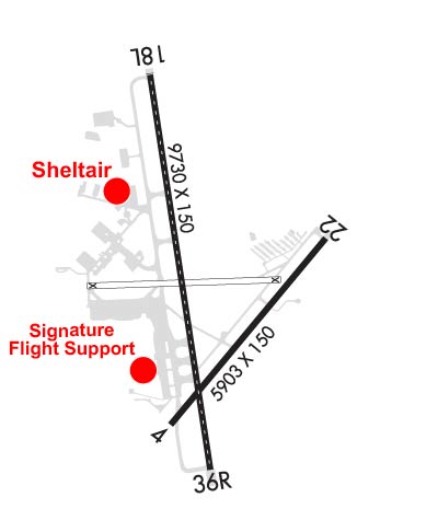 Airport Diagram might not be current. | |
| Facility Name: | ST PETE-CLEARWATER INTL |
| City Name: | ST PETERSBURG-CLEARWATER |
| County: | PINELLAS |
| State abbrev: | FL |
| State Name: | FLORIDA |
| Ownership: | PUBLICLY OWNED |
| Use: | OPEN TO THE PUBLIC |
| Owner's Name: | COUNTY OF PINELLAS |
| Address: | ST. PETE-CLEARWATER INTERNATIONAL, TERMINAL BLVD. SUITE 221 |
| CLEARWATER, FL 33762 | |
| Owner's Phone: | 727-453-7800 |
| Manager's Name: | THOMAS JEWSBURY |
| Address: | ST PETE-CLEARWATER INTERNATIONAL |
| CLEARWATER, FL 33762 | |
| Phone: | 727-453-7800 |
| FAA Region: | SOUTHERN |
| FAA Field Office: | ORL |

| Date | Sunrise | Sunset |
|---|---|---|
| 04/25/25 Friday | 6:56 | 20:01 |
| 04/26/25 Saturday | 6:56 | 20:02 |
| 04/27/25 Sunday | 6:55 | 20:03 |
| 04/28/25 Monday | 6:54 | 20:03 |
| 04/29/25 Tuesday | 6:53 | 20:04 |
| 04/30/25 Wednesday | 6:52 | 20:04 |
| 05/01/25 Thursday | 6:51 | 20:05 |
| 05/02/25 Friday | 6:50 | 20:06 |
| 05/03/25 Saturday | 6:50 | 20:06 |
| 05/04/25 Sunday | 6:49 | 20:07 |
| 05/05/25 Monday | 6:48 | 20:07 |
| 05/06/25 Tuesday | 6:47 | 20:08 |
| 05/07/25 Wednesday | 6:47 | 20:08 |
| 05/08/25 Thursday | 6:46 | 20:09 |
| Airport Attendance Schedule | CONTINUOUS |
| Airport Status | OPERATIONAL (This Status can change at any time - please check NOTAMS) |
| Airport Lighting Schedule | WHEN ATCT CLSD ACTVT MALSR RWY 18; TDZ RWY 18; CNTLN RWY 18/36; MIRL RWY 04/22; HIRL RWY 18/36; TWY LGTS - CTAF. |
| Airport Storage Available | Tie Downs, Hanger |
| Extra Services Available | Air Freight, Air Ambulance, Charter, Flight Instruction, Aircraft Rental |
| Wind Indicator | YES - (lighted) |
| Control Tower | YES |
| CTAF Frequency | 118.300 |
| Unicom Frequency | 122.950 |
| Rotating Beacon Color | WG |
| Segmented Circle | NO |
| Landing Fee | NO |
| Airport Inspected | FEDERAL - performed by FAA AIRPORTS FIELD PERSONNEL |
| Inspection Date | 01/22/2025 |
| Type of Fuel Available | Grade 100, JET A (freeze point -40C), JET A-1 (icing inhibitor, freeze point -50C) |
| Airframe Repair Service | MAJOR |
| Power Plant Repair Service | MAJOR |
| Latitude | N2754.5 |
| Longitude | W08241.2 (ESTIMATED) |
| Arpt Elevation | 10ft (SURVEYED) |
| Magnetic Variation | 05W |
| 8 miles N | of ST PETERSBURG-CLEARWATER |
| Traffic Pattern Altitude | |
| Sectional Chart | MIAMI |
| Operations (Reported) | Yearly | Avg. Daily |
|---|---|---|
| General Aviation Transient | 0 | 0 |
| General Aviation Local | 0 | 0 |
| Air Taxi | 0 | 0 |
| Commerical | 0 | 0 |
| Commuter | 0 | 0 |
| Military | 0 | 0 |
| Aircraft based on Field | |
|---|---|
| General Aviation Singles | 0 |
| General Aviation Multi | 0 |
| Jet Aircraft | 0 |
| General Aviation Helicopters | 0 |
| Military Aircraft | 0 |
| Gliders | 0 |
| Ultralights | 0 |
| FSS on field | NO |
| FSS tie-in | SAINT PETERSBURG |
| FSS Phone | 1-800-WX-BRIEF |
| Who issues Notams | PIE |
| Notam D service at airport | YES |
| ARTCC Name | MIAMI |
| Airport Certification | AIRPORT RECEIVING SCHEDULED AIR CARRIER SERVICE FROM CARRIERS CERTIFICATED BY THE CIVIL AERONAUTICS BOARD |
| Aircraft Rescue & Firefighting Index | AIRPORT HAS A CERTIFICATE UNDER CFR PART 139 |
| Airport of Entry | No |
| Custom Landing Rights | YES |
| Joint Civil/Military | No |
| Military Landing rights | YES |
| NATIONAL PLAN OF INTEGRATED AIRPORT SYSTEMS (NPIAS) |
| GRANT AGREEMENTS UNDER FAAP/ADAP/AIP |
| SURPLUS PROPERTY AGREEMENT UNDER PUBLIC LAW 289 |
| SURPLUS PROPERTY AGREEMENT UNDER REGULATION 16-WAA |
| ASSURANCES PURSUANT TO TITLE VI, CIVIL RIGHTS ACT OF 1964 |
| AGREEMENT UNDER DLAND OR DCLA HAS EXPIRED. |
| BANNER TOWING NA. |
| BIRDS ON & INVOF ARPT. |
| FOR CD IF UNA TO CTC ON FSS FREQ, CTC TAMPA APCH AT 813-878-2528. |
| PPR RQRD FOR ALL TRANS ACFT REQUESTING TO PRK ON CLEARWATER USAR MIL RAMP/APRON. MUST CTC CLEARWATER ARMY SUPPORT FAC OPS AT (910)-771-3046 OR ASF MACDILL AT (813)-828-3183/3180 UP TO 7 DAYS BFR ARR. MIN NOTICE IS 24 HOURS BFR ARR. 1000Z-0300Z M-TH OR FRI 1000Z-1830Z EXCLUDING HOLIDAYS & WEEKENDS. |
| NOISE SENSITIVE AREA 5 MI N EXTDG 1 MI E & W OF LOC SB TO SHORELINE. |
| MILITARY: CONTRACT AVOIL O-128 AVBL. |
| TBJT LNDG RWY 18 & DEP RWY 36 USE PUBLD NOISE ABATEMENT PROC. |
| LGTS ON HWY N OF ARPT MAY BE MISTAKEN FOR RWY LGTS. |
Airport Communications & Frequencies:
| ||||||||||||||||||||||||||||||
| Runway: 04 | Runway: 22 | ||
| Mag heading: | 45° | Mag heading: | 225° |
| Rwy Slope: | -.09% Down | Rwy Slope: | .09% Up |
| Approach: | Approach: | ||
| Pattern: | Left Traffic | Pattern: | Left Traffic |
| Markings: | NONPRECISION INSTRUMENT | Markings: | NONPRECISION INSTRUMENT |
| Marking Condition: | GOOD | Marking Condition: | GOOD |
| Arresting Dev: | Arresting Dev: | ||
| Lat & Long: | N2754.0 W08241.4 | Lat. & Long.: | N2754.7 W08240.6 |
| Elev: | 10.7 ft. MSL | Elev: | 5.1 ft. MSL |
| TCH: | 57 ft. AGL | TCH: | 45 ft. AGL |
| Visual Glide Path: | 3.00 degrees | Visual Glide Path: | 3.00 degrees |
| Displaced Threshold: | No | Displaced Threshold: | No |
| Touchdown Zone: | YES | Touchdown Zone: | YES |
| Touchdown Elev.: | 10.7 feet | Touchdown Elev.: | 7.4 feet |
| Visual Glide Slope: | 4-Light PAPI on LEFT side of Runway | Visual Glide Slope: | 4-Light PAPI on LEFT side of Runway |
| RVR Equipment: | RVR Equipment: | ||
| RVV Equipment: | NO | RVV Equipment: | NO |
| Approach Lights: | Approach Lights: | ||
| REIL: | YES | REIL: | YES |
| Centerline Lights: | NO | Centerline Lights: | NO |
| Touchdown lights: | NO | Touchdown lights: | NO |
| Runway Category: | Runway with a Non-precision Approach having visibility minimums greater than 3/4 mile | Runway Category: | Runway with a Visual Approach |
| Declared Distances: | TORA:6000' TODA:6000' ASDA:6000' LDA:6000' | Declared Distances: | TORA:6000' TODA:6000' ASDA:6000' LDA:6000' |
| Obstructions: | TREES | Obstructions: | ROAD |
| Marked: | NOT Marked/Lighted | Marked: | NOT Marked/Lighted |
| Clearance slope: | 29:1 | Clearance slope: | 8:1; APCH RATIO 34:1 TO THR. |
| Obstruction height: | 32 feet AGL | Obstruction height: | 8 feet AGL |
| Dist. from runway: | 1135 feet | Dist. from runway: | 270 feet |
| Centerline offset: | 10 left of centerline | Centerline offset: | 250 feet left of centerline |
| Comments: | Comments: |
| Runway: 18 | Runway: 36 | ||
| Mag heading: | 176° | Mag heading: | 356° |
| Rwy Slope: | .03% Up | Rwy Slope: | -.03% Down |
| Approach: | ILS/DME | Approach: | ILS/DME |
| Pattern: | Left Traffic | Pattern: | Left Traffic |
| Markings: | PRECISION INSTRUMENT | Markings: | PRECISION INSTRUMENT |
| Marking Condition: | FAIR | Marking Condition: | FAIR |
| Arresting Dev: | Arresting Dev: | ||
| Lat & Long: | N2755.4 W08241.4 | Lat. & Long.: | N2753.8 W08241.2 |
| Elev: | 6.6 ft. MSL | Elev: | 9.8 ft. MSL |
| TCH: | 68 ft. AGL | TCH: | 76 ft. AGL |
| Visual Glide Path: | 3.00 degrees | Visual Glide Path: | 3.00 degrees |
| Displaced Threshold: | No | Displaced Threshold: | 930 feet |
| Touchdown Zone: | YES | Touchdown Zone: | YES |
| Touchdown Elev.: | 7.2 feet | Touchdown Elev.: | 10.2 feet |
| Visual Glide Slope: | 4-Light PAPI on LEFT side of Runway | Visual Glide Slope: | 4-Light PAPI on LEFT side of Runway |
| RVR Equipment: | TOUCHDOWN-MIDFIELD-ROLLOUT | RVR Equipment: | TOUCHDOWN-MIDFIELD-ROLLOUT |
| RVV Equipment: | NO | RVV Equipment: | NO |
| Approach Lights: | MALSR - 1,400 foot medium intensity approach lighting system with runway alignment indicator lights | Approach Lights: | |
| REIL: | NO | REIL: | NO |
| Centerline Lights: | YES | Centerline Lights: | YES |
| Touchdown lights: | YES | Touchdown lights: | NO |
| Runway Category: | Precision Instrument Runway | Runway Category: | Precision Instrument Runway |
| Declared Distances: | TORA:9730' TODA:9730' ASDA:9180' LDA:9180' | Declared Distances: | TORA:9730' TODA:9730' ASDA:9650' LDA:8720' |
| Obstructions: | BRUSH | Obstructions: | TREE |
| Marked: | NOT Marked/Lighted | Marked: | NOT Marked/Lighted |
| Clearance slope: | 50:1 | Clearance slope: | 8:1; APCH RATIO 50:1 TO DTHR. |
| Obstruction height: | 9 feet AGL | Obstruction height: | 30 feet AGL |
| Dist. from runway: | 665 feet | Dist. from runway: | 450 feet |
| Centerline offset: | 280 right of centerline | Centerline offset: | 425 feet left of centerline |
| Comments: | Comments: | 6 FT FENCE 200 FT BFR AER 483 FT R OF CNTRLN. |
Thanks for using FltPlan.com
all rights reserved © 1999-2025 by Flight Plan LLC