| SOUTH BEND RGNL SOUTH BEND IN |
| |
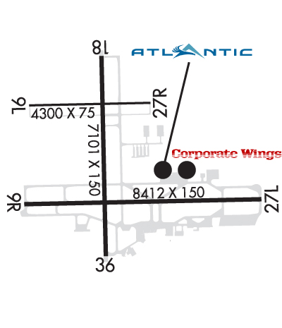
| Lat: N 4142.5 Long: W 08619.0 Elev: 798 Var: +03 Longest Runway: 8412 | ||
| Clr Del: 121.9 Dept. ATIS: 120.67 Arr. ATIS: 120.67 Ground: 121.7 Tower: 135.67 | ||
| ||||||||||||||||||||||||||||||||||||||||||||||||||||||||||||||||||||
| ||||||||||||||||||||||||||||||||||||||||||||||||||||||||||||||||||||
| ||||||||||||||||||||||||||||||||||||||||||||||||||||||||||||||||||||
| ||||||||||||||||||||||||||||||||||||||||||||||||||||||||||||||||||||
| Rwy | Rwy | |||||||
| 4300x75 | 4300' | 4300x75 | 4300' | |||||
| 8412x150 | 8412' | 109.30 - 092° | 8412x150 | 8412' | 109.30 - 271° | |||
| 7101x150 | 7101' | 7101x150 | 7101' | |||||
| Runway ID | Single Wheel | Double Wheel | Double Tandem Wheel | Dual Double Wheel |
| 09L/27R | 32,500 | 49,000 | N/A | N/A |
| 09R/27L | 120,000 | 193,000 | 313,000 | N/A |
| 18/36 | 118,000 | 186,000 | 326,000 | N/A |
| These numbers are Advisory and are not limits. The Airport Manager should have more accurate Weight Limits | ||||
 Airport Diagram might not be current. | |
| Facility Name: | SOUTH BEND INTL |
| City Name: | SOUTH BEND |
| County: | ST JOSEPH |
| State abbrev: | IN |
| State Name: | INDIANA |
| Ownership: | PUBLICLY OWNED |
| Use: | OPEN TO THE PUBLIC |
| Owner's Name: | ST JOSEPH COUNTY ARPT AUTHORITY |
| Address: | 4477 PROGRESS DRIVE |
| SOUTH BEND, IN 46628 | |
| Owner's Phone: | 574-233-2185 |
| Manager's Name: | MICHAEL A. DAIGLE |
| Address: | 4477 PROGRESS DRIVE |
| SOUTH BEND, IN 46628 | |
| Phone: | 574-233-2185 |
| FAA Region: | GREAT LAKES |
| FAA Field Office: | CHI |
| Date | Sunrise | Sunset |
|---|---|---|
| 09/24/21 Friday | 7:34 | 19:39 |
| 09/25/21 Saturday | 7:36 | 19:38 |
| 09/26/21 Sunday | 7:37 | 19:36 |
| 09/27/21 Monday | 7:38 | 19:34 |
| 09/28/21 Tuesday | 7:39 | 19:33 |
| 09/29/21 Wednesday | 7:40 | 19:31 |
| 09/30/21 Thursday | 7:41 | 19:29 |
| 10/01/21 Friday | 7:42 | 19:27 |
| 10/02/21 Saturday | 7:43 | 19:26 |
| 10/03/21 Sunday | 7:44 | 19:24 |
| 10/04/21 Monday | 7:45 | 19:22 |
| 10/05/21 Tuesday | 7:46 | 19:21 |
| 10/06/21 Wednesday | 7:47 | 19:19 |
| 10/07/21 Thursday | 7:48 | 19:17 |
| Airport Attendance Schedule | CONTINUOUS |
| Airport Status | OPERATIONAL (This Status can change at any time - please check NOTAMS) |
| Airport Lighting Schedule | WHEN ATCT CLSD; ACTVT & INCR INTST MALSF RWY 09R; MALSR RWY 27L; HIRL RWY 09R/27L; MIRL RWY 18/36; TWY EXCP TWY J, J1, J2 - CTAF. |
| Airport Storage Available | Tie Downs, Hanger |
| Extra Services Available | Air Freight, Cargo Handling, Charter, Flight Instruction, Aircraft Rental |
| Wind Indicator | YES - (lighted) |
| Control Tower | YES |
| CTAF Frequency | 135.675 |
| Unicom Frequency | |
| Rotating Beacon Color | CLEAR-GREEN (Light Land Airport) |
| Segmented Circle | NO |
| Landing Fee |
| Airport Inspected | FEDERAL - performed by FAA AIRPORTS FIELD PERSONNEL |
| Inspection Date | 09/02/2020 |
| Type of Fuel Available | Grade 100LL, JET A (freeze point -40C) |
| Airframe Repair Service | MAJOR |
| Power Plant Repair Service | MAJOR |
| Latitude | N4142.5 |
| Longitude | W08619.0 (ESTIMATED) |
| Arpt Elevation | 798ft (SURVEYED) |
| Magnetic Variation | 03W |
| 3 miles NW | of SOUTH BEND |
| Traffic Pattern Altitude | |
| Sectional Chart | CHICAGO |
| Operations (Reported) | Yearly | Avg. Daily |
|---|---|---|
| General Aviation Transient | 14003 | 38 |
| General Aviation Local | 10351 | 28 |
| Air Taxi | 15019 | 41 |
| Commerical | 6207 | 17 |
| Commuter | 0 | 0 |
| Military | 594 | 2 |
| Aircraft based on Field | |
|---|---|
| General Aviation Singles | 37 |
| General Aviation Multi | 17 |
| Jet Aircraft | 5 |
| General Aviation Helicopters | 1 |
| Military Aircraft | 0 |
| Gliders | 0 |
| Ultralights | 0 |
| FSS on field | NO |
| FSS tie-in | TERRE HAUTE |
| FSS Phone | 1-800-WX-BRIEF |
| Who issues Notams | SBN |
| Notam D service at airport | YES |
| ARTCC Name | CHICAGO |
| Airport Certification | AIRPORT RECEIVING SCHEDULED AIR CARRIER SERVICE FROM CARRIERS CERTIFICATED BY THE CIVIL AERONAUTICS BOARD |
| Aircraft Rescue & Firefighting Index | AIRPORT HAS A CERTIFICATE UNDER CFR PART 139 |
| Airport of Entry | No |
| Custom Landing Rights | No; US CUSTOMS USER FEE ARPT. |
| Joint Civil/Military | No |
| Military Landing rights | No |
| NATIONAL PLAN OF INTEGRATED AIRPORT SYSTEMS (NPIAS) |
| BIRDS ON & INVOF ARPT. |
| TWY J, J1 & J2 CLSD WHEN TWR CLSD. |
| FOR FUEL & SVCS - 122.95 OR 131.7. |
| DE-ICE LOC BTN TWY B2 & B3 ADJ TWY B ON RAMP. |
| TWYS J, J1, J2 & T NOT AVBL TO ACR OPS WITH MORE THAN 9 PAX SEATS OR UNSKED ACR AT LEAST 31 PAX SEATS. |
| LINE OF SIGHT BTN RWY INTS RSTRD. |
| ACCESS TO ACR RAMP RSTRD TO SKED COMMERCIAL ACFT; UNSKED COMMERCIAL ACFT (DIVERSIONS/CHARTERS) USING LRG ACFT & GA CONDUCTING BUSINESS AT US CBP FAC ADJ GATE 9. |
| TWY B BTN B1 & B2 RSTRD TO ACFT NO LRGR THAN B757 OR WINGSPAN LRGR THAN 125 FT. |
| RWY 09L/ 27RCLSD WHEN TWR CLSD; WEIGHT RESTRICTED 45000 SINGLE & 60000 DUAL. |
| RWY 27R BE ALERT DURG RIGHT BASE; HIGH TENSION WIRES AER. |
Airport Communications & Frequencies:
| |||||||||||||||||||||||||||||||||||||||||
| Runway: 09L | Runway: 27R | ||
| Mag heading: | 92° | Mag heading: | 272° |
| Rwy Slope: | -.18% Down | Rwy Slope: | .18% Up |
| Approach: | Approach: | ||
| Pattern: | Left Traffic | Pattern: | Left Traffic |
| Markings: | NONPRECISION INSTRUMENT | Markings: | NONPRECISION INSTRUMENT |
| Marking Condition: | GOOD | Marking Condition: | GOOD |
| Arresting Dev: | Arresting Dev: | ||
| Lat & Long: | N4142.8 W08619.7 | Lat. & Long.: | N4142.9 W08618.8 |
| Elev: | 787.9 ft. MSL | Elev: | 780.2 ft. MSL |
| TCH: | 40 ft. AGL | TCH: | 43 ft. AGL |
| Visual Glide Path: | 3.00 degrees | Visual Glide Path: | 3.00 degrees |
| Displaced Threshold: | No | Displaced Threshold: | No |
| Touchdown Zone: | YES | Touchdown Zone: | YES |
| Touchdown Elev.: | 788.1 feet | Touchdown Elev.: | 787.8 feet |
| Visual Glide Slope: | 2-Light PAPI on LEFT side of Runway | Visual Glide Slope: | 2-Light PAPI on LEFT side of Runway |
| RVR Equipment: | RVR Equipment: | ||
| RVV Equipment: | NO | RVV Equipment: | NO |
| Approach Lights: | Approach Lights: | ||
| REIL: | NO | REIL: | NO |
| Centerline Lights: | NO | Centerline Lights: | NO |
| Touchdown lights: | NO | Touchdown lights: | NO |
| Runway Category: | Runway with a Non-precision Approach having visibility minimums greater than 3/4 mile | Runway Category: | Runway with a Non-precision Approach having visibility minimums greater than 3/4 mile |
| Declared Distances: | TORA:4300' TODA:4300' ASDA:4300' LDA:4300' | Declared Distances: | TORA:4300' TODA:4300' ASDA:4300' LDA:4300' |
| Obstructions: | TREE | Obstructions: | TREE |
| Marked: | NOT Marked/Lighted | Marked: | NOT Marked/Lighted |
| Clearance slope: | 21:1 | Clearance slope: | 20:1 |
| Obstruction height: | 62 feet AGL | Obstruction height: | 51 feet AGL |
| Dist. from runway: | 1541 feet | Dist. from runway: | 1226 feet |
| Centerline offset: | 93 right of centerline | Centerline offset: | 368 feet right of centerline |
| Comments: | Comments: | APCH SLOPE 21:1 DUE TO 92 FT HIGH TENSION WIRES 2160 FT FM RWY END; 394 FT R OF CNTRLN. |
| Runway: 09R | Runway: 27L | ||
| Mag heading: | 92° | Mag heading: | 272° |
| Rwy Slope: | -.25% Down | Rwy Slope: | .25% Up |
| Approach: | ILS | Approach: | ILS |
| Pattern: | Left Traffic | Pattern: | Left Traffic |
| Markings: | PRECISION INSTRUMENT | Markings: | PRECISION INSTRUMENT |
| Marking Condition: | GOOD | Marking Condition: | GOOD |
| Arresting Dev: | Arresting Dev: | ||
| Lat & Long: | N4142.3 W08619.8 | Lat. & Long.: | N4142.3 W08617.9 |
| Elev: | 789.8 ft. MSL | Elev: | 769.0 ft. MSL |
| TCH: | 53 ft. AGL | TCH: | 51 ft. AGL |
| Visual Glide Path: | 3.00 degrees | Visual Glide Path: | 3.00 degrees |
| Displaced Threshold: | No | Displaced Threshold: | No |
| Touchdown Zone: | YES | Touchdown Zone: | YES |
| Touchdown Elev.: | 789.8 feet | Touchdown Elev.: | 773.5 feet |
| Visual Glide Slope: | 4-Light PAPI on LEFT side of Runway | Visual Glide Slope: | 4-Light PAPI on LEFT side of Runway |
| RVR Equipment: | ROLLOUT | RVR Equipment: | TOUCHDOWN |
| RVV Equipment: | NO | RVV Equipment: | NO |
| Approach Lights: | MALSF - 1,400 foot medium intensity approach lighting system with sequenced flashers | Approach Lights: | MALSR - 1,400 foot medium intensity approach lighting system with runway alignment indicator lights |
| REIL: | NO | REIL: | NO |
| Centerline Lights: | NO | Centerline Lights: | NO |
| Touchdown lights: | NO | Touchdown lights: | NO |
| Runway Category: | Precision Instrument Runway | Runway Category: | Precision Instrument Runway |
| Declared Distances: | TORA:8412' TODA:8412' ASDA:8412' LDA:8412' | Declared Distances: | TORA:8412' TODA:8412' ASDA:8412' LDA:8412' |
| Obstructions: | TREE | Obstructions: | TREE |
| Marked: | NOT Marked/Lighted | Marked: | NOT Marked/Lighted |
| Clearance slope: | 21:1 | Clearance slope: | 42:1 |
| Obstruction height: | 60 feet AGL | Obstruction height: | 36 feet AGL |
| Dist. from runway: | 1492 feet | Dist. from runway: | 1741 feet |
| Centerline offset: | 666 right of centerline | Centerline offset: | 588 feet right of centerline |
| Comments: | Comments: |
| Runway: 18 | Runway: 36 | ||
| Mag heading: | 182° | Mag heading: | 2° |
| Rwy Slope: | -.55% Down | Rwy Slope: | .55% Up |
| Approach: | Approach: | ||
| Pattern: | Left Traffic | Pattern: | Left Traffic |
| Markings: | NONPRECISION INSTRUMENT | Markings: | NONPRECISION INSTRUMENT |
| Marking Condition: | GOOD | Marking Condition: | GOOD |
| Arresting Dev: | Arresting Dev: | ||
| Lat & Long: | N4143.1 W08619.2 | Lat. & Long.: | N4142.0 W08619.1 |
| Elev: | 798.3 ft. MSL | Elev: | 759.3 ft. MSL |
| TCH: | 49 ft. AGL | TCH: | 50 ft. AGL |
| Visual Glide Path: | 3.00 degrees | Visual Glide Path: | 3.00 degrees |
| Displaced Threshold: | No | Displaced Threshold: | No |
| Touchdown Zone: | YES | Touchdown Zone: | YES |
| Touchdown Elev.: | 798.3 feet | Touchdown Elev.: | 777.6 feet |
| Visual Glide Slope: | 4-Light PAPI on LEFT side of Runway | Visual Glide Slope: | 4-Light PAPI on LEFT side of Runway |
| RVR Equipment: | RVR Equipment: | ||
| RVV Equipment: | NO | RVV Equipment: | NO |
| Approach Lights: | Approach Lights: | ||
| REIL: | NO | REIL: | NO |
| Centerline Lights: | NO | Centerline Lights: | NO |
| Touchdown lights: | NO | Touchdown lights: | NO |
| Runway Category: | Runway with a Non-precision Approach having visibility minimums greater than 3/4 mile | Runway Category: | Runway with a Non-precision Approach having visibility minimums greater than 3/4 mile |
| Declared Distances: | TORA:7101' TODA:7101' ASDA:7101' LDA:7101' | Declared Distances: | TORA:7101' TODA:7101' ASDA:7101' LDA:7101' |
| Obstructions: | TREE | Obstructions: | TREE |
| Marked: | NOT Marked/Lighted | Marked: | NOT Marked/Lighted |
| Clearance slope: | 36:1 | Clearance slope: | 20:1 |
| Obstruction height: | 69 feet AGL | Obstruction height: | 80 feet AGL |
| Dist. from runway: | 2726 feet | Dist. from runway: | 1880 feet |
| Centerline offset: | 442 right of centerline | Centerline offset: | 210 feet right of centerline |
| Comments: | Comments: |
Thanks for using FltPlan.com
all rights reserved © 1999-2021 by Flight Plan LLC