
| SAN ANGELO RGNL/MATHIS FIELD SAN ANGELO TX |
| |
| Lat: N 3121.5 Long: W 10029.8 Elev: 1919 Var: -05 Longest Runway: 8054 | ||
| Dept. ATIS: 128.45 Arr. ATIS: 128.45 Ground: 121.9 Tower: 118.3 | ||
| ||||||||||||||||||||||||||||||||||||||||||||||||||||||||||||||||||||
| ||||||||||||||||||||||||||||||||||||||||||||||||||||||||||||||||||||
| ||||||||||||||||||||||||||||||||||||||||||||||||||||||||||||||||||||
| ||||||||||||||||||||||||||||||||||||||||||||||||||||||||||||||||||||
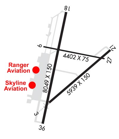
| Rwy | Rwy | |||||||
| 5940x150 | 5940' | 109.70 - 038° | 5940x150 | 5940' | ||||
| 4406x75 | 4406' | 4406x75 | 4406' | |||||
| 8054x150 | 7152' | 8054x150 | 8054' | |||||
| Runway ID | Single Wheel | Double Wheel | Double Tandem Wheel | Dual Double Wheel |
| 03/21 | 70,000 | 100,000 | N/A | N/A |
| 09/27 | 70,000 | 100,000 | N/A | N/A |
| 18/36 | 70,000 | 100,000 | N/A | N/A |
| These numbers are Advisory and are not limits. The Airport Manager should have more accurate Weight Limits | ||||
 Airport Diagram might not be current. | |
| Facility Name: | SAN ANGELO RGNL/MATHIS FLD |
| City Name: | SAN ANGELO |
| County: | TOM GREEN |
| State abbrev: | TX |
| State Name: | TEXAS |
| Ownership: | PUBLICLY OWNED |
| Use: | OPEN TO THE PUBLIC |
| Owner's Name: | CITY OF SAN ANGELO |
| Address: | 72 W COLLEGE ST |
| SAN ANGELO, TX 76903 | |
| Owner's Phone: | 325-659-6409 |
| Manager's Name: | JUSTIN FLETCHER |
| Address: | 8618 TERMINAL DRIVE, SUITE 101 |
| SAN ANGELO, TX 76904 | |
| Phone: | 325-659-6409 |
| FAA Region: | SOUTHWEST |
| FAA Field Office: | TEX |

| Date | Sunrise | Sunset |
|---|---|---|
| 02/10/25 Monday | 7:28 | 18:25 |
| 02/11/25 Tuesday | 7:27 | 18:26 |
| 02/12/25 Wednesday | 7:26 | 18:27 |
| 02/13/25 Thursday | 7:26 | 18:27 |
| 02/14/25 Friday | 7:25 | 18:28 |
| 02/15/25 Saturday | 7:24 | 18:29 |
| 02/16/25 Sunday | 7:23 | 18:30 |
| 02/17/25 Monday | 7:22 | 18:31 |
| 02/18/25 Tuesday | 7:21 | 18:32 |
| 02/19/25 Wednesday | 7:20 | 18:32 |
| 02/20/25 Thursday | 7:19 | 18:33 |
| 02/21/25 Friday | 7:18 | 18:34 |
| 02/22/25 Saturday | 7:17 | 18:35 |
| 02/23/25 Sunday | 7:16 | 18:36 |
| Airport Attendance Schedule | 7 Days A Week 0600-2200 |
| Airport Status | OPERATIONAL (This Status can change at any time - please check NOTAMS) |
| Airport Lighting Schedule | DUSK-DAWN. WHEN ATCT CLSD MIRL RWY 18/36 PRESET LOW INTST. TO INCR INTST & ACTVT MALSR RWY 03; REIL RWY 18; PAPI RWYS 18 & 36; HIRL RWY 03/21; MIRL RWY 09/27 - CTAF. |
| Airport Storage Available | Tie Downs, Hanger |
| Extra Services Available | Air Freight, Air Ambulance, Avionics, Charter, Flight Instruction, Aircraft Rental, Aircraft Sales |
| Wind Indicator | YES - (lighted) |
| Control Tower | YES |
| CTAF Frequency | 118.300 |
| Unicom Frequency | 122.950 |
| Rotating Beacon Color | WG |
| Segmented Circle | YES |
| Landing Fee | YES |
| Airport Inspected | FEDERAL - performed by FAA AIRPORTS FIELD PERSONNEL |
| Inspection Date | 12/19/2024 |
| Type of Fuel Available | Grade 100LL, JET A (freeze point -40C); -10FEE FOR FUEL AFT HRS CALL 325-656-1836/1837. |
| Airframe Repair Service | MAJOR |
| Power Plant Repair Service | MAJOR |
| Latitude | N3121.5 |
| Longitude | W10029.8 (ESTIMATED) |
| Arpt Elevation | 1918ft (SURVEYED) |
| Magnetic Variation | 05E |
| 7 miles SW | of SAN ANGELO |
| Traffic Pattern Altitude | |
| Sectional Chart | SAN ANTONIO |
| Operations (Reported) | Yearly | Avg. Daily |
|---|---|---|
| General Aviation Transient | 0 | 0 |
| General Aviation Local | 0 | 0 |
| Air Taxi | 0 | 0 |
| Commerical | 0 | 0 |
| Commuter | 0 | 0 |
| Military | 0 | 0 |
| Aircraft based on Field | |
|---|---|
| General Aviation Singles | 0 |
| General Aviation Multi | 0 |
| Jet Aircraft | 0 |
| General Aviation Helicopters | 0 |
| Military Aircraft | 0 |
| Gliders | 0 |
| Ultralights | 0 |
| FSS on field | NO |
| FSS tie-in | SAN ANGELO |
| FSS Phone | 1-800-WX-BRIEF |
| Who issues Notams | SJT |
| Notam D service at airport | YES |
| ARTCC Name | FORT WORTH |
| Airport Certification | AIRPORT RECEIVING SCHEDULED AIR CARRIER SERVICE FROM CARRIERS CERTIFICATED BY THE CIVIL AERONAUTICS BOARD; PPR 12 HRS FOR UNSKED ACR OPNS WITH OVER 30 PSGR SEATS CALL AMGR 325-659-6409. |
| Aircraft Rescue & Firefighting Index | AIRPORT HAS A CERTIFICATE UNDER CFR PART 139 |
| Airport of Entry | No |
| Custom Landing Rights | No |
| Joint Civil/Military | No |
| Military Landing rights | YES |
| NATIONAL PLAN OF INTEGRATED AIRPORT SYSTEMS (NPIAS) |
| GRANT AGREEMENTS UNDER FAAP/ADAP/AIP |
| SURPLUS PROPERTY AGREEMENT UNDER PUBLIC LAW 289 |
| ASSURANCES PURSUANT TO TITLE VI, CIVIL RIGHTS ACT OF 1964 |
| FOR CD IF UNA TO CTC ON FSS FREQ, CTC FORT WORTH ARTCC AT 817-858-7584. |
| RWY 09/2 7 RWY SLATED FOR CLOSURE |
Airport Communications & Frequencies:
| |||||||||||||||||||||||||||||||||
| Runway: 03 | Runway: 21 | ||
| Mag heading: | 38° | Mag heading: | 218° |
| Rwy Slope: | -.39% Down | Rwy Slope: | .39% Up |
| Approach: | ILS/DME | Approach: | |
| Pattern: | Left Traffic | Pattern: | Left Traffic |
| Markings: | PRECISION INSTRUMENT | Markings: | PRECISION INSTRUMENT |
| Marking Condition: | GOOD | Marking Condition: | GOOD |
| Arresting Dev: | Arresting Dev: | ||
| Lat & Long: | N3121.0 W10030.0 | Lat. & Long.: | N3121.7 W10029.2 |
| Elev: | 1916.4 ft. MSL | Elev: | 1893.0 ft. MSL |
| TCH: | TCH: | 52 ft. AGL | |
| Visual Glide Path: | Visual Glide Path: | 3.00 degrees | |
| Displaced Threshold: | No | Displaced Threshold: | No |
| Touchdown Zone: | YES | Touchdown Zone: | YES |
| Touchdown Elev.: | 1916.6 feet | Touchdown Elev.: | 1906.3 feet |
| Visual Glide Slope: | Visual Glide Slope: | 4-BOX VASI ON LEFT SIDE OF RUNWAY | |
| RVR Equipment: | TOUCHDOWN | RVR Equipment: | ROLLOUT |
| RVV Equipment: | YES | RVV Equipment: | NO |
| Approach Lights: | MALSR - 1,400 foot medium intensity approach lighting system with runway alignment indicator lights | Approach Lights: | |
| REIL: | NO | REIL: | NO |
| Centerline Lights: | NO | Centerline Lights: | NO |
| Touchdown lights: | NO | Touchdown lights: | NO |
| Runway Category: | Precision Instrument Runway | Runway Category: | D |
| Declared Distances: | TORA:5940' TODA:5940' ASDA:5940' LDA:5940' | Declared Distances: | TORA:5940' TODA:5940' ASDA:5940' LDA:5940' |
| Runway: 09 | Runway: 27 | ||
| Mag heading: | 92° | Mag heading: | 272° |
| Rwy Slope: | -.09% Down | Rwy Slope: | .09% Up |
| Approach: | Approach: | ||
| Pattern: | Left Traffic | Pattern: | Left Traffic |
| Markings: | BASIC | Markings: | BASIC |
| Marking Condition: | GOOD | Marking Condition: | GOOD |
| Arresting Dev: | Arresting Dev: | ||
| Lat & Long: | N3121.7 W10030.1 | Lat. & Long.: | N3121.6 W10029.3 |
| Elev: | 1902.3 ft. MSL | Elev: | 1898.4 ft. MSL |
| TCH: | TCH: | ||
| Visual Glide Path: | Visual Glide Path: | ||
| Displaced Threshold: | No | Displaced Threshold: | No |
| Touchdown Zone: | YES | Touchdown Zone: | YES |
| Touchdown Elev.: | 1905.9 feet | Touchdown Elev.: | 1904.5 feet |
| Visual Glide Slope: | Visual Glide Slope: | ||
| RVR Equipment: | RVR Equipment: | ||
| RVV Equipment: | NO | RVV Equipment: | NO |
| Approach Lights: | Approach Lights: | ||
| REIL: | NO | REIL: | NO |
| Centerline Lights: | NO | Centerline Lights: | NO |
| Touchdown lights: | NO | Touchdown lights: | NO |
| Runway Category: | Runway with a Visual Approach | Runway Category: | Runway with a Visual Approach |
| Declared Distances: | TORA:4406' TODA:4406' ASDA:4406' LDA:4406' | Declared Distances: | TORA:4406' TODA:4406' ASDA:4406' LDA:4406' |
| Obstructions: | ROAD | Obstructions: | ROAD |
| Marked: | NOT Marked/Lighted | Marked: | NOT Marked/Lighted |
| Clearance slope: | 25:1 | Clearance slope: | 36:1 |
| Obstruction height: | 13 feet AGL | Obstruction height: | 12 feet AGL |
| Dist. from runway: | 529 feet | Dist. from runway: | 633 feet |
| Centerline offset: | Centerline offset: | ||
| Comments: | Comments: |
| Runway: 18 | Runway: 36 | ||
| Mag heading: | 182° | Mag heading: | 2° |
| Rwy Slope: | .27% Up | Rwy Slope: | -.27% Down |
| Approach: | Approach: | ||
| Pattern: | Left Traffic | Pattern: | Left Traffic |
| Markings: | NONPRECISION INSTRUMENT | Markings: | NONPRECISION INSTRUMENT |
| Marking Condition: | GOOD | Marking Condition: | GOOD |
| Arresting Dev: | Arresting Dev: | ||
| Lat & Long: | N3122.1 W10029.9 | Lat. & Long.: | N3120.8 W10030.0 |
| Elev: | 1896.9 ft. MSL | Elev: | 1918.6 ft. MSL |
| TCH: | 45 ft. AGL | TCH: | 48 ft. AGL |
| Visual Glide Path: | 3.00 degrees | Visual Glide Path: | 3.00 degrees |
| Displaced Threshold: | 902 feet | Displaced Threshold: | No |
| Touchdown Zone: | YES | Touchdown Zone: | YES |
| Touchdown Elev.: | 1907.7 feet | Touchdown Elev.: | 1918.6 feet |
| Visual Glide Slope: | 4-Light PAPI on LEFT side of Runway | Visual Glide Slope: | 4-Light PAPI on LEFT side of Runway |
| RVR Equipment: | RVR Equipment: | ||
| RVV Equipment: | NO | RVV Equipment: | NO |
| Approach Lights: | Approach Lights: | ||
| REIL: | YES | REIL: | NO |
| Centerline Lights: | NO | Centerline Lights: | NO |
| Touchdown lights: | NO | Touchdown lights: | NO |
| Runway Category: | Runway with a Non-precision Approach having visibility minimums greater than 3/4 mile | Runway Category: | Runway with a Non-precision Approach having visibility minimums greater than 3/4 mile |
| Declared Distances: | TORA:8054' TODA:8054' ASDA:8054' LDA:7152' | Declared Distances: | TORA:7152' TODA:7152' ASDA:7152' LDA:7152' |
| Obstructions: | ROAD | Obstructions: | |
| Marked: | NOT Marked/Lighted | Marked: | |
| Clearance slope: | 30:1; APCH RATIO 50+:1 TO DSPLCD THR. | Clearance slope: | 50:1 |
| Obstruction height: | 6 feet AGL | Obstruction height: | |
| Dist. from runway: | 380 feet; ROAD 270 FT RIGHT AT CONTROLLING POINT RWY 18. | Dist. from runway: | |
| Centerline offset: | 270 right of centerline | Centerline offset: | |
| Comments: | Comments: |
Thanks for using FltPlan.com
all rights reserved © 1999-2025 by Flight Plan LLC