| SCHUYLKILL COUNTY /JOE ZERBEY/ POTTSVILLE PA |
| |
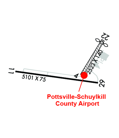
| Lat: N 4042.4 Long: W 07622.4 Elev: 1730 Var: +12 Longest Runway: 5101 | ||
| AWOS: 127.57 CTAF: 123.07 | ||
| ||||||||||||||||||||||||||||||
| ||||||||||||||||||||||||||||||
| ||||||||||||||||||||||||||||||
| Rwy | Rwy | |||||||
| 2523x140 | 2523' | 2523x140 | 2323' | |||||
| 5101x75 | 5101' | 5101x75 | 5101' | |||||
| Runway ID | Single Wheel | Double Wheel | Double Tandem Wheel | Dual Double Wheel |
| 04/22 | N/A | N/A | N/A | N/A |
| 11/29 | 21,000 | N/A | N/A | N/A |
| These numbers are Advisory and are not limits. The Airport Manager should have more accurate Weight Limits | ||||
 Airport Diagram might not be current. | |
| Facility Name: | SCHUYLKILL COUNTY/JOE ZERBEY |
| City Name: | POTTSVILLE |
| County: | SCHUYLKILL |
| State abbrev: | PA |
| State Name: | PENNSYLVANIA |
| Ownership: | PUBLICLY OWNED |
| Use: | OPEN TO THE PUBLIC |
| Owner's Name: | SCHUYLKILL COUNTY A/P AUTH |
| Address: | 240 AIRPORT ROAD |
| POTTSVILLE, PA 17901 | |
| Owner's Phone: | 570-544-6002 |
| Manager's Name: | BILL WILLARD |
| Address: | 240 AIRPORT ROAD |
| POTTSVILLE, PA 17901 | |
| Phone: | (570) 617-6002 |
| FAA Region: | EASTERN |
| FAA Field Office: | HAR |
| Date | Sunrise | Sunset |
|---|---|---|
| 03/15/25 Saturday | 7:18 | 19:12 |
| 03/16/25 Sunday | 7:16 | 19:13 |
| 03/17/25 Monday | 7:14 | 19:14 |
| 03/18/25 Tuesday | 7:13 | 19:15 |
| 03/19/25 Wednesday | 7:11 | 19:16 |
| 03/20/25 Thursday | 7:09 | 19:17 |
| 03/21/25 Friday | 7:08 | 19:18 |
| 03/22/25 Saturday | 7:06 | 19:20 |
| 03/23/25 Sunday | 7:04 | 19:21 |
| 03/24/25 Monday | 7:03 | 19:22 |
| 03/25/25 Tuesday | 7:01 | 19:23 |
| 03/26/25 Wednesday | 6:59 | 19:24 |
| 03/27/25 Thursday | 6:58 | 19:25 |
| 03/28/25 Friday | 6:56 | 19:26 |
| Airport Attendance Schedule | MON-FRI 0730-1700, SAT - SUN ON CALL; FOR SVC AFTER HRS 570-617-6002. |
| Airport Status | OPERATIONAL (This Status can change at any time - please check NOTAMS) |
| Airport Lighting Schedule | ACTIVATE REIL RWY 11 & 29; MIRL RWY 11/29 - CTAF. PAPI RWY 11 & 29 ON CONTINUOUSLY. |
| Airport Storage Available | Tie Downs, Hanger |
| Extra Services Available | Flight Instruction |
| Wind Indicator | YES - (lighted) |
| Control Tower | NO |
| CTAF Frequency | 123.075 |
| Unicom Frequency | 123.075 |
| Rotating Beacon Color | WG |
| Segmented Circle | NO |
| Landing Fee | NO |
| Airport Inspected | STATE - performed by STATE AERONAUTICAL PERSONNEL |
| Inspection Date | 03/20/2024 |
| Type of Fuel Available | Grade 100LL, JET A (freeze point -40C); -10AVGAS SELF SERVE WITH CREDIT CARD.; -A JET-A SELF-SERVE WITH CREDIT CARD. |
| Airframe Repair Service | MINOR |
| Power Plant Repair Service | MINOR |
| Latitude | N4042.4 |
| Longitude | W07622.4 (ESTIMATED) |
| Arpt Elevation | 1729ft (SURVEYED) |
| Magnetic Variation | 12W |
| 8 miles W | of POTTSVILLE |
| Traffic Pattern Altitude | |
| Sectional Chart | NEW YORK |
| Operations (Reported) | Yearly | Avg. Daily |
|---|---|---|
| General Aviation Transient | 0 | 0 |
| General Aviation Local | 0 | 0 |
| Air Taxi | 0 | 0 |
| Commerical | 0 | 0 |
| Commuter | 0 | 0 |
| Military | 0 | 0 |
| Aircraft based on Field | |
|---|---|
| General Aviation Singles | 0 |
| General Aviation Multi | 0 |
| Jet Aircraft | 0 |
| General Aviation Helicopters | 0 |
| Military Aircraft | 0 |
| Gliders | 0 |
| Ultralights | 0 |
| FSS on field | NO |
| FSS tie-in | WILLIAMSPORT |
| FSS Phone | 1-800-WX-BRIEF |
| Who issues Notams | IPT |
| Notam D service at airport | YES |
| ARTCC Name | NEW YORK |
| Airport Certification | |
| Aircraft Rescue & Firefighting Index | None |
| Airport of Entry | No |
| Custom Landing Rights | No |
| Joint Civil/Military | No |
| Military Landing rights | YES |
| NATIONAL PLAN OF INTEGRATED AIRPORT SYSTEMS (NPIAS) |
| GRANT AGREEMENTS UNDER FAAP/ADAP/AIP |
| ASSURANCES PURSUANT TO TITLE VI, CIVIL RIGHTS ACT OF 1964 |
| DEER ON & INVOF ARPT. |
| FOR CD CTC HARRISBURG APCH AT 800-932-0712. |
| GPU AVAILABLE FOR AC/DC POWER. |
| RWY 04/2 2 NOT MAINTAINED WINTER MONTHS. |
Airport Communications & Frequencies:
| ||||||||||||||
| Runway: 04 | Runway: 22 | ||
| Mag heading: | 43° | Mag heading: | 223° |
| Rwy Slope: | .41% Up | Rwy Slope: | -.41% Down |
| Approach: | Approach: | ||
| Pattern: | Left Traffic | Pattern: | Left Traffic |
| Markings: | NONE | Markings: | NONE |
| Marking Condition: | POOR; RY 04/22 EDGE & DSPLCD THLD MKD WITH ORANGE CONES. | Marking Condition: | POOR |
| Arresting Dev: | Arresting Dev: | ||
| Lat & Long: | N4042.4 W07622.2 | Lat. & Long.: | N4042.7 W07622.0 |
| Elev: | 1708.1 ft. MSL | Elev: | 1718.4 ft. MSL |
| TCH: | TCH: | ||
| Visual Glide Path: | Visual Glide Path: | ||
| Displaced Threshold: | No | Displaced Threshold: | 200 feet |
| Touchdown Zone: | YES | Touchdown Zone: | YES |
| Touchdown Elev.: | 1718.4 feet | Touchdown Elev.: | 1715.8 feet |
| Visual Glide Slope: | Visual Glide Slope: | ||
| RVR Equipment: | RVR Equipment: | ||
| RVV Equipment: | NO | RVV Equipment: | NO |
| Approach Lights: | Approach Lights: | ||
| REIL: | NO | REIL: | NO |
| Centerline Lights: | NO | Centerline Lights: | NO |
| Touchdown lights: | NO | Touchdown lights: | NO |
| Runway Category: | Runway with a Visual Approach | Runway Category: | Runway with a Visual Approach |
| Declared Distances: | Declared Distances: | ||
| Obstructions: | Obstructions: | TREES | |
| Marked: | Marked: | NOT Marked/Lighted | |
| Clearance slope: | 20:1 | Clearance slope: | 12:1; APCH RATIO 19:1 TO DTHR. |
| Obstruction height: | Obstruction height: | 27 feet AGL | |
| Dist. from runway: | Dist. from runway: | 320 feet | |
| Centerline offset: | Centerline offset: | 110 feet right of centerline | |
| Comments: | Comments: |
| Runway: 11 | Runway: 29 | ||
| Mag heading: | 110° | Mag heading: | 290° |
| Rwy Slope: | -.45% Down | Rwy Slope: | .45% Up |
| Approach: | Approach: | ||
| Pattern: | Left Traffic | Pattern: | Left Traffic |
| Markings: | NONPRECISION INSTRUMENT | Markings: | NONPRECISION INSTRUMENT |
| Marking Condition: | GOOD | Marking Condition: | GOOD |
| Arresting Dev: | Arresting Dev: | ||
| Lat & Long: | N4042.4 W07623.1 | Lat. & Long.: | N4042.3 W07622.0 |
| Elev: | 1729.7 ft. MSL | Elev: | 1706.5 ft. MSL |
| TCH: | 40 ft. AGL | TCH: | 45 ft. AGL |
| Visual Glide Path: | 3.00 degrees | Visual Glide Path: | 3.00 degrees |
| Displaced Threshold: | No | Displaced Threshold: | No |
| Touchdown Zone: | YES | Touchdown Zone: | YES |
| Touchdown Elev.: | 1729.8 feet | Touchdown Elev.: | 1723.8 feet |
| Visual Glide Slope: | 2-Light PAPI on LEFT side of Runway | Visual Glide Slope: | 2-Light PAPI on LEFT side of Runway |
| RVR Equipment: | RVR Equipment: | ||
| RVV Equipment: | NO | RVV Equipment: | NO |
| Approach Lights: | Approach Lights: | ||
| REIL: | YES | REIL: | YES |
| Centerline Lights: | NO | Centerline Lights: | NO |
| Touchdown lights: | NO | Touchdown lights: | NO |
| Runway Category: | D | Runway Category: | D |
| Declared Distances: | Declared Distances: | ||
| Obstructions: | TREES | Obstructions: | TREES |
| Marked: | NOT Marked/Lighted | Marked: | NOT Marked/Lighted |
| Clearance slope: | 9:1 | Clearance slope: | 3:1 |
| Obstruction height: | 31 feet AGL | Obstruction height: | 21 feet AGL |
| Dist. from runway: | 482 feet | Dist. from runway: | 265 feet |
| Centerline offset: | 535 right of centerline | Centerline offset: | 393 feet right of centerline |
| Comments: | Comments: |
Thanks for using FltPlan.com
all rights reserved © 1999-2025 by Flight Plan LLC