
| GREATER CUMBERLAND RGNL CUMBERLAND MD |
| |
| Lat: N 3936.9 Long: W 07845.7 Elev: 775 Var: +10 Longest Runway: 5047 | ||
| AWOS: 128.62 CTAF: 122.8 | ||
| ||||||||||||||||||||||||||||||||||||||||||||
| ||||||||||||||||||||||||||||||||||||||||||||
| ||||||||||||||||||||||||||||||||||||||||||||
| Rwy | Rwy | |||||||
| 5047x150 | 5047' | 5047x150 | 5047' | 110.50 - 227° | ||||
| 3000x150 | 2440' | 3000x150 | 3000' | |||||
| Runway ID | Single Wheel | Double Wheel | Double Tandem Wheel | Dual Double Wheel |
| 05/23 | 38,000 | 52,000 | N/A | N/A |
| 11/29 | 12,000 | N/A | N/A | N/A |
| These numbers are Advisory and are not limits. The Airport Manager should have more accurate Weight Limits | ||||
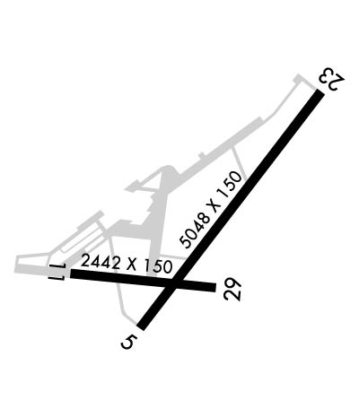 Airport Diagram might not be current. | |
| Facility Name: | GREATER CUMBERLAND RGNL |
| City Name: | CUMBERLAND |
| County: | MINERAL; COUNTY LOCATED IN WV. |
| State abbrev: | MD |
| State Name: | MARYLAND |
| Ownership: | PUBLICLY OWNED |
| Use: | OPEN TO THE PUBLIC |
| Owner's Name: | POTOMAC HIGHLAND ARPT AUTH |
| Address: | 165 TERMINAL LOOP |
| WILEY FORD, WV 26767 | |
| Owner's Phone: | 304-738-0002 |
| Manager's Name: | RYAN SHAFFER |
| Address: | 165 TERMINAL LOOP |
| WILEY FORD, WV 26767 | |
| Phone: | 304-738-0002 |
| FAA Region: | EASTERN |
| FAA Field Office: | DCA |
| Date | Sunrise | Sunset |
|---|---|---|
| 09/24/21 Friday | 7:04 | 19:09 |
| 09/25/21 Saturday | 7:05 | 19:08 |
| 09/26/21 Sunday | 7:06 | 19:06 |
| 09/27/21 Monday | 7:07 | 19:04 |
| 09/28/21 Tuesday | 7:08 | 19:03 |
| 09/29/21 Wednesday | 7:09 | 19:01 |
| 09/30/21 Thursday | 7:10 | 19:00 |
| 10/01/21 Friday | 7:11 | 18:58 |
| 10/02/21 Saturday | 7:12 | 18:56 |
| 10/03/21 Sunday | 7:13 | 18:55 |
| 10/04/21 Monday | 7:14 | 18:53 |
| 10/05/21 Tuesday | 7:15 | 18:52 |
| 10/06/21 Wednesday | 7:16 | 18:50 |
| 10/07/21 Thursday | 7:17 | 18:48 |
| Airport Attendance Schedule | 7 Days A Week 0800-2000 |
| Airport Status | OPERATIONAL (This Status can change at any time - please check NOTAMS) |
| Airport Lighting Schedule | ACTVT HIRL RY 05/23; LIRL RY 11/29; REIL RY 23 & TWY LGTS - CTAF. |
| Airport Storage Available | Tie Downs, Hanger |
| Extra Services Available | Air Freight, Cargo Handling, Glider, Flight Instruction, Glider Towing |
| Wind Indicator | YES - (lighted) |
| Control Tower | NO |
| CTAF Frequency | 122.800 |
| Unicom Frequency | 122.800 |
| Rotating Beacon Color | CLEAR-GREEN (Light Land Airport); ROTG BCN LOCATED OFF ARPT. |
| Segmented Circle | YES |
| Landing Fee | NO |
| Airport Inspected | STATE - performed by STATE AERONAUTICAL PERSONNEL |
| Inspection Date | 08/11/2020 |
| Type of Fuel Available | Grade 100LL, JET A (freeze point -40C) |
| Airframe Repair Service | MAJOR |
| Power Plant Repair Service | MAJOR |
| Latitude | N3936.9 |
| Longitude | W07845.7 (ESTIMATED) |
| Arpt Elevation | 775ft (SURVEYED) |
| Magnetic Variation | 10W |
| 2 miles S | of CUMBERLAND |
| Traffic Pattern Altitude | 1024 |
| Sectional Chart | WASHINGTON |
| Operations (Reported) | Yearly | Avg. Daily |
|---|---|---|
| General Aviation Transient | 2500 | 7 |
| General Aviation Local | 11500 | 32 |
| Air Taxi | 0 | 0 |
| Commerical | 0 | 0 |
| Commuter | 0 | 0 |
| Military | 300 | 1 |
| Aircraft based on Field | |
|---|---|
| General Aviation Singles | 47 |
| General Aviation Multi | 4 |
| Jet Aircraft | 0 |
| General Aviation Helicopters | 2 |
| Military Aircraft | 0 |
| Gliders | 5 |
| Ultralights | 0 |
| FSS on field | NO |
| FSS tie-in | ELKINS |
| FSS Phone | 1-800-WX-BRIEF |
| Who issues Notams | EKN |
| Notam D service at airport | YES |
| ARTCC Name | CLEVELAND |
| Airport Certification | |
| Aircraft Rescue & Firefighting Index | None |
| Airport of Entry | No |
| Custom Landing Rights | No |
| Joint Civil/Military | No |
| Military Landing rights | YES |
| NATIONAL PLAN OF INTEGRATED AIRPORT SYSTEMS (NPIAS) |
| GRANT AGREEMENTS UNDER FAAP/ADAP/AIP |
| ASSURANCES PURSUANT TO TITLE VI, CIVIL RIGHTS ACT OF 1964 |
| AGREEMENT UNDER DLAND OR DCLA HAS EXPIRED. |
| RWY 11 NGT OPNS & ANY LNDGS NOT RECOMMENDED DUE TO HIGH TERRAIN. |
| GLIDER OPNS W OF ARPT USE RWY 11 FOR DEP; RWY 29 FOR ARR. |
| DEER/BIRDS ON & INVOF ARPT. |
| RWY 23 900 FT TAXIWAY ALIGNED WITH RWY WEST END. |
| RWY 05 APCH HAS RAPIDLY RISING TERRAIN 696 FT L, 2000 FT FM THLD. |
| FOR CD CTC JOHNSTOWN APCH AT 814-532-5960, WHEN APCH CLSD CTC CLEVELAND ARTCC AT 440-774-0234. |
| COLD TEMPERATURE AIRPORT. ALTITUDE CORRECTION REQUIRED AT OR BELOW -15C. |
| RWY 11/2 9 NSTD LIRL FM RWY 11 THR TO RWY 11 DSPLCD THR, DUE TO IMPROPER LENS COLORS AND SPACING. |
Airport Communications & Frequencies:
| |||||||||||||||||
| Runway: 05 | Runway: 23 | ||
| Mag heading: | 49° | Mag heading: | 229° |
| Rwy Slope: | 1.05% Up | Rwy Slope: | -1.05% Down |
| Approach: | Approach: | LOC/DME | |
| Pattern: | Right Traffic | Pattern: | Left Traffic |
| Markings: | NONPRECISION INSTRUMENT | Markings: | PRECISION INSTRUMENT |
| Marking Condition: | POOR; RWY 05/23 MARKINGS & CL PARTIALLY OBSCURED BY LONGITUDINAL AND TRANSVERSE CRACK FILL. RWY 5/23 MARKINGS FADED. | Marking Condition: | POOR |
| Arresting Dev: | Arresting Dev: | ||
| Lat & Long: | N3936.7 W07845.9 | Lat. & Long.: | N3937.3 W07845.2 |
| Elev: | 721.9 ft. MSL | Elev: | 775.0 ft. MSL |
| TCH: | TCH: | 29 ft. AGL | |
| Visual Glide Path: | Visual Glide Path: | 3.59 degrees | |
| Displaced Threshold: | No | Displaced Threshold: | No |
| Touchdown Zone: | YES | Touchdown Zone: | YES |
| Touchdown Elev.: | 746.2 feet | Touchdown Elev.: | 775.0 feet |
| Visual Glide Slope: | Visual Glide Slope: | 4-Light PAPI on LEFT side of Runway | |
| RVR Equipment: | RVR Equipment: | ||
| RVV Equipment: | NO | RVV Equipment: | NO |
| Approach Lights: | Approach Lights: | ||
| REIL: | NO | REIL: | YES |
| Centerline Lights: | NO | Centerline Lights: | NO |
| Touchdown lights: | NO | Touchdown lights: | NO |
| Runway Category: | Runway with a Visual Approach | Runway Category: | Runway with a Non-precision Approach having visibility minimums greater than 3/4 mile |
| Declared Distances: | Declared Distances: | ||
| Obstructions: | TREES | Obstructions: | |
| Marked: | NOT Marked/Lighted | Marked: | |
| Clearance slope: | 13:1 | Clearance slope: | 50:1 |
| Obstruction height: | 8 feet AGL | Obstruction height: | |
| Dist. from runway: | 310 feet | Dist. from runway: | |
| Centerline offset: | Centerline offset: | ||
| Comments: | Comments: |
| Runway: 11 | Runway: 29 | ||
| Mag heading: | 107° | Mag heading: | 287° |
| Rwy Slope: | .19% Up | Rwy Slope: | -.19% Down |
| Approach: | Approach: | ||
| Pattern: | Left Traffic | Pattern: | Left Traffic |
| Markings: | BASIC | Markings: | NONPRECISION INSTRUMENT |
| Marking Condition: | FAIR | Marking Condition: | FAIR |
| Arresting Dev: | Arresting Dev: | ||
| Lat & Long: | N3936.8 W07846.2 | Lat. & Long.: | N3936.8 W07845.6 |
| Elev: | 721.2 ft. MSL | Elev: | 727.0 ft. MSL |
| TCH: | TCH: | ||
| Visual Glide Path: | Visual Glide Path: | ||
| Displaced Threshold: | 560 feet | Displaced Threshold: | No |
| Touchdown Zone: | YES | Touchdown Zone: | YES |
| Touchdown Elev.: | 727.0 feet | Touchdown Elev.: | 727.0 feet |
| Visual Glide Slope: | Visual Glide Slope: | ||
| RVR Equipment: | RVR Equipment: | ||
| RVV Equipment: | NO | RVV Equipment: | NO |
| Approach Lights: | Approach Lights: | ||
| REIL: | NO | REIL: | NO |
| Centerline Lights: | NO | Centerline Lights: | NO |
| Touchdown lights: | NO | Touchdown lights: | NO |
| Runway Category: | Runway with a Visual Approach | Runway Category: | Runway with a Visual Approach |
| Declared Distances: | Declared Distances: | ||
| Obstructions: | HILL | Obstructions: | TREE |
| Marked: | NOT Marked/Lighted | Marked: | NOT Marked/Lighted |
| Clearance slope: | 5:1 | Clearance slope: | 19:1 |
| Obstruction height: | 632 feet AGL | Obstruction height: | 10 feet AGL |
| Dist. from runway: | 3951 feet | Dist. from runway: | 395 feet |
| Centerline offset: | Centerline offset: | 87 feet left of centerline | |
| Comments: | Comments: |
Thanks for using FltPlan.com
all rights reserved © 1999-2021 by Flight Plan LLC
