
| WILMINGTON INTL WILMINGTON NC |
| |
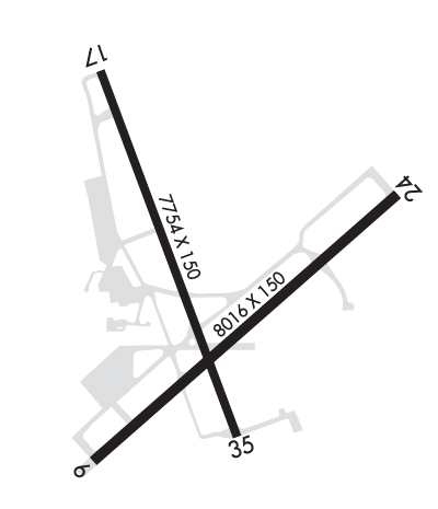
| Lat: N 3416.3 Long: W 07754.2 Elev: 32 Var: +10 Longest Runway: 8016 | ||
| Dept. ATIS: 124.97 Arr. ATIS: 124.97 Ground: 121.9 Tower: 119.9 | ||
| ||||||||||||||||||||||||||||||||||||||||||||
| ||||||||||||||||||||||||||||||||||||||||||||
| ||||||||||||||||||||||||||||||||||||||||||||
| Rwy | Rwy | |||||||
| 8016x150 | 8016' | 109.95 - 058° | 8016x150 | 8016' | 111.55 - 238° | |||
| 7754x150 | 7404' | 7754x150 | 7354' | 110.30 - 349° | ||||
| Runway ID | Single Wheel | Double Wheel | Double Tandem Wheel | Dual Double Wheel |
| 06/24 | 75,000 | 160,000 | 275,000 | N/A |
| 17/35 | 60,000 | 185,000 | 300,000 | N/A |
| These numbers are Advisory and are not limits. The Airport Manager should have more accurate Weight Limits | ||||
 Airport Diagram might not be current. | |
| Facility Name: | WILMINGTON INTL |
| City Name: | WILMINGTON |
| County: | NEW HANOVER |
| State abbrev: | NC |
| State Name: | NORTH CAROLINA |
| Ownership: | PUBLICLY OWNED |
| Use: | OPEN TO THE PUBLIC |
| Owner's Name: | NEW HANOVER COUNTY |
| Address: | 1740 AIRPORT BLVD |
| WILMINGTON, NC 28405 | |
| Owner's Phone: | 910-341-4333 |
| Manager's Name: | JULIE WILSEY |
| Address: | 1740 AIRPORT BLVD |
| WILMINGTON, NC 28405 | |
| Phone: | 910-341-4333; EXT 1001. |
| FAA Region: | SOUTHERN |
| FAA Field Office: | MEM |
| Date | Sunrise | Sunset |
|---|---|---|
| 09/24/21 Friday | 7:01 | 19:06 |
| 09/25/21 Saturday | 7:02 | 19:04 |
| 09/26/21 Sunday | 7:02 | 19:03 |
| 09/27/21 Monday | 7:03 | 19:02 |
| 09/28/21 Tuesday | 7:04 | 19:00 |
| 09/29/21 Wednesday | 7:04 | 18:59 |
| 09/30/21 Thursday | 7:05 | 18:58 |
| 10/01/21 Friday | 7:06 | 18:56 |
| 10/02/21 Saturday | 7:07 | 18:55 |
| 10/03/21 Sunday | 7:07 | 18:53 |
| 10/04/21 Monday | 7:08 | 18:52 |
| 10/05/21 Tuesday | 7:09 | 18:51 |
| 10/06/21 Wednesday | 7:10 | 18:49 |
| 10/07/21 Thursday | 7:10 | 18:48 |
| Airport Attendance Schedule | CONTINUOUS |
| Airport Status | OPERATIONAL (This Status can change at any time - please check NOTAMS) |
| Airport Lighting Schedule | ACTVT REIL RY 06, MALSR RY 24, HIRL RY 06/24, PAPI RY 06 AND 24, ALL TWY LGTS - CTAF. |
| Airport Storage Available | Tie Downs, Hanger |
| Extra Services Available | Air Freight, Cargo Handling, Charter, Flight Instruction, Aircraft Rental, Aircraft Sales |
| Wind Indicator | YES - (lighted) |
| Control Tower | YES |
| CTAF Frequency | 119.900 |
| Unicom Frequency | 122.950 |
| Rotating Beacon Color | CLEAR-GREEN (Light Land Airport) |
| Segmented Circle | NO |
| Landing Fee | NO |
| Airport Inspected | FEDERAL - performed by FAA AIRPORTS FIELD PERSONNEL |
| Inspection Date | 03/06/2020 |
| Type of Fuel Available | Grade 100LL, JET A (freeze point -40C), JET A |
| Airframe Repair Service | MAJOR |
| Power Plant Repair Service | MAJOR |
| Latitude | N3416.3 |
| Longitude | W07754.2 (ESTIMATED) |
| Arpt Elevation | 31ft (SURVEYED) |
| Magnetic Variation | 10W |
| 3 miles NE | of WILMINGTON |
| Traffic Pattern Altitude | |
| Sectional Chart | CHARLOTTE |
| Operations (Reported) | Yearly | Avg. Daily |
|---|---|---|
| General Aviation Transient | 25855 | 71 |
| General Aviation Local | 9283 | 25 |
| Air Taxi | 13912 | 38 |
| Commerical | 8626 | 24 |
| Commuter | 0 | 0 |
| Military | 11430 | 31 |
| Aircraft based on Field | |
|---|---|
| General Aviation Singles | 67 |
| General Aviation Multi | 11 |
| Jet Aircraft | 21 |
| General Aviation Helicopters | 8 |
| Military Aircraft | 0 |
| Gliders | 0 |
| Ultralights | 0 |
| FSS on field | NO |
| FSS tie-in | RALEIGH; FSS-RALEIGH RDU-NOTAM ILM |
| FSS Phone | 1-800-WX-BRIEF |
| Who issues Notams | ILM |
| Notam D service at airport | YES |
| ARTCC Name | WASHINGTON |
| Airport Certification | AIRPORT RECEIVING SCHEDULED AIR CARRIER SERVICE FROM CARRIERS CERTIFICATED BY THE CIVIL AERONAUTICS BOARD |
| Aircraft Rescue & Firefighting Index | AIRPORT HAS A CERTIFICATE UNDER CFR PART 139 |
| Airport of Entry | No |
| Custom Landing Rights | YES |
| Joint Civil/Military | No |
| Military Landing rights | YES |
| NATIONAL PLAN OF INTEGRATED AIRPORT SYSTEMS (NPIAS) |
| GRANT AGREEMENTS UNDER FAAP/ADAP/AIP |
| SURPLUS PROPERTY AGREEMENT UNDER PUBLIC LAW 289 |
| SURPLUS PROPERTY AGREEMENT UNDER REGULATION 16-WAA |
| ASSURANCES PURSUANT TO TITLE VI, CIVIL RIGHTS ACT OF 1964 |
| AGREEMENT UNDER DLAND OR DCLA HAS EXPIRED. |
| FUEL: AIR WILMINGTON, INC, 910-763-4691 |
| BEARING STRENGTH RWY 06-24: ST175 |
| BEARING STRENGTH RWY 17-35: ST175 |
| FOR CD IF UNA TO CTC ON FSS FREQ, CTC WASHINGTON ARTCC AT 703-771-3587. |
Airport Communications & Frequencies:
| |||||||||||||||||||||||||||||||||||||||||||
| Runway: 06 | Runway: 24 | ||
| Mag heading: | 58° | Mag heading: | 238° |
| Rwy Slope: | -.01% Down | Rwy Slope: | .01% Up |
| Approach: | ILS/DME | Approach: | ILS |
| Pattern: | Left Traffic | Pattern: | Left Traffic |
| Markings: | PRECISION INSTRUMENT | Markings: | PRECISION INSTRUMENT |
| Marking Condition: | GOOD | Marking Condition: | GOOD |
| Arresting Dev: | Arresting Dev: | ||
| Lat & Long: | N3415.7 W07754.6 | Lat. & Long.: | N3416.6 W07753.4 |
| Elev: | 21.0 ft. MSL | Elev: | 20.2 ft. MSL |
| TCH: | 57 ft. AGL | TCH: | 48 ft. AGL |
| Visual Glide Path: | 3.00 degrees | Visual Glide Path: | 3.00 degrees |
| Displaced Threshold: | No | Displaced Threshold: | No |
| Touchdown Zone: | YES | Touchdown Zone: | YES |
| Touchdown Elev.: | 28.0 feet | Touchdown Elev.: | 26.0 feet |
| Visual Glide Slope: | 4-Light PAPI on RIGHT side of Runway | Visual Glide Slope: | 4-Light PAPI on LEFT side of Runway |
| RVR Equipment: | TOUCHDOWN-ROLLOUT | RVR Equipment: | TOUCHDOWN-ROLLOUT |
| RVV Equipment: | NO | RVV Equipment: | NO |
| Approach Lights: | Approach Lights: | MALSR - 1,400 foot medium intensity approach lighting system with runway alignment indicator lights | |
| REIL: | YES | REIL: | NO |
| Centerline Lights: | NO | Centerline Lights: | NO |
| Touchdown lights: | NO | Touchdown lights: | NO |
| Runway Category: | Precision Instrument Runway | Runway Category: | Precision Instrument Runway |
| Declared Distances: | TORA:8016' TODA:8016' ASDA:8016' LDA:8016' | Declared Distances: | TORA:8016' TODA:8016' ASDA:8016' LDA:8016' |
| Runway: 17 | Runway: 35 | ||
| Mag heading: | 169° | Mag heading: | 349° |
| Rwy Slope: | -.16% Down | Rwy Slope: | .16% Up |
| Approach: | Approach: | ILS | |
| Pattern: | Left Traffic | Pattern: | Left Traffic |
| Markings: | PRECISION INSTRUMENT | Markings: | PRECISION INSTRUMENT |
| Marking Condition: | GOOD | Marking Condition: | GOOD |
| Arresting Dev: | Arresting Dev: | ||
| Lat & Long: | N3417.0 W07754.6 | Lat. & Long.: | N3415.8 W07754.1 |
| Elev: | 30.9 ft. MSL | Elev: | 18.3 ft. MSL |
| TCH: | 50 ft. AGL | TCH: | 36 ft. AGL |
| Visual Glide Path: | 3.00 degrees | Visual Glide Path: | 3.00 degrees |
| Displaced Threshold: | 350 feet | Displaced Threshold: | 400 feet |
| Touchdown Zone: | YES | Touchdown Zone: | YES |
| Touchdown Elev.: | 31.7 feet | Touchdown Elev.: | 30.7 feet |
| Visual Glide Slope: | 4-Light PAPI on LEFT side of Runway | Visual Glide Slope: | 4-Light PAPI on LEFT side of Runway |
| RVR Equipment: | ROLLOUT | RVR Equipment: | TOUCHDOWN |
| RVV Equipment: | NO | RVV Equipment: | NO |
| Approach Lights: | Approach Lights: | MALSR - 1,400 foot medium intensity approach lighting system with runway alignment indicator lights | |
| REIL: | YES | REIL: | NO |
| Centerline Lights: | NO | Centerline Lights: | NO |
| Touchdown lights: | NO | Touchdown lights: | NO |
| Runway Category: | Runway with a Non-precision Approach having visibility minimums greater than 3/4 mile | Runway Category: | Precision Instrument Runway |
| Declared Distances: | TORA:7754' TODA:7754' ASDA:6954' LDA:6604' | Declared Distances: | TORA:7754' TODA:7754' ASDA:7604' LDA:7204' |
Thanks for using FltPlan.com
all rights reserved © 1999-2021 by Flight Plan LLC
