| VALLEY INTL HARLINGEN TX |
| |
| Lat: N 2613.6 Long: W 09739.3 Elev: 36 Var: -05 Longest Runway: 8301 | ||
| Dept. ATIS: 124.85 Arr. ATIS: 124.85 Ground: 121.7 Tower: 119.3 | ||
| |||||||||||||||||||||||||||||||||||||||||||||||||||||||||||||||||||||
| |||||||||||||||||||||||||||||||||||||||||||||||||||||||||||||||||||||
| |||||||||||||||||||||||||||||||||||||||||||||||||||||||||||||||||||||
| |||||||||||||||||||||||||||||||||||||||||||||||||||||||||||||||||||||
| |||||||||||||||||||||||||||||||||||||||||||||||||||||||||||||||||||||
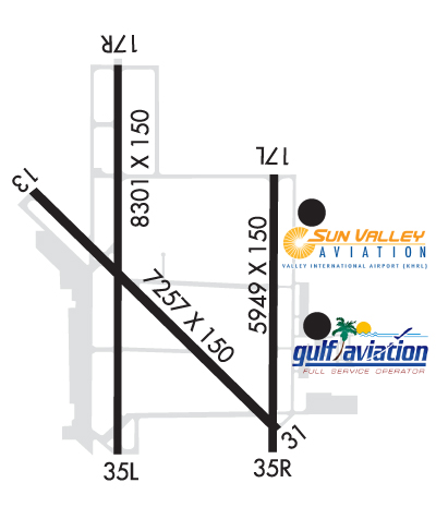
| Rwy | Rwy | |||||||
| 7257x150 | 7257' | 7257x150 | 7257' | |||||
| 5949x150 | 5949' | 5949x150 | 5759' | |||||
| 8301x150 | 8301' | 111.50 - 175° | 8301x150 | 8301' | ||||
| Runway ID | Single Wheel | Double Wheel | Double Tandem Wheel | Dual Double Wheel |
| 13/31 | 160,000 | 200,000 | 350,000 | 700,000 |
| 17L/35R | 160,000 | 200,000 | 350,000 | N/A |
| 17R/35L | 160,000 | 200,000 | 350,000 | 700,000 |
| These numbers are Advisory and are not limits. The Airport Manager should have more accurate Weight Limits | ||||
 Airport Diagram might not be current. | |
| Facility Name: | VALLEY INTL |
| City Name: | HARLINGEN |
| County: | CAMERON |
| State abbrev: | TX |
| State Name: | TEXAS |
| Ownership: | PUBLICLY OWNED |
| Use: | OPEN TO THE PUBLIC |
| Owner's Name: | CITY OF HARLINGEN |
| Address: | PO BOX 2207 |
| HARLINGEN, TX 78551-2207 | |
| Owner's Phone: | (956) 430-8605 |
| Manager's Name: | MARV ESTERLY |
| Address: | AIRPORT TERMINAL BUILDING,, 3200 HERITAGE WAY |
| HARLINGEN, TX 78550 | |
| Phone: | 956-430-8605 |
| FAA Region: | SOUTHWEST |
| FAA Field Office: | TEX |
| Date | Sunrise | Sunset |
|---|---|---|
| 09/24/21 Friday | 7:20 | 19:25 |
| 09/25/21 Saturday | 7:20 | 19:24 |
| 09/26/21 Sunday | 7:21 | 19:23 |
| 09/27/21 Monday | 7:21 | 19:22 |
| 09/28/21 Tuesday | 7:22 | 19:21 |
| 09/29/21 Wednesday | 7:22 | 19:19 |
| 09/30/21 Thursday | 7:22 | 19:18 |
| 10/01/21 Friday | 7:23 | 19:17 |
| 10/02/21 Saturday | 7:23 | 19:16 |
| 10/03/21 Sunday | 7:24 | 19:15 |
| 10/04/21 Monday | 7:24 | 19:14 |
| 10/05/21 Tuesday | 7:25 | 19:13 |
| 10/06/21 Wednesday | 7:25 | 19:12 |
| 10/07/21 Thursday | 7:26 | 19:11 |
| Airport Attendance Schedule | 7 Days A Week 0600-0000 |
| Airport Status | OPERATIONAL (This Status can change at any time - please check NOTAMS) |
| Airport Lighting Schedule | DUSK-DAWN. WHEN ATCT CLSD ACTVT MALSR RWY 17R AND RWY 31- CTAF. |
| Airport Storage Available | Tie Downs, Hanger |
| Extra Services Available | Air Freight, Avionics, Cargo Handling, Charter, Flight Instruction, Aircraft Rental, Aircraft Sales |
| Wind Indicator | YES - (lighted) |
| Control Tower | YES |
| CTAF Frequency | 119.300 |
| Unicom Frequency | 122.950 |
| Rotating Beacon Color | CLEAR-GREEN (Light Land Airport) |
| Segmented Circle | YES |
| Landing Fee | NO |
| Airport Inspected | FEDERAL - performed by FAA AIRPORTS FIELD PERSONNEL |
| Inspection Date | 05/13/2021 |
| Type of Fuel Available | Grade 100LL, JET A (freeze point -40C) |
| Airframe Repair Service | MAJOR |
| Power Plant Repair Service | MAJOR |
| Latitude | N2613.6 |
| Longitude | W09739.3 (ESTIMATED) |
| Arpt Elevation | 36ft (SURVEYED) |
| Magnetic Variation | 05E |
| 3 miles NE | of HARLINGEN |
| Traffic Pattern Altitude | |
| Sectional Chart | BROWNSVILLE |
| Operations (Reported) | Yearly | Avg. Daily |
|---|---|---|
| General Aviation Transient | 9030 | 25 |
| General Aviation Local | 6679 | 18 |
| Air Taxi | 1647 | 5 |
| Commerical | 7899 | 22 |
| Commuter | 0 | 0 |
| Military | 16672 | 46 |
| Aircraft based on Field | |
|---|---|
| General Aviation Singles | 44 |
| General Aviation Multi | 12 |
| Jet Aircraft | 2 |
| General Aviation Helicopters | 0 |
| Military Aircraft | 0 |
| Gliders | 0 |
| Ultralights | 0 |
| FSS on field | NO |
| FSS tie-in | SAN ANGELO |
| FSS Phone | 1-800-WX-BRIEF |
| Who issues Notams | HRL |
| Notam D service at airport | YES |
| ARTCC Name | HOUSTON |
| Airport Certification | AIRPORT RECEIVING SCHEDULED AIR CARRIER SERVICE FROM CARRIERS CERTIFICATED BY THE CIVIL AERONAUTICS BOARD |
| Aircraft Rescue & Firefighting Index | AIRPORT HAS A CERTIFICATE UNDER CFR PART 139 |
| Airport of Entry | No |
| Custom Landing Rights | YES; US CUSTOMS USER FEE ARPT. |
| Joint Civil/Military | No |
| Military Landing rights | YES |
| NATIONAL PLAN OF INTEGRATED AIRPORT SYSTEMS (NPIAS) |
| GRANT AGREEMENTS UNDER FAAP/ADAP/AIP |
| SURPLUS PROPERTY AGREEMENT UNDER PUBLIC LAW 289 |
| ASSURANCES PURSUANT TO TITLE VI, CIVIL RIGHTS ACT OF 1964 |
| AGREEMENT UNDER DLAND OR DCLA HAS EXPIRED. |
| MIGRATORY BIRDS ON & INVOF ARPT. |
| WHEN ATCT CLSD REQ ARFF THRU CORPUS APPROACH OR FLT SVC. |
| FOR CD WHEN ATCT IS CLSD CTC CRP APCH AT 361-299-4230. |
Airport Communications & Frequencies:
| ||||||||||||||||||||||||||
| Runway: 13 | Runway: 31 | ||
| Mag heading: | 131° | Mag heading: | 311° |
| Rwy Slope: | .02% Up | Rwy Slope: | -.02% Down |
| Approach: | Approach: | ||
| Pattern: | Left Traffic | Pattern: | Left Traffic |
| Markings: | PRECISION INSTRUMENT | Markings: | PRECISION INSTRUMENT |
| Marking Condition: | GOOD | Marking Condition: | GOOD |
| Arresting Dev: | Arresting Dev: | ||
| Lat & Long: | N2614.0 W09739.8 | Lat. & Long.: | N2613.1 W09738.9 |
| Elev: | 34.4 ft. MSL | Elev: | 35.7 ft. MSL |
| TCH: | 59 ft. AGL | TCH: | 55 ft. AGL |
| Visual Glide Path: | 3.00 degrees | Visual Glide Path: | 3.00 degrees |
| Displaced Threshold: | No | Displaced Threshold: | No |
| Touchdown Zone: | YES | Touchdown Zone: | YES |
| Touchdown Elev.: | 34.8 feet | Touchdown Elev.: | 35.9 feet |
| Visual Glide Slope: | 4-Light PAPI on LEFT side of Runway | Visual Glide Slope: | 4-Light PAPI on LEFT side of Runway |
| RVR Equipment: | RVR Equipment: | ||
| RVV Equipment: | NO | RVV Equipment: | NO |
| Approach Lights: | Approach Lights: | MALSR - 1,400 foot medium intensity approach lighting system with runway alignment indicator lights | |
| REIL: | YES | REIL: | NO |
| Centerline Lights: | NO | Centerline Lights: | NO |
| Touchdown lights: | NO | Touchdown lights: | NO |
| Runway Category: | Runway with a Non-precision Approach having visibility minimums greater than 3/4 mile | Runway Category: | Runway with a Non-precision Approach having visibility minimums greater than 3/4 mile |
| Declared Distances: | TORA:7257' TODA:7257' ASDA:7257' LDA:7257' | Declared Distances: | TORA:7257' TODA:7257' ASDA:7257' LDA:7257' |
| Runway: 17L | Runway: 35R | ||
| Mag heading: | 176° | Mag heading: | 356° |
| Rwy Slope: | .02% Up | Rwy Slope: | -.02% Down |
| Approach: | Approach: | ||
| Pattern: | Left Traffic | Pattern: | Right Traffic |
| Markings: | PRECISION INSTRUMENT | Markings: | PRECISION INSTRUMENT |
| Marking Condition: | GOOD | Marking Condition: | GOOD |
| Arresting Dev: | Arresting Dev: | ||
| Lat & Long: | N2614.0 W09738.9 | Lat. & Long.: | N2613.1 W09738.9 |
| Elev: | 33.8 ft. MSL | Elev: | 35.0 ft. MSL |
| TCH: | TCH: | ||
| Visual Glide Path: | Visual Glide Path: | ||
| Displaced Threshold: | No | Displaced Threshold: | 190 feet |
| Touchdown Zone: | YES | Touchdown Zone: | YES |
| Touchdown Elev.: | 34.4 feet | Touchdown Elev.: | 35.8 feet |
| Visual Glide Slope: | Visual Glide Slope: | ||
| RVR Equipment: | RVR Equipment: | ||
| RVV Equipment: | NO | RVV Equipment: | NO |
| Approach Lights: | Approach Lights: | ||
| REIL: | YES | REIL: | NO |
| Centerline Lights: | NO | Centerline Lights: | NO |
| Touchdown lights: | NO | Touchdown lights: | NO |
| Runway Category: | Runway with a Non-precision Approach having visibility minimums greater than 3/4 mile | Runway Category: | Runway with a Non-precision Approach having visibility minimums greater than 3/4 mile |
| Declared Distances: | TORA:5949' TODA:5949' ASDA:5949' LDA:5949' | Declared Distances: | TORA:5949' TODA:5949' ASDA:5949' LDA:5759' |
| Runway: 17R | Runway: 35L | ||
| Mag heading: | 176° | Mag heading: | 356° |
| Rwy Slope: | .02% Up | Rwy Slope: | -.02% Down |
| Approach: | ILS/DME | Approach: | |
| Pattern: | Right Traffic | Pattern: | Left Traffic |
| Markings: | PRECISION INSTRUMENT | Markings: | PRECISION INSTRUMENT |
| Marking Condition: | GOOD | Marking Condition: | GOOD |
| Arresting Dev: | Arresting Dev: | ||
| Lat & Long: | N2614.4 W09739.5 | Lat. & Long.: | N2613.1 W09739.5 |
| Elev: | 34.0 ft. MSL | Elev: | 35.7 ft. MSL |
| TCH: | TCH: | 59 ft. AGL | |
| Visual Glide Path: | Visual Glide Path: | 3.00 degrees | |
| Displaced Threshold: | No | Displaced Threshold: | No |
| Touchdown Zone: | YES | Touchdown Zone: | YES |
| Touchdown Elev.: | 34.6 feet | Touchdown Elev.: | 36.3 feet |
| Visual Glide Slope: | Visual Glide Slope: | 4-Light PAPI on RIGHT side of Runway | |
| RVR Equipment: | RVR Equipment: | ||
| RVV Equipment: | NO | RVV Equipment: | NO |
| Approach Lights: | MALSR - 1,400 foot medium intensity approach lighting system with runway alignment indicator lights | Approach Lights: | |
| REIL: | NO | REIL: | NO |
| Centerline Lights: | NO | Centerline Lights: | NO |
| Touchdown lights: | NO | Touchdown lights: | NO |
| Runway Category: | Precision Instrument Runway | Runway Category: | Runway with a Non-precision Approach having visibility minimums greater than 3/4 mile |
| Declared Distances: | TORA:8301' TODA:8301' ASDA:8301' LDA:8301' | Declared Distances: | TORA:8301' TODA:8301' ASDA:8301' LDA:8301' |
Thanks for using FltPlan.com
all rights reserved © 1999-2021 by Flight Plan LLC