
| LOS ANGELES INTL LOS ANGELES CA |
| |
| Lat: N 3356.5 Long: W 11824.5 Elev: 128 Var: -12 Longest Runway: 12923 | ||
| Clr Del: 120.35 Dept. ATIS: 135.65 Arr. ATIS: 133.8 Ground: 121.65/121.75 Tower: 133.9/ 120.95 | ||
| ||||||||||||||||||||||||||||||||||||||||||||||||||||||||||||||||||||
| ||||||||||||||||||||||||||||||||||||||||||||||||||||||||||||||||||||
| ||||||||||||||||||||||||||||||||||||||||||||||||||||||||||||||||||||
| ||||||||||||||||||||||||||||||||||||||||||||||||||||||||||||||||||||
| ||||||||||||||||||||||||||||||||||||||||||||||||||||||||||||||||||||
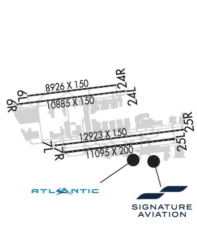
| Rwy | Rwy | |||||||
| 8926x150 | 8926' | 108.50 - 070° | 8926x150 | 8926' | 108.50 - 251° | |||
| 10885x150 | 10348' | 111.70 - 070° | 10885x150 | 10084' | 111.70 - 251° | |||
| 12923x150 | 12091' | 111.10 - 070° | 12923x150 | 11966' | 111.10 - 251° | |||
| 11095x200 | 11095' | 109.90 - 070° | 11095x200 | 11095' | 109.90 - 251° | |||
| Runway ID | Single Wheel | Double Wheel | Double Tandem Wheel | Dual Double Wheel |
| 06L/24R | 120,000 | 203,000 | 383,000 | 880,000 |
| 06R/24L | 120,000 | 250,000 | 550,000 | 1,120,000 |
| 07L/25R | 120,000 | 250,000 | 550,000 | 1,110,000 |
| 07R/25L | 120,000 | 250,000 | 550,000 | 1,120,000 |
| These numbers are Advisory and are not limits. The Airport Manager should have more accurate Weight Limits | ||||
 Airport Diagram might not be current. | |
| Facility Name: | LOS ANGELES INTL |
| City Name: | LOS ANGELES |
| County: | LOS ANGELES |
| State abbrev: | CA |
| State Name: | CALIFORNIA |
| Ownership: | PUBLICLY OWNED |
| Use: | OPEN TO THE PUBLIC |
| Owner's Name: | CITY OF LOS ANGELES |
| Address: | 1 WORLD WAY BOX 92216 |
| LOS ANGELES, CA 90009-2216 | |
| Owner's Phone: | 424-646-5292; ARPT OPNS 24 HRS. (424) 646-5292. |
| Manager's Name: | DOUGLAS WEBSTER |
| Address: | ONE WORLD WAY |
| LOS ANGELES, CA 90009 | |
| Phone: | 424-646-8829; LAX ARPT OPNS - CARY BUCHANAN 424-646-8257. |
| FAA Region: | WESTERN-PACIFIC |
| FAA Field Office: | LAX |
| Date | Sunrise | Sunset |
|---|---|---|
| 04/22/25 Tuesday | 6:15 | 19:30 |
| 04/23/25 Wednesday | 6:13 | 19:31 |
| 04/24/25 Thursday | 6:12 | 19:32 |
| 04/25/25 Friday | 6:11 | 19:33 |
| 04/26/25 Saturday | 6:10 | 19:33 |
| 04/27/25 Sunday | 6:09 | 19:34 |
| 04/28/25 Monday | 6:08 | 19:35 |
| 04/29/25 Tuesday | 6:07 | 19:36 |
| 04/30/25 Wednesday | 6:06 | 19:36 |
| 05/01/25 Thursday | 6:05 | 19:37 |
| 05/02/25 Friday | 6:04 | 19:38 |
| 05/03/25 Saturday | 6:03 | 19:39 |
| 05/04/25 Sunday | 6:02 | 19:40 |
| 05/05/25 Monday | 6:01 | 19:40 |
| Airport Attendance Schedule | CONTINUOUS |
| Airport Status | OPERATIONAL (This Status can change at any time - please check NOTAMS) |
| Airport Lighting Schedule | |
| Airport Storage Available | Tie Downs |
| Extra Services Available | Air Freight, Avionics, Cargo Handling, Charter |
| Wind Indicator | YES - (lighted) |
| Control Tower | YES |
| CTAF Frequency | |
| Unicom Frequency | 122.950 |
| Rotating Beacon Color | WG |
| Segmented Circle | NO |
| Landing Fee |
| Airport Inspected | FEDERAL - performed by FAA AIRPORTS FIELD PERSONNEL |
| Inspection Date | 07/25/2024 |
| Type of Fuel Available | JET A (freeze point -40C) |
| Airframe Repair Service | MAJOR |
| Power Plant Repair Service | MAJOR |
| Latitude | N3356.5 |
| Longitude | W11824.5 (ESTIMATED) |
| Arpt Elevation | 127ft (SURVEYED) |
| Magnetic Variation | 12E |
| 9 miles SW | of LOS ANGELES |
| Traffic Pattern Altitude | |
| Sectional Chart | LOS ANGELES |
| Operations (Reported) | Yearly | Avg. Daily |
|---|---|---|
| General Aviation Transient | 0 | 0 |
| General Aviation Local | 0 | 0 |
| Air Taxi | 0 | 0 |
| Commerical | 0 | 0 |
| Commuter | 0 | 0 |
| Military | 0 | 0 |
| Aircraft based on Field | |
|---|---|
| General Aviation Singles | 0 |
| General Aviation Multi | 0 |
| Jet Aircraft | 0 |
| General Aviation Helicopters | 0 |
| Military Aircraft | 0 |
| Gliders | 0 |
| Ultralights | 0 |
| FSS on field | NO |
| FSS tie-in | HAWTHORNE |
| FSS Phone | 1-800-WX-BRIEF |
| Who issues Notams | LAX |
| Notam D service at airport | YES |
| ARTCC Name | LOS ANGELES |
| Airport Certification | AIRPORT RECEIVING SCHEDULED AIR CARRIER SERVICE FROM CARRIERS CERTIFICATED BY THE CIVIL AERONAUTICS BOARD |
| Aircraft Rescue & Firefighting Index | AIRPORT HAS A CERTIFICATE UNDER CFR PART 139 |
| Airport of Entry | No |
| Custom Landing Rights | YES |
| Joint Civil/Military | No |
| Military Landing rights | No |
| NATIONAL PLAN OF INTEGRATED AIRPORT SYSTEMS (NPIAS) |
| GRANT AGREEMENTS UNDER FAAP/ADAP/AIP |
| SURPLUS PROPERTY AGREEMENT UNDER PUBLIC LAW 289 |
| ASSURANCES PURSUANT TO TITLE VI, CIVIL RIGHTS ACT OF 1964 |
| AGREEMENT UNDER DLAND OR DCLA HAS EXPIRED. |
| NOISE SENS ARPT ON WESTERLY TAKEOFFS NO TURNS BEFORE CROSSING SHORELINE OVER-OCEAN APCHS UTILIZED 0000-0630. |
| PRACTICE INSTRUMENT APPROACHES & TOUCH AND GO LANDINGS ARE PROHIBITED. |
| NMRS BIRDS ON AND IN VCNTY OF ARPT. |
| RWY 7R/25L PREFERRED EMERG RWY. |
| SIMUL ACFT OPNS PROHIBITED ON TWYS L AND H9 BTWN RWYS 07L/25R AND 07R/25L. |
| TURB MAY BE DEFLECTED UPWARD FM THE BLAST FENCE 180 FT E OF RWY 25R. |
| SIMUL ACFT OPNS PROHIBITED ON TWY H2 AND G BTN RWYS 07L/25R AND 07R/25L. |
| MILITARY RSTD: ALL MIL ACFT OFFL BUS ONLY, MIN 24 HR PPR, CTC 61 ABW/CP FLT OPS DSN 633-3779/4014, C310-653-3779/4014. |
| MILITARY AF: ALL MIL AIRCREWS MUST CTC 61 ABW/CP FLT OPS FOR PRKG LCTN/INSTRNS. NO GOVT TRNSPN, QTRS OR SECURITY AVBL. VIP NOTIFICATION PROCS APPLY. USER FEES ASSESSED USING AVCARD CREDIT. CTC SIGNATURE FLIGHT SUPPORT FBO 130.6 INBD. INBD RELAY ETA, VIP CODE, SVC REQ 30 MIN PRIOR TO ARR. |
| TWY D BTN TWY D7 AND D8 (N OF TRML ONE) CLSD TO ACFT WITH WINGSPAN GTR THAN 157 FT. |
| WEST REMOTE GATES: ACFT USE OF OPEN GATES AS TAXI PATH IS PROHIBITED (GATES 406, 407, 408, 409). |
| ACFT USE MINIMAL PWR WHEN TXG VCNTY TRMLS DUE BLAST HAZ. |
| FOR ACFT WITH WINGSPAN GTR THAN 214 FT CTC LAX AIRSIDE OPS (424)-646-5292 FOR ARPT RESTRICTIONS. |
| MAJOR CONSTRUCTION ON AIRPORT, DAILY. |
| AMERICAN EAGLE TRML SOUTHBOUND TAXING ACFT USE MNM PWR DUE TO BLAST HAZ. |
| SBND TURN NOT AVBL FROM WEST REMOTE GATE 408 AND WEST REMOTE GATE 409 |
| ANY ACFT THAT COMES TO A STOP OR HAS ITS MOMENTUM INTRPD WHILE TURNING AND TAXING INTO ITS PRKG PSN, MUST STOP AND BE TOWED. |
| ACFT WITH LEN GTR THAN 240 FT ARE PROHIBITED ON TXLS C7, C8 AND C9 BTN TXL C AND TWY B. |
| ACFT WITH WINGSPAN GTR THAN 198 FT OBND FM TXL D8 MAY NOT TURN WBND ONTO TXL D. |
| RWY STATUS LGTS IN OPN. |
| ACFT WITH WINGSPAN GTR THAN 155 FT WB ON TXL C ARE NOT AUTHD TO MAKE LEFT TURN ON TWY C10 UNDER PWR. |
| PILOTS SHOULD USE CTN FOR POSS LASER ACT IN THE LAX AREA. |
| LAX SVC TXL K AND TXL L LAWA RAMP TWR OPN CTC LAWA RAMP TWR 131.075. |
| LAX SVC TXL M LAWA RAMP TWR OPN CTC LAWA RAMP TWR 131.975. |
| RWY 06L/ 24RPCR VALUE: 610/R/A/W/T |
| RWY 06R/ 24LPCR VALUE: 980/R/A/W/T |
| RWY 07L/ 25RPCR VALUE: 870/R/A/W/T |
| RWY 07R/ 25LPCR VALUE: 1070/R/A/W/T |
Airport Communications & Frequencies:
| |||||||||||||||||||||||||||||||||||||||||||||||||||||||||||||||||||||||||||||||||||
| Runway: 06L | Runway: 24R | ||
| Mag heading: | 71° | Mag heading: | 251° |
| Rwy Slope: | .06% Up | Rwy Slope: | -.06% Down |
| Approach: | ILS/DME | Approach: | ILS/DME |
| Pattern: | Left Traffic | Pattern: | Right Traffic |
| Markings: | PRECISION INSTRUMENT | Markings: | PRECISION INSTRUMENT |
| Marking Condition: | GOOD | Marking Condition: | GOOD |
| Arresting Dev: | Arresting Dev: | ||
| Lat & Long: | N3356.9 W11825.9 | Lat. & Long.: | N3357.1 W11824.1 |
| Elev: | 113.1 ft. MSL | Elev: | 118.9 ft. MSL |
| TCH: | 77 ft. AGL | TCH: | 73 ft. AGL |
| Visual Glide Path: | 3.00 degrees | Visual Glide Path: | 3.00 degrees |
| Displaced Threshold: | No | Displaced Threshold: | No |
| Touchdown Zone: | YES | Touchdown Zone: | YES |
| Touchdown Elev.: | 118.8 feet | Touchdown Elev.: | 122.4 feet |
| Visual Glide Slope: | 4-Light PAPI on LEFT side of Runway | Visual Glide Slope: | 4-Light PAPI on LEFT side of Runway |
| RVR Equipment: | TOUCHDOWN-MIDFIELD-ROLLOUT | RVR Equipment: | TOUCHDOWN-MIDFIELD-ROLLOUT |
| RVV Equipment: | NO | RVV Equipment: | NO |
| Approach Lights: | MALSR - 1,400 foot medium intensity approach lighting system with runway alignment indicator lights | Approach Lights: | ALSF2 - standard 2,400 foot high intensity approach lighting system with sequenced flashers, Category II or III; ALSF2 OPERATES AS SSALR TILL WX GOES BELOW VFR. |
| REIL: | NO | REIL: | NO |
| Centerline Lights: | YES | Centerline Lights: | YES |
| Touchdown lights: | NO | Touchdown lights: | YES |
| Runway Category: | Precision Instrument Runway | Runway Category: | Precision Instrument Runway |
| Declared Distances: | TORA:8926' TODA:8926' ASDA:8566' LDA:8566' | Declared Distances: | TORA:8926' TODA:8926' ASDA:8926' LDA:8926' |
| Obstructions: | POLE | Obstructions: | SIGN |
| Marked: | NOT Marked/Lighted | Marked: | LIGHTED |
| Clearance slope: | 45:1 | Clearance slope: | 35:1 |
| Obstruction height: | 61 feet AGL | Obstruction height: | 42 feet AGL |
| Dist. from runway: | 3000 feet | Dist. from runway: | 1700 feet |
| Centerline offset: | 300 left of centerline | Centerline offset: | 350 feet right of centerline |
| Comments: | Comments: |
| Runway: 06R | Runway: 24L | ||
| Mag heading: | 71° | Mag heading: | 251° |
| Rwy Slope: | .03% Up | Rwy Slope: | -.03% Down |
| Approach: | ILS/DME | Approach: | ILS/DME |
| Pattern: | Left Traffic | Pattern: | Right Traffic |
| Markings: | PRECISION INSTRUMENT | Markings: | PRECISION INSTRUMENT |
| Marking Condition: | GOOD | Marking Condition: | GOOD |
| Arresting Dev: | Arresting Dev: | ||
| Lat & Long: | N3356.8 W11826.1 | Lat. & Long.: | N3357.0 W11823.9 |
| Elev: | 109.9 ft. MSL | Elev: | 112.9 ft. MSL |
| TCH: | 69 ft. AGL | TCH: | 79 ft. AGL |
| Visual Glide Path: | 3.00 degrees | Visual Glide Path: | 3.00 degrees |
| Displaced Threshold: | 537 feet | Displaced Threshold: | 801 feet |
| Touchdown Zone: | YES | Touchdown Zone: | YES |
| Touchdown Elev.: | 116.2 feet | Touchdown Elev.: | 122.5 feet |
| Visual Glide Slope: | 4-Light PAPI on LEFT side of Runway | Visual Glide Slope: | 4-Light PAPI on RIGHT side of Runway |
| RVR Equipment: | TOUCHDOWN-MIDFIELD-ROLLOUT | RVR Equipment: | TOUCHDOWN-MIDFIELD-ROLLOUT |
| RVV Equipment: | NO | RVV Equipment: | NO |
| Approach Lights: | MALSR - 1,400 foot medium intensity approach lighting system with runway alignment indicator lights | Approach Lights: | MALSR - 1,400 foot medium intensity approach lighting system with runway alignment indicator lights |
| REIL: | NO | REIL: | NO |
| Centerline Lights: | YES | Centerline Lights: | YES |
| Touchdown lights: | YES | Touchdown lights: | NO |
| Runway Category: | Precision Instrument Runway | Runway Category: | Precision Instrument Runway |
| Declared Distances: | TORA:10285' TODA:10285' ASDA:10285' LDA:9748' | Declared Distances: | TORA:10285' TODA:10285' ASDA:10285' LDA:9483' |
| Obstructions: | POLE | Obstructions: | |
| Marked: | NOT Marked/Lighted | Marked: | |
| Clearance slope: | 8:1; APCH RATIO 50:1 TO DSPLCD THR. | Clearance slope: | 50:1 |
| Obstruction height: | 9 feet AGL | Obstruction height: | |
| Dist. from runway: | 275 feet | Dist. from runway: | |
| Centerline offset: | 375 right of centerline | Centerline offset: | |
| Comments: | Comments: | ALS LIGHT BENCH AT 200'. |
| Runway: 07L | Runway: 25R | ||
| Mag heading: | 71° | Mag heading: | 251° |
| Rwy Slope: | -.16% Down | Rwy Slope: | .16% Up |
| Approach: | ILS/DME | Approach: | ILS/DME |
| Pattern: | Right Traffic | Pattern: | Left Traffic |
| Markings: | PRECISION INSTRUMENT | Markings: | PRECISION INSTRUMENT |
| Marking Condition: | GOOD | Marking Condition: | GOOD |
| Arresting Dev: | Arresting Dev: | ||
| Lat & Long: | N3356.1 W11825.3 | Lat. & Long.: | N3356.4 W11822.8 |
| Elev: | 114.8 ft. MSL | Elev: | 94.3 ft. MSL |
| TCH: | 83 ft. AGL | TCH: | 75 ft. AGL |
| Visual Glide Path: | 3.00 degrees | Visual Glide Path: | 3.00 degrees |
| Displaced Threshold: | 832 feet | Displaced Threshold: | 957 feet |
| Touchdown Zone: | YES | Touchdown Zone: | YES |
| Touchdown Elev.: | 127.8 feet | Touchdown Elev.: | 103.8 feet |
| Visual Glide Slope: | 4-Light PAPI on LEFT side of Runway | Visual Glide Slope: | 4-Light PAPI on LEFT side of Runway |
| RVR Equipment: | TOUCHDOWN-MIDFIELD-ROLLOUT | RVR Equipment: | TOUCHDOWN-MIDFIELD-ROLLOUT |
| RVV Equipment: | NO | RVV Equipment: | NO |
| Approach Lights: | MALSR - 1,400 foot medium intensity approach lighting system with runway alignment indicator lights | Approach Lights: | MALSR - 1,400 foot medium intensity approach lighting system with runway alignment indicator lights |
| REIL: | NO | REIL: | NO |
| Centerline Lights: | YES | Centerline Lights: | YES |
| Touchdown lights: | YES | Touchdown lights: | NO |
| Runway Category: | Precision Instrument Runway | Runway Category: | Precision Instrument Runway |
| Declared Distances: | TORA:12091' TODA:12091' ASDA:12091' LDA:11259' | Declared Distances: | TORA:12091' TODA:12091' ASDA:12091' LDA:11134' |
| Obstructions: | Obstructions: | RR | |
| Marked: | Marked: | LIGHTED | |
| Clearance slope: | 50:1 | Clearance slope: | 5:1; APCH RATIO 33:1 TO DSPLCD THR. CTLG OBS IS A +29' SIGN LOCATED 1450' FM DSPLCD THR AND 500' R OF CNTRLN. |
| Obstruction height: | Obstruction height: | 25 feet AGL | |
| Dist. from runway: | Dist. from runway: | 325 feet | |
| Centerline offset: | 400 right of centerline | Centerline offset: | |
| Comments: | Comments: | 14 FT BLAST FENCE AT 180 FT. |
| Runway: 07R | Runway: 25L | ||
| Mag heading: | 71° | Mag heading: | 251° |
| Rwy Slope: | -.22% Down | Rwy Slope: | .22% Up |
| Approach: | ILS/DME | Approach: | ILS/DME |
| Pattern: | Right Traffic | Pattern: | Left Traffic |
| Markings: | PRECISION INSTRUMENT | Markings: | PRECISION INSTRUMENT |
| Marking Condition: | GOOD | Marking Condition: | GOOD |
| Arresting Dev: | Arresting Dev: | ||
| Lat & Long: | N3356.0 W11825.1 | Lat. & Long.: | N3356.2 W11823.0 |
| Elev: | 121.7 ft. MSL | Elev: | 97.8 ft. MSL |
| TCH: | 57 ft. AGL | TCH: | 70 ft. AGL |
| Visual Glide Path: | 3.00 degrees | Visual Glide Path: | 3.00 degrees |
| Displaced Threshold: | No | Displaced Threshold: | No |
| Touchdown Zone: | YES | Touchdown Zone: | YES |
| Touchdown Elev.: | 127.6 feet | Touchdown Elev.: | 103.7 feet |
| Visual Glide Slope: | 4-Light PAPI on LEFT side of Runway | Visual Glide Slope: | 4-Light PAPI on RIGHT side of Runway |
| RVR Equipment: | TOUCHDOWN-MIDFIELD-ROLLOUT | RVR Equipment: | TOUCHDOWN-MIDFIELD-ROLLOUT |
| RVV Equipment: | NO | RVV Equipment: | NO |
| Approach Lights: | MALSR - 1,400 foot medium intensity approach lighting system with runway alignment indicator lights | Approach Lights: | ALSF2 - standard 2,400 foot high intensity approach lighting system with sequenced flashers, Category II or III; ALSF2 OPERATES AS SSALR TILL WX GOES BELOW VFR. |
| REIL: | NO | REIL: | NO |
| Centerline Lights: | YES | Centerline Lights: | YES |
| Touchdown lights: | NO | Touchdown lights: | YES |
| Runway Category: | Precision Instrument Runway | Runway Category: | Precision Instrument Runway |
| Declared Distances: | TORA:11095' TODA:11095' ASDA:11095' LDA:11095' | Declared Distances: | TORA:11095' TODA:11095' ASDA:11095' LDA:11095' |
| Obstructions: | POLE | Obstructions: | RR |
| Marked: | NOT Marked/Lighted | Marked: | NOT Marked/Lighted |
| Clearance slope: | 32:1 | Clearance slope: | 45:1 |
| Obstruction height: | 67 feet AGL | Obstruction height: | 21 feet AGL |
| Dist. from runway: | 2400 feet | Dist. from runway: | 1150 feet |
| Centerline offset: | 825 right of centerline | Centerline offset: | 600 feet left of centerline |
| Comments: | Comments: |
Thanks for using FltPlan.com
all rights reserved © 1999-2025 by Flight Plan LLC


