
| LUBBOCK PRESTON SMITH INTL LUBBOCK TX |
| |
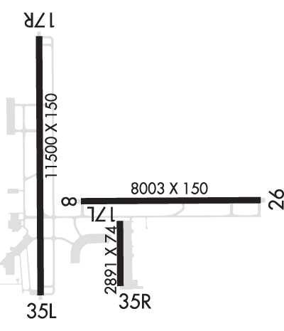
| Lat: N 3339.8 Long: W 10149.2 Elev: 3282 Var: -06 Longest Runway: 11500 | ||
| Clr Del: 125.8 Dept. ATIS: 125.3 Arr. ATIS: 125.3 Ground: 121.9 Tower: 120.5 | ||
| ||||||||||||||||||||||||||||||||||||||||||||
| ||||||||||||||||||||||||||||||||||||||||||||
| ||||||||||||||||||||||||||||||||||||||||||||
| ||||||||||||||||||||||||||||||||||||||||||||
| Rwy | Rwy | |||||||
| 8003x150 | 8003' | 8003x150 | 8003' | 111.90 - 263° | ||||
| 2891x74 | 2891' | 2891x74 | 2891' | |||||
| 11500x150 | 11500' | 111.70 - 173° | 11500x150 | 11500' | ||||
| Runway ID | Single Wheel | Double Wheel | Double Tandem Wheel | Dual Double Wheel |
| 08/26 | 100,000 | 170,000 | 350,000 | N/A |
| 17L/35R | 12,500 | N/A | N/A | N/A |
| 17R/35L | 100,000 | 170,000 | 350,000 | N/A |
| These numbers are Advisory and are not limits. The Airport Manager should have more accurate Weight Limits | ||||
 Airport Diagram might not be current. | |
| Facility Name: | LUBBOCK PRESTON SMITH INTL |
| City Name: | LUBBOCK |
| County: | LUBBOCK |
| State abbrev: | TX |
| State Name: | TEXAS |
| Ownership: | PUBLICLY OWNED |
| Use: | OPEN TO THE PUBLIC |
| Owner's Name: | CITY OF LUBBOCK |
| Address: | PO BOX 2000 |
| LUBBOCK, TX 79457 | |
| Owner's Phone: | 806-775-3000 |
| Manager's Name: | KELLY CAMPBELL |
| Address: | RT 3 BOX 389 |
| LUBBOCK, TX 79401 | |
| Phone: | 806-775-3126 |
| FAA Region: | SOUTHWEST |
| FAA Field Office: | TEX |
| Date | Sunrise | Sunset |
|---|---|---|
| 09/24/21 Friday | 7:37 | 19:41 |
| 09/25/21 Saturday | 7:37 | 19:40 |
| 09/26/21 Sunday | 7:38 | 19:39 |
| 09/27/21 Monday | 7:39 | 19:37 |
| 09/28/21 Tuesday | 7:39 | 19:36 |
| 09/29/21 Wednesday | 7:40 | 19:35 |
| 09/30/21 Thursday | 7:41 | 19:33 |
| 10/01/21 Friday | 7:41 | 19:32 |
| 10/02/21 Saturday | 7:42 | 19:31 |
| 10/03/21 Sunday | 7:43 | 19:29 |
| 10/04/21 Monday | 7:44 | 19:28 |
| 10/05/21 Tuesday | 7:44 | 19:27 |
| 10/06/21 Wednesday | 7:45 | 19:25 |
| 10/07/21 Thursday | 7:46 | 19:24 |
| Airport Attendance Schedule | CONTINUOUS |
| Airport Status | OPERATIONAL (This Status can change at any time - please check NOTAMS) |
| Airport Lighting Schedule | SS-SR |
| Airport Storage Available | Tie Downs, Hanger |
| Extra Services Available | Air Freight, Air Ambulance, Avionics, Charter, Flight Instruction, Aircraft Sales |
| Wind Indicator | YES - (lighted) |
| Control Tower | YES |
| CTAF Frequency | |
| Unicom Frequency | 122.950 |
| Rotating Beacon Color | CLEAR-GREEN (Light Land Airport) |
| Segmented Circle | NO |
| Landing Fee | NO |
| Airport Inspected | FEDERAL - performed by FAA AIRPORTS FIELD PERSONNEL |
| Inspection Date | 07/20/2017 |
| Type of Fuel Available | Grade 100LL, JET A (freeze point -40C), JET A-1 (icing inhibitor, freeze point -50C) |
| Airframe Repair Service | MAJOR |
| Power Plant Repair Service | MAJOR |
| Latitude | N3339.8 |
| Longitude | W10149.2 (ESTIMATED) |
| Arpt Elevation | 3282ft (SURVEYED) |
| Magnetic Variation | 06E |
| 4 miles N | of LUBBOCK |
| Traffic Pattern Altitude | |
| Sectional Chart | DALLAS-FT WORTH |
| Operations (Reported) | Yearly | Avg. Daily |
|---|---|---|
| General Aviation Transient | 24627 | 67 |
| General Aviation Local | 12953 | 35 |
| Air Taxi | 17933 | 49 |
| Commerical | 12901 | 35 |
| Commuter | 0 | 0 |
| Military | 7052 | 19 |
| Aircraft based on Field | |
|---|---|
| General Aviation Singles | 100 |
| General Aviation Multi | 35 |
| Jet Aircraft | 19 |
| General Aviation Helicopters | 2 |
| Military Aircraft | 0 |
| Gliders | 0 |
| Ultralights | 0 |
| FSS on field | NO |
| FSS tie-in | FORT WORTH |
| FSS Phone | 1-800-WX-BRIEF |
| Who issues Notams | LBB |
| Notam D service at airport | YES |
| ARTCC Name | FORT WORTH |
| Airport Certification | AIRPORT RECEIVING SCHEDULED AIR CARRIER SERVICE FROM CARRIERS CERTIFICATED BY THE CIVIL AERONAUTICS BOARD |
| Aircraft Rescue & Firefighting Index | AIRPORT HAS A CERTIFICATE UNDER CFR PART 139 |
| Airport of Entry | No |
| Custom Landing Rights | YES |
| Joint Civil/Military | No |
| Military Landing rights | YES |
| NATIONAL PLAN OF INTEGRATED AIRPORT SYSTEMS (NPIAS) |
| GRANT AGREEMENTS UNDER FAAP/ADAP/AIP |
| SURPLUS PROPERTY AGREEMENT UNDER PUBLIC LAW 289 |
| ASSURANCES PURSUANT TO TITLE VI, CIVIL RIGHTS ACT OF 1964 |
| RY 17L/35R RESTRICTED TO GENERAL AVIATION ACFT 12,500 LBS OR LESS. |
| TWY L BTN TWY F AND TWY J CLSD TO MORE THAN 120001 LB. |
| TWYS B; D; & E RSTD TO ACFT WEIGHING LESS THAN 50,000 LBS. |
| PASSENGER TERMINAL RAMP ACCESS RSTD TO AIR CARRIERS & OTHERS WITH PRIOR PERMISSION CALL 806-775-2044. |
| RY 17L/35R; TWYS B; D; & E NOT AVBL FOR ACR ACFT WITH OVER 9 PSGR SEATS. |
| NUMEROUS BIRDS ON & INVOF ARPT. |
| EAST RAMP DELINEATED TAXILANE & APRON AREA RESTRICTED TO 120,000 LBS DUAL TANDEM ACFT, 89,000 LBS DUAL SINGLE WHEEL ACFT & 60,000 LBS SINGLE WHEEL ACFT. ALL OTHER EAST RAMP PAVEMENTS RESTRICTED TO ACFT LESS THAN 12,500 LBS SINGLE WHEEL ACFT. |
| PAEW ADJ RYS 08/26 & 17R/35L. |
Airport Communications & Frequencies:
| ||||||||||||||||||||||||||||||||||||||||||||||||||||
| Runway: 08 | Runway: 26 | ||
| Mag heading: | 83° | Mag heading: | 263° |
| Rwy Slope: | -.07% Down | Rwy Slope: | .07% Up |
| Approach: | Approach: | ILS | |
| Pattern: | Right Traffic | Pattern: | Left Traffic |
| Markings: | PRECISION INSTRUMENT | Markings: | PRECISION INSTRUMENT |
| Marking Condition: | GOOD | Marking Condition: | GOOD |
| Arresting Dev: | Arresting Dev: | ||
| Lat & Long: | N3339.7 W10149.4 | Lat. & Long.: | N3339.7 W10147.8 |
| Elev: | 3258.3 ft. MSL | Elev: | 3252.6 ft. MSL |
| TCH: | 50 ft. AGL | TCH: | 50 ft. AGL |
| Visual Glide Path: | 3.00 degrees | Visual Glide Path: | 3.00 degrees |
| Displaced Threshold: | No | Displaced Threshold: | No |
| Touchdown Zone: | YES | Touchdown Zone: | YES |
| Touchdown Elev.: | 3258.2 feet | Touchdown Elev.: | 3254.7 feet |
| Visual Glide Slope: | 4-Light PAPI on LEFT side of Runway | Visual Glide Slope: | 4-Light PAPI on LEFT side of Runway |
| RVR Equipment: | ROLLOUT | RVR Equipment: | TOUCHDOWN |
| RVV Equipment: | NO | RVV Equipment: | NO |
| Approach Lights: | Approach Lights: | MALSR - 1,400 foot medium intensity approach lighting system with runway alignment indicator lights | |
| REIL: | YES | REIL: | NO |
| Centerline Lights: | NO | Centerline Lights: | NO |
| Touchdown lights: | NO | Touchdown lights: | NO |
| Runway Category: | Runway with a Non-precision Approach having visibility minimums greater than 3/4 mile | Runway Category: | Precision Instrument Runway |
| Declared Distances: | TORA:8003' TODA:8003' ASDA:8003' LDA:8003' | Declared Distances: | TORA:8003' TODA:8003' ASDA:8003' LDA:8003' |
| Runway: 17L | Runway: 35R | ||
| Mag heading: | 174° | Mag heading: | 354° |
| Rwy Slope: | .27% Up | Rwy Slope: | -.27% Down |
| Approach: | Approach: | ||
| Pattern: | Left Traffic | Pattern: | Right Traffic |
| Markings: | BASIC | Markings: | BASIC |
| Marking Condition: | GOOD | Marking Condition: | GOOD |
| Arresting Dev: | Arresting Dev: | ||
| Lat & Long: | N3339.6 W10149.0 | Lat. & Long.: | N3339.1 W10149.0 |
| Elev: | 3254.6 ft. MSL | Elev: | 3262.4 ft. MSL |
| TCH: | TCH: | ||
| Visual Glide Path: | Visual Glide Path: | ||
| Displaced Threshold: | No | Displaced Threshold: | No |
| Touchdown Zone: | YES | Touchdown Zone: | YES |
| Touchdown Elev.: | 3262.4 feet | Touchdown Elev.: | 3262.4 feet |
| Visual Glide Slope: | Visual Glide Slope: | ||
| RVR Equipment: | RVR Equipment: | ||
| RVV Equipment: | NO | RVV Equipment: | NO |
| Approach Lights: | Approach Lights: | ||
| REIL: | NO | REIL: | NO |
| Centerline Lights: | NO | Centerline Lights: | NO |
| Touchdown lights: | NO | Touchdown lights: | NO |
| Runway Category: | Runway with a Visual Approach | Runway Category: | Runway with a Visual Approach |
| Declared Distances: | TORA:2891' TODA:2891' ASDA:2891' LDA:2891' | Declared Distances: | TORA:2891' TODA:2891' ASDA:2891' LDA:2891' |
| Obstructions: | Obstructions: | ROAD | |
| Marked: | Marked: | NOT Marked/Lighted | |
| Clearance slope: | 50:1 | Clearance slope: | 20:1 |
| Obstruction height: | Obstruction height: | 18 feet AGL | |
| Dist. from runway: | Dist. from runway: | 573 feet | |
| Centerline offset: | Centerline offset: | 162 feet right of centerline | |
| Comments: | Comments: |
| Runway: 17R | Runway: 35L | ||
| Mag heading: | 174° | Mag heading: | 354° |
| Rwy Slope: | -.35% Down | Rwy Slope: | .35% Up |
| Approach: | ILS/DME | Approach: | |
| Pattern: | Right Traffic | Pattern: | Left Traffic |
| Markings: | PRECISION INSTRUMENT | Markings: | PRECISION INSTRUMENT |
| Marking Condition: | GOOD | Marking Condition: | GOOD |
| Arresting Dev: | Arresting Dev: | ||
| Lat & Long: | N3340.9 W10149.7 | Lat. & Long.: | N3339.0 W10149.7 |
| Elev: | 3282.4 ft. MSL | Elev: | 3242.5 ft. MSL |
| TCH: | 69 ft. AGL | TCH: | 54 ft. AGL |
| Visual Glide Path: | 3.00 degrees | Visual Glide Path: | 3.00 degrees |
| Displaced Threshold: | No | Displaced Threshold: | No |
| Touchdown Zone: | YES | Touchdown Zone: | YES |
| Touchdown Elev.: | 3282.4 feet | Touchdown Elev.: | 3254.1 feet |
| Visual Glide Slope: | 4-Light PAPI on RIGHT side of Runway | Visual Glide Slope: | 4-BOX VASI ON LEFT SIDE OF RUNWAY |
| RVR Equipment: | TOUCHDOWN | RVR Equipment: | ROLLOUT |
| RVV Equipment: | NO | RVV Equipment: | NO |
| Approach Lights: | MALSR - 1,400 foot medium intensity approach lighting system with runway alignment indicator lights | Approach Lights: | |
| REIL: | NO | REIL: | NO |
| Centerline Lights: | NO | Centerline Lights: | NO |
| Touchdown lights: | NO | Touchdown lights: | NO |
| Runway Category: | Precision Instrument Runway | Runway Category: | D |
| Declared Distances: | TORA:11500' TODA:11500' ASDA:11500' LDA:11500' | Declared Distances: | TORA:11500' TODA:11500' ASDA:11500' LDA:11500' |
Thanks for using FltPlan.com
all rights reserved © 1999-2021 by Flight Plan LLC
