
| HARRISBURG INTL HARRISBURG PA |
| |
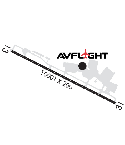
| Lat: N 4011.6 Long: W 07645.8 Elev: 310 Var: +11 Longest Runway: 10001 | ||
| Dept. ATIS: 118.8 Arr. ATIS: 118.8 Ground: 121.7 Tower: 124.8 | ||

| ||||||||||||||||||||||||||||||||||||||||||||
| ||||||||||||||||||||||||||||||||||||||||||||
| ||||||||||||||||||||||||||||||||||||||||||||
| Rwy | Rwy | |||||||
| 10001x200 | 9008' | 110.90 - 127° | 10001x200 | 9008' | 110.90 - 307° | |||
| Runway ID | Single Wheel | Double Wheel | Double Tandem Wheel | Dual Double Wheel |
| 13/31 | 155,000 | 330,000 | 550,000 | N/A |
| These numbers are Advisory and are not limits. The Airport Manager should have more accurate Weight Limits | ||||
 Airport Diagram might not be current. | |
| Facility Name: | HARRISBURG INTL |
| City Name: | HARRISBURG |
| County: | DAUPHIN |
| State abbrev: | PA |
| State Name: | PENNSYLVANIA |
| Ownership: | PUBLICLY OWNED |
| Use: | OPEN TO THE PUBLIC |
| Owner's Name: | SUSQUEHANNA AREA REGIONAL ARPT AUTH |
| Address: | ONE TERMINAL DRIVE |
| MIDDLETOWN, PA 17057 | |
| Owner's Phone: | 717-948-3900 |
| Manager's Name: | TIM EDWARDS |
| Address: | ONE TERMINAL DRIVE |
| MIDDLETOWN, PA 17057 | |
| Phone: | 717-948-3900 |
| FAA Region: | EASTERN |
| FAA Field Office: | HAR |

| Date | Sunrise | Sunset |
|---|---|---|
| 04/26/25 Saturday | 6:14 | 19:57 |
| 04/27/25 Sunday | 6:12 | 19:58 |
| 04/28/25 Monday | 6:11 | 19:59 |
| 04/29/25 Tuesday | 6:10 | 20:00 |
| 04/30/25 Wednesday | 6:08 | 20:01 |
| 05/01/25 Thursday | 6:07 | 20:02 |
| 05/02/25 Friday | 6:06 | 20:03 |
| 05/03/25 Saturday | 6:05 | 20:04 |
| 05/04/25 Sunday | 6:03 | 20:05 |
| 05/05/25 Monday | 6:02 | 20:06 |
| 05/06/25 Tuesday | 6:01 | 20:07 |
| 05/07/25 Wednesday | 6:00 | 20:08 |
| 05/08/25 Thursday | 5:59 | 20:09 |
| 05/09/25 Friday | 5:58 | 20:10 |
| Airport Attendance Schedule | CONTINUOUS |
| Airport Status | OPERATIONAL (This Status can change at any time - please check NOTAMS) |
| Airport Lighting Schedule | |
| Airport Storage Available | Tie Downs, Hanger |
| Extra Services Available | Avionics, Charter, Flight Instruction, Aircraft Rental |
| Wind Indicator | YES - (lighted) |
| Control Tower | YES |
| CTAF Frequency | |
| Unicom Frequency | |
| Rotating Beacon Color | WG |
| Segmented Circle | NO |
| Landing Fee | YES |
| Airport Inspected | FEDERAL - performed by FAA AIRPORTS FIELD PERSONNEL |
| Inspection Date | 03/17/2025 |
| Type of Fuel Available | Grade 100LL, JET A (freeze point -40C) |
| Airframe Repair Service | MAJOR |
| Power Plant Repair Service | MAJOR |
| Latitude | N4011.6 |
| Longitude | W07645.8 (ESTIMATED) |
| Arpt Elevation | 310ft (SURVEYED) |
| Magnetic Variation | 11W |
| 8 miles SE | of HARRISBURG |
| Traffic Pattern Altitude | TPA 1300 FT MSL (990 FT AGL) PROPS; 1800 FT MSL (1490 FT AGL) JETS. |
| Sectional Chart | NEW YORK |
| Operations (Reported) | Yearly | Avg. Daily |
|---|---|---|
| General Aviation Transient | 0 | 0 |
| General Aviation Local | 0 | 0 |
| Air Taxi | 0 | 0 |
| Commerical | 0 | 0 |
| Commuter | 0 | 0 |
| Military | 0 | 0 |
| Aircraft based on Field | |
|---|---|
| General Aviation Singles | 0 |
| General Aviation Multi | 0 |
| Jet Aircraft | 0 |
| General Aviation Helicopters | 0 |
| Military Aircraft | 0 |
| Gliders | 0 |
| Ultralights | 0 |
| FSS on field | NO |
| FSS tie-in | WILLIAMSPORT |
| FSS Phone | 1-800-WX-BRIEF |
| Who issues Notams | MDT |
| Notam D service at airport | YES |
| ARTCC Name | NEW YORK |
| Airport Certification | AIRPORT RECEIVING SCHEDULED AIR CARRIER SERVICE FROM CARRIERS CERTIFICATED BY THE CIVIL AERONAUTICS BOARD |
| Aircraft Rescue & Firefighting Index | AIRPORT HAS A CERTIFICATE UNDER CFR PART 139 |
| Airport of Entry | No |
| Custom Landing Rights | YES |
| Joint Civil/Military | No |
| Military Landing rights | YES |
| NATIONAL PLAN OF INTEGRATED AIRPORT SYSTEMS (NPIAS) |
| GRANT AGREEMENTS UNDER FAAP/ADAP/AIP |
| SURPLUS PROPERTY AGREEMENT UNDER PUBLIC LAW 289 |
| ADVANCE PLANNING AGREEMENT UNDER FAAP |
| ASSURANCES PURSUANT TO TITLE VI, CIVIL RIGHTS ACT OF 1964 |
| ACFT DESTINED FOR AVFLIGHT HARRISBURG SO INDICATE IN |
| BIRD WATCH COND PHASE 1 (DEC-FEB & MAY-JUL) INDICATED LGT BIRD ACT. PHASE 2 (AUG-NOV & MAR-APR) INDICATES HVY BIRD ACT NML ASSOCIATED WITH MIGRATORY SEASON. |
| CARGO APRON PARKING SPOT 9 CLOSED TO ACFT WITH A WINGSPAN OF MORE THAN 52 FT. |
| COLD TEMPERATURE AIRPORT. ALTITUDE CORRECTION REQUIRED AT OR BELOW -17C. |
| USE CTN: DUE TO PROXIMITY & RWY ALMNT, AIRCREWS HAVE MISTAKEN CXY RWY 12/30 FOR MDT RWY 13/31 WHICH IS 4 NM E. |
| CARGO RAMP CLSD TO TSNT ACFT WO PRIOR PERMISSION; CALL AMGR 717-948-3919. |
| BIRD FLOCKS ON & INVOF ARPT. |
| NO TOUCH & GO LDGS 2300-0600 LCL. |
| REMARKS-ANG: ACFT NOT SUPPORTING ANG AND ALL FIGHTER ACFT MUST CTC FBO C 717-944-4666 FOR PRK AND FUEL. NSTD MRK ON C130J PRK APRON SPOT 5; WHITE PAINTED LINES DENOTING LAIRCM LASER TESTING AREA. |
| RWY 13/3 1 PCR VALUE: 800/F/C/X/T |
Airport Communications & Frequencies:
| ||||||||||||||||||||||||||||||||||||||||||||||||||||||
| Runway: 13 | Runway: 31 | ||
| Mag heading: | 128° | Mag heading: | 308° |
| Rwy Slope: | .00% Down | Rwy Slope: | .00% Up |
| Approach: | ILS | Approach: | ILS |
| Pattern: | Left Traffic | Pattern: | Right Traffic |
| Markings: | PRECISION INSTRUMENT | Markings: | PRECISION INSTRUMENT |
| Marking Condition: | GOOD | Marking Condition: | GOOD |
| Arresting Dev: | Arresting Dev: | ||
| Lat & Long: | N4012.0 W07646.7 | Lat. & Long.: | N4011.2 W07644.8 |
| Elev: | 310.0 ft. MSL | Elev: | 309.7 ft. MSL |
| TCH: | 75 ft. AGL | TCH: | 51 ft. AGL |
| Visual Glide Path: | 3.00 degrees | Visual Glide Path: | 3.00 degrees |
| Displaced Threshold: | 993 feet | Displaced Threshold: | 993 feet |
| Touchdown Zone: | YES | Touchdown Zone: | YES |
| Touchdown Elev.: | 308.0 feet | Touchdown Elev.: | 307.8 feet |
| Visual Glide Slope: | 4-Light PAPI on LEFT side of Runway | Visual Glide Slope: | 4-Light PAPI on LEFT side of Runway |
| RVR Equipment: | TOUCHDOWN-MIDFIELD-ROLLOUT | RVR Equipment: | TOUCHDOWN-MIDFIELD-ROLLOUT |
| RVV Equipment: | NO | RVV Equipment: | NO |
| Approach Lights: | ALSF2 - standard 2,400 foot high intensity approach lighting system with sequenced flashers, Category II or III | Approach Lights: | |
| REIL: | NO | REIL: | YES |
| Centerline Lights: | YES | Centerline Lights: | YES |
| Touchdown lights: | YES | Touchdown lights: | NO |
| Runway Category: | Precision Instrument Runway | Runway Category: | Precision Instrument Runway |
| Declared Distances: | TORA:10001' TODA:10001' ASDA:9063' LDA:8070' | Declared Distances: | TORA:10001' TODA:10001' ASDA:9122' LDA:8129' |
| Obstructions: | POLE | Obstructions: | TREES |
| Marked: | NOT Marked/Lighted | Marked: | NOT Marked/Lighted |
| Clearance slope: | 26:1; APCH RATIO 47:1 TO DTHR. | Clearance slope: | 27:1; APCH SLOPE 41:1 TO DTHR. |
| Obstruction height: | 60 feet AGL | Obstruction height: | 60 feet AGL |
| Dist. from runway: | 1780 feet | Dist. from runway: | 1802 feet |
| Centerline offset: | 719 left of centerline | Centerline offset: | 350 feet right of centerline |
| Comments: | Comments: |
Thanks for using FltPlan.com
all rights reserved © 1999-2025 by Flight Plan LLC